I am very sorry for not posting about the storm threat today, but I have been very busy. The main line of storms is beginning to shift out of Northwest Ohio. Behind this line of thunderstorms, temperatures will rise quickly into the mid and upper 50's, with a few places mainly south of Fort Wayne, reaching into the lower 60's. This could generate enough instability ahead of the cold front, that a low-topped squall line could develop and race through areas SOUTH of Fort Wayne. I do not think that any town north or northwest of Fort Wayne will see severe weather, so do not expect it. Even areas northeast of Fort Wayne will probably have a hard time seeing any kind of strong thunderstorm. There will be strong lifting and forcing which would replace the need for instability, which is why the Storm Prediction Center has said that the only way that we could get severe weather is if this low-topped squall line forms, which will bring strong, damaging winds and possibly some hail, maybe even a weak tornado. Other than that, the cold front will pass through near early evening, with lapse rates becoming very high, allowing the transport of momentum of high wind aloft to the surface, combined with the strong surface pressure gradient, which will cause winds higher than 40 knots, which is near 50 mph. This may mean that our wind advisory could be upgraded to a High Wind Warning, especially if gusts become over 55 mph. Temperatures will rapidly drop into the lower 30's tonight, with snow showers possibly pivoting into the area with the comma head. On Sunday, a shortwave will drop through bringing a greater chance for snow showers and much colder temperatures than what we have been seeing. By next week, another warm up will be on the way, with possibly another heavy rain event/ or severe weather event by Thursday. I will keep an eye on this over the next couple of days.
Friday, March 2, 2012

Wednesday, February 29, 2012
Incredibly Warm Day.
After a very cool and foggy start to the day (and after quite a bit of rain over a half an inch), skies have competely cleared and temperatures have soared into the upper 60's in most if not all areas south of Route 6. Most areas north of Route 6 are still seeing temperatures in the fifties and cities such as Toledo haven't even hit 50 yet today! Currently in Antwerp, the temperature is steady right near 69 degrees, with Fort Wayne at a very warm 68. I can tell you this, these temperatures were a lot higher than what I was expecting earlier today. I actually thought that temperatures may not even hit 60 when I woke up this morning, the warm advection behind the warm front was so incredible and the mixing was so incredible, that temperatures were many degrees warmer than MOS guidance and computer models. It still does appear that thunderstorms will not form this afternoon, as the dry line is moving through right now, without initiating an convective development. Even with the weak to moderate surface based instability, thunderstorms still have not had a chance to form. After the cold front moves through, which will probably happen around 5 or 6 p.m., winds will continue to be strong for a little while longer before subsiding, as the upper level trough pivots through the area. Most if not all wrap around precipitation will hit north of the area, with some showers around the Michigan. As for the next couple of days, by Friday, another strong system will be located in the area, with heavy rain and severe weather all possible once again, including very warm temperatures. I will have more updates tomorrow on this storm.
Tuesday, February 28, 2012
Forecast Update
It seems as if tomorrow's situation keeps changing every hour, so I will give you the latest consensus among the data. It looks like the rain will probably start a bit later than what I said yesterday. Yesterday, I mentioned that precipitation would probably start after 11 p.m., well now, it looks like rain will start around midnight. In my opinion, I still think that precipitation will begin around the late evening hours, probably around 10 or 11 tonight. It just all depends on how quickly the storm system moving into the plains occludes, because storm systems tend to accelerate until they occlude, which by that time, they tend to slow down considerably. This will lead to timing issues with the onset of strong isentropic upglide, upper level forcing, the works... which will all eventually lead to the point at which the atmosphere above is saturated. As was the trend in models, the storm looks to strengthen and accelerate for the next few hours, then occluding over the Northern Plains somewhere over southern Minnesota. The storm looks to become fairly strong before becoming vertically stacked (this means that the storm system does not have a tilt to it when moving up from the earth's surface. In a strengthening storm system, the surface low is located farthest east, while the 500 and 300 millibar lows and troughs, tend to be located north and west of the surface low. When a low pressure system becomes vertically stacked, all of the upper level storm systems are located directly above the low, causing it to strengthen for a little while longer, but then weaken as it is source of development has been cut off.), which at the time that it is expected to become vertically stacked, the warm sector will be right over the area. Tonight, no matter what time the rain arrives, it will become steadier and heavier with time, with embedded heavy thunderstorm development after 3 a.m. By 7 a.m., scattered heavy thunderstorms will still be located in the area, leading to localized heavy rainfall amounts in some parts of the area. After 9 a.m., most if not all thunderstorm development will cease, with rapidly clearing skies and strong southerly winds bringing in warm, moist air to the region. Temperatures will soar into the lower and middle 60's across the area, with upper 50's at the Michigan border. With increasing lapse rates, strong mixing will occur, bringing much higher winds aloft to the surface, increasing wind speeds as high as 40-50 mph. Strong mixing could also cause the development of showers and thunderstorms in the warm sector ahead of the mesoscale dry line that is expected to pass through the area. Right now, the highest chance for scattered thunderstorms after 2 p.m. is expected east of I-69, as the axis of highest instability and highest moisture, will move through the areas at the same time that low level convergence will be strongest. Some models such as the GFS, are indicating that mixing will be so strong that dry air aloft will mix down to the surface, inhibiting significant convective development. On the otherhand, the NAM has dew points well above what the GFS is forecasting, with dew points near 60, with temperatures near 65. This would potential lead to thunderstorm development, but the NAM also has a very narrow opportunity for thunderstorm development, dry air mixing to the surface after 4 p.m., so thunderstorms may not ever form tomorrow afternoon, not in our area to the say the least. My current thinking is that thunderstorms will form if the NAM is correct with the higher dew points in the area, especially if the left exit region of the jet streak ends up right over our area. These thunderstorms could produce gusty winds and some small hail as they pass quickly through the area. After they pass, the cold front will quickly pass through the area, with temperatures quickly dropping, but with strong winds continuing throughout the late afternoon. Some showers and maybe a snow shower may pivot through the area by nightfall, with mostly cloudy skies and falling temperatures. After this storm passes through, our attention will focus on the next potentially major storm system, which will further impact the area by Friday and Friday night. Stay tuned for further updates.
Monday, February 27, 2012
A Few Changes
It was very nice day today, with highs approaching the mid 40's under sunny skies. Winds did get quite strong today, with gusts as high 30 mph. One of the few things I would like to change to my forecast is tonight's low temperatures. It seems as if the winds will dying down earlier than what was expected, plus, the cold front currently moving through the area was producing more substantial cold air advection than what I was expecting last night. So expect lows tonight to drop down to about 23-25 degrees, under clear skies, and relatively light winds. By tomorrow, clouds will begin to move in from the west, with skies mostly cloudy by late afternoon. Right now, it does look like precipitation will start a bit later than what was originally forecast. Instead of around 9 or 10, it now looks around 11 p.m., so only a slight change in when the precipitation will begin. Areas that are north of Defiance, will likely experience a very brief period of freezing rain before completely changing over to rain. Do not expect much in the way of ice accretion though, unless you live in southern Michigan, which they might see some ice accumulation. Throughout most of the night, rain and thunderstorms will prevail, with thunderstorms most likely occurring south of Route 6 There will be a rather large temperature gradient across the area during the morning hours, with temperatures in the low to mid 30's in southern Michigan, and temperatures in the mid and possibly upper 40's near and south of Fort Wayne. One interesting thing that will happen on Wednesday during the morning and afternoon hours is that the atmosphere will quickly destabilize, with low level temperatures cooling very rapidly with height. With a strong cold front pushing through the area by mid-afternoon, I would expect scattered to widespread thunderstorm development along the cold front, with a few gusty thunderstorms possible also. Highs now on Wednesday, could get as high as 65 degrees in the area, mainly south of U.S. 24, even though most areas will reach the upper 50's and lower 60's. The one factor that would really limit a more sustained thunderstorm threat around here, is the fact that the axis of highest moisture could shift off to the east to quick for the cold front to interact with this moisture and produce stronger thunderstorms. We would also be having more of a low topped supercell threat if large low level helicity values continue in our area, but models are indicating that most of the low level helicity will be moving out of the region before thunderstorm initiation occurs. IF thunderstorms do form Wednesday afternoon, they will likely organize into a low-topped squall line, capable of producing brief heavy downpours, high winds, and hail. If no organized thunderstorm threat develops, then expect as the cold front rushes through, for winds to rapidly increase, with winds over 50 mph possible. By nightfall (and possible late afternoon), a few showers will pivot through the area as the back side of the system moves through the area. Temperatures will cool into the low to mid 30's, with clearing skies. By Thursday, temperatures will begin their warming trend once again, with highs back into the mid 40's. On Friday, it looks as if yet another storm system will be in the making, with showers and thunderstorms possible once again. According to current forecast soundings for Friday, our thunderstorm threat may be much more mature on Friday, but the limiting factor with Friday's thunderstorm is weak moisture return from the Gulf of Mexico. This is because of another severe weather outbreak expected in the southern United States, which will limit moist flow northward.
Sunday, February 26, 2012
Storm System Later this Week
After reviewing quite a bit of data, this upcoming week looks quite interesting. I have been looking at the main synoptic models, which have been fairly consistent with their solutions. For one thing the next couple of days look quite interesting, with strong winds on both Monday and Tuesday. Tomorrow, a weakening low pressure system will bypass, dragging a cold front along with it through the area. This will cause temperature lapse rates to steepen quickly, promoting strong mixing of the boundary layer (low levels of the atmosphere). This will act to transport strong winds aloft to the surface. Winds will be fairly strong tomorrow, with gusts as high as 35 miles per hour. Monday afternoon, as the surface cold front drops through, temperatures will drop back into the 30's, and with clear skies Monday night, temperatures will likely drop into the upper 20's, before weak WAA (Warm Air Advection) at the 850 millibar level causes temperatures to rise by Tuesday morning. On Tuesday, a thickening cloud layer will move into the region by mid afternoon, ahead of the next major storm system. As the storm system moves closer, winds will become stronger and gusty, but not as strong as they were on Monday. By Tuesday night, at about 9 or 10 p.m., rain and possibly sleet or freezing rain could begin to fall. If the mid levels of the atmosphere above us are drier than currently forecast at the onset of precipitation, winter precipitation may be much more of a threat than what model output indicates now. Right now, I am not too concerned with this, especially because of how strong the warm advection will be Tuesday night. For right now, there is still the possibility that it could happen. This will be a situation that I will continue to monitor in coming days. Rain will continue for most of the night, with several embedded thunderstorms after 3 a.m. Precipitation will quickly end by 9 a.m. in most locations on Wednesday, with areas north of Route 6, still seeing showers for a little while longer. Due to the strength of this storm system, a strong temperature gradient will set up across the area from near the Michigan/Indiana state line to Lake Erie. This will mean temperatures near and over 60 in Fort Wayne and areas farther south, while temperatures will hold in the lower to mid 40's north of Route 6 (a temperature change of 20 degrees in 30 miles of distance!). As the warm front surges passed the area, I expect that most towns will hit 60 south of the Michigan border, with temperatures along the border in the lower 50's. Strong mixing in the warm sector, will promote high winds, and could warrant a high wind warning for the area with winds over 45 mph possible! This strong mixing could cause the atmosphere to become conditionally unstable by early afternoon, and with strong lift from the cold front and remaining low level moisture, there is the possibility of low topped supercells, especially with the strongly veering winds in the lower levels of the atmosphere. Right now the threat is pretty low of any low topped supercells, but I cannot rule out scattered showers and thunderstorms developing during the early afternoon, especially under mostly sunny skies. By Wednesday Night, temperatures will rapidly fall in the wake of the cold front, and the comma head of the storm system will pivot through the area, causing rain and a few snow showers, with some of these showers convective in nature, with locally moderate rainfall or snowfall. After this system, temperatures will not fall that much, with highs easily reaching the mid 40's on Thursday. By Friday, our next storm system will be in the making and hitting our area with rain once again, and another surge of very warm temperatures.
Thursday, February 23, 2012
Another Forecast Update
Since I didn't really address the rain issue in the first post, I will address it now. According to current radar and surface observations, convective bands of localized have developed and are moving north and eastward at slow rates. These convective bands are a result of weak mid level instability, and a unique phenomena called slantwise convection. Intstead of regular convection, which results from upward growth of large cumulus clouds, slantwise convection develops when air moves diagonally instead of directly upward. Since this upward motion is not intense, lightning and thunder are rare with these bands of rain, but because of the how moist the atmosphere is, and how large scale this upward motion is, heavy rainfall can result from these bands of rain. I believe this is exactly what is occurring right now, over most of our area. Therefore, I believe that many areas will receive periods of rain for several hours, before changing over to snow (mainly north of Route 6). South of Route 6, rain will not change over to snow until boundary layer temperatures cool just enough so that the warm layer is not as deep, which will result from intense synoptic scale lifting and cooling of dry air at the 850 millibar level, mixing with the warmer temperatures of the boundary layer, and causing a much more unstable situation. This could also initiate even more bands of locally heavy rain. For this reason rainfall totals will be anywhere in the range of a quarter to a half inch or possibly more. By early tomorrow morning, most if not all precipitation will be snow in the area with around an inch of snow possible south of Route 6, and several inches north of Route 6. Other than that, that is the only thing that has changed since my last blog post.
Important Forecast Update
I am very sorry for not posting since Tuesday, but I have been very busy. As for this post, I need to update the forecast, as some very drastic changes have occurred. One important thing is that the relatively weak storm system forecast a couple of days ago, has instead become a very strong low pressure system center over Missouri, with a central pressure of at least 990 millibars. This system has formed in response to a rapidly strengthening jet streak currently situated over the area. Because of the jet streak, intense lifting is occuring over a widespread area, but with the little moisture that is present, only a narrow band of precipitation has set up over the Midwest, with some areas located within the more intense lifting region experiencing rain changing over to snow. Right now, the main band of precipitation over our area is mainly rain with some mixing of snow over lower Michigan. This initial band of precipitation will shift out of the area, with maybe even some partial clearing south of Route 30, but other than that thick clouds will persist over the area. Intense ascent and lifting due to the temperature gradient south of the area will cause bands of rain to redevelop in most of the area, with areas north and west of Route 6 experiencing rain mixing with snow, or completely changing to snow especially across southern Michigan. My current thinking is that the jet streak will back build and intensify, causing more intense lifting, and eventually causing most if not all of our precipitation to change to snow after 2 a.m. The only reason why rain instead of snow is falling currently is because of temperatures near the surface are several degrees above freezing. Other than that, as soon as we can get temperatures in lowest three thousand feet to cool at least close to freezing, snow will begin to fall. In some areas, this will occur faster, especially in lower Michigan, far Northern Ohio, and Indiana. For areas south of Route 6, this changeover will not happen until after late night hours, possibly as late as midnight, especially south of Route 30. The area that has the most uncertainty right now is the U.S. 24 corridor, as models have not shown any consistency, and have not made it clear where this storm system will move to. My current thinking is that this system is going to move just south of the area, putting us in the zone of the most intense lifting and warm air advection, which will delay the transition from rain to snow over areas south of U.S. 6. If the storm does happen to move farther south than indicated, rain will change to snow much more quickly, and bring much higher accumulations to the area. In the region of Northwest Ohio and Northeast Indiana, the highest snowfall totals will be observed right near the state line, with somewhat higher snowfall totals located over southern Michigan, and somewhat lower totals over far Northwest Ohio and Indiana. A general 2-4 inches will fall over far Northern Indiana and Northern Ohio (north of Route 6), with around an inch in areas south of Route 6, with much higher totals of 6-12 inches over Lower Michigan into Detroit. This forecast is highly uncertain as storms like these seem to surprise meteorologists in what they do, so this will be situation that I will be watching. There is the possibility that the storm shifts south, with more substantial cold air advection in the area, causing a earlier changeover to snow and more substantial snowfall amounts. I still see this as a possibility, but then again we would still have to worry about warm boundary layer temperatures (the layer from the surface to about three thousand feet above the surface), which would melt the snow causing a cold rain. One thing that would help the possibility of wintry precipitation is initially dry mid level air, which with intense lifting, would cause intense cooling in the middle and lower layers of the atmosphere. This would cause the atmosphere to become marginally unstable, causing convection, with initial rain from the convection changing over to snow. This is why I would also expect some areas to see thunder and lightning with any convective band of rain or even snow. If this forecast changes, I will write another post to update it.
Monday, February 20, 2012
Experimental Forecast Page.
I have created an experimental forecast page on the blog. Anybody can access it by clicking on the tab on the front page. I will try my best to update it at least once a day, while in severe weather or winter weather situations it will be updated two or three times a day depending on how busy I am. Sometimes if no changes are needed, I will update the forecast only every other day. Generally I will post a five day forecast, but if I am crunched for time, usually a two or three day forecast will appear. If you have any questions e-mail me at storm_reportsjoshua@yahoo.com.
Saturday, February 18, 2012
Forecast for the Next Three Days.
Many you have heard me say this. I have finally given up on winter ever coming. It's too late in the year for any nasty polar outbreaks to hit the area due to the high sun angle. The higher sun angle is able to modify arctic air faster than a mid winter sun, causing not so extreme temperatures. With virtually no snow cover and the lack of cold air already this winter, soil temperatures are extremely warm for this time of year, which also is a contributing factor to air mass modification. Any polar outbreaks from here on out will be rather short lived and weak, with temperatures barely below freezing in most cases. In a few days or perhaps today, I would like to write an article on the main reasons why this winter was not forecasted well and what went wrong. For all you snow lovers (like me), any snowfall events will quickly melt away, because of warm soil and the lack of arctic air. I am truly sorry for how badly my forecast was for the winter.
Back to the present situation, even with the lack of winter across the country, some very interesting things are going on. One of them is a rapidly strengthening storm system across the Gulf Coast in Deep South. Here is a surface pressure image from the storm system.
 As you can see a fairly decently sized storm system is located along the Gulf Coast. This type of storm system is currently being directly fueled by the traditional jet stream dynamics, but it is being fueled by latent heat release from a enormous complex of thunderstorms north of the warm front over Louisiana and Mississippi. This thunderstorm complex will be the culprit in very heavy rainfall and flash flooding across a large part of the Deep South. Below is the latest radar image from the storm system.
 When thunderstorm complexes strengthen in the vicinity of an upper level disturbance, the release of latent heat from condensed water strengthens the upper level disturbance, causing the surface low to strengthen, which tends to cause a strengthening of the thunderstorms in a positive feedback process, that could cause this storm system to become incredibly strong. The release of latent heat in the Deep South, along with a baroclinic wave moving across our area currently, is also causing the rapid strengthening of an upper level jet streak currently located right over us. This could have serious implications for the storm in the south, as the jet streak could cause explosive development of this storm system and possibly a much stronger storm affecting the Mid-Atlantic states by tonight and tomorrow. Shown below is the current jet streak.

As you can see, right over us, about 10 kilometers above the surface, winds are raging at over 160 knots (184 mph). It seems to me as if the jet streak is coupling with the one seen over Northern Mexico to produce these strong thunderstorms and bow echoes over the Gulf of Mexico. As the day progresses, the storm will shift north and eastward (but not affecting our area). Eventually, this storm will strengthen as it heads into the Mid-Atlantic states, where it will meet with a baroclinic wave currently moving over Northern Ohio. This baroclinic wave will cause the temperatures to drop significantly not only here, but in the Mid-Atlantic states as well, paving the way for a possible snowstorm over the Appalachian Mountains and parts of Virginia, North Carolina, Tennessee and Kentucky. Models are suggesting that the cold air will not be able to overtake the storm and cause a major snowstorm, with the cold air only clipping the edges of the storm and producing localized heavy snow in the mountains. But if the storm continues to strengthen as it has been, a much bigger snowstorm may occur, and with even significant accumulations of snow at the surface in the Virginia and North Carolina.
As for the forecast in our region, I expect a front to move through in the next hour or so, causing the development of stratocumulus and cumulus (this started to occur). As the day progresses, I believe that most of the day will be mostly cloudy, because clouds developing in the (relatively) unstable air mass behind the front, and because of lake enhancement. Low level temperatures and the relatively unstable air mass will not be enough to generate a lake effect snow event, but convective clouds will develop and move off the lake and into most areas of Northwest Ohio and Indiana. Although I cannot rule out a stray snow flurry or two. By tonight, skies will clear up once again, with temperatures dropping into the lower 20's. Tomorrow through Monday sunny skies will prevail with temperatures in the mid to upper 30's.
Back to the present situation, even with the lack of winter across the country, some very interesting things are going on. One of them is a rapidly strengthening storm system across the Gulf Coast in Deep South. Here is a surface pressure image from the storm system.


As you can see, right over us, about 10 kilometers above the surface, winds are raging at over 160 knots (184 mph). It seems to me as if the jet streak is coupling with the one seen over Northern Mexico to produce these strong thunderstorms and bow echoes over the Gulf of Mexico. As the day progresses, the storm will shift north and eastward (but not affecting our area). Eventually, this storm will strengthen as it heads into the Mid-Atlantic states, where it will meet with a baroclinic wave currently moving over Northern Ohio. This baroclinic wave will cause the temperatures to drop significantly not only here, but in the Mid-Atlantic states as well, paving the way for a possible snowstorm over the Appalachian Mountains and parts of Virginia, North Carolina, Tennessee and Kentucky. Models are suggesting that the cold air will not be able to overtake the storm and cause a major snowstorm, with the cold air only clipping the edges of the storm and producing localized heavy snow in the mountains. But if the storm continues to strengthen as it has been, a much bigger snowstorm may occur, and with even significant accumulations of snow at the surface in the Virginia and North Carolina.
As for the forecast in our region, I expect a front to move through in the next hour or so, causing the development of stratocumulus and cumulus (this started to occur). As the day progresses, I believe that most of the day will be mostly cloudy, because clouds developing in the (relatively) unstable air mass behind the front, and because of lake enhancement. Low level temperatures and the relatively unstable air mass will not be enough to generate a lake effect snow event, but convective clouds will develop and move off the lake and into most areas of Northwest Ohio and Indiana. Although I cannot rule out a stray snow flurry or two. By tonight, skies will clear up once again, with temperatures dropping into the lower 20's. Tomorrow through Monday sunny skies will prevail with temperatures in the mid to upper 30's.
Friday, February 17, 2012
Support the National Weather Service.
As I have found out this afternoon, Congress has proposed to make a massive budget cut to the National Weather Service's budget. For the meteorological community and the public, this terrible news, as some very useful weather products will be cut. This will affect forecasts in a very bad way, because most of the meteorological community uses National Weather Service products for their own forecasts. Weather disasters in the future may be much more damaging and life-threatening because of less forecasting. We all remember the terrible tornado outbreaks of last year, killing over 550 people, the most in one season since the mid 1930's. If forecasting budgets are cut, the risk for more life threatening situations becomes even higher, and many more unnecessary deaths will result. If you want continued support for the National Weather Service, so that they may continue to improve their forecast accuracy, go to the White House's website and the sign the petition to stop the budget cuts to the National Weather Service. Here is the link to the website. White House National Weather Service Petition (note: you will need a white house account to sign this petition. To create a white house account is free and all you need to create an account is to give them your e-mail address and create a password.)
Tuesday, February 14, 2012
Forecast Update.
Most people in Northwest Ohio and Northeast Indiana probably woke up to one or two inches of fluffy snow on the ground this morning. This snow was due to a weak upper level system embedded in the 700 millibar wind flow. Fairly strong frontogenesis in the middle levels earlier this morning caused heavier bands of snow to develop in far eastern Indiana and Northwest Ohio, causing higher snowfall totals than most other regions. In Antwerp, I have measured over two inches of snow on the ground, (which is what most areas reported. Stronger forcing with this system stayed well to our south, with some cities such as St. Louis, picking up 3-5 inches of snow from the system. All in all, this was a fairly decent, especially since it was produced by a very weak system, which would normally not produce this much precipitation. As this system moves out, warm air advection will take place on the back side, causing temperatures to gradually rise across the area. Due to snowmelt, however, this warming will be reduced at the surface, while in the low to mid levels of the atmosphere, temperatures continue warming. With the amount of moisture in the atmosphere right now, due to this low level cold layer, expect as the snow ends, for the snow to change over to light freezing rain and possibly freezing fog. By tonight, enough dry air will have arrived in the area, to cause skies to clear and temperatures to fall back into the twenties. Tomorrow, temperatures will warm nicely under partly cloudy skies into the upper 30's and lower 40's (which may be too warm, as snow melt will cause lower temperatures). By tomorrow afternoon, skies will begin to cloud up once again as the next system approaches. This system, possibly a much stronger system than today's, will move into the Central Plains and Midwest. This southern stream system will at least undergo partial phasing with the northern stream system, causing a fairly strong storm system ahead of the upper level disturbance. Currently, the system is spinning in California, causing showers and some snow in the mountains. Right now, the GFS model is indicating that the two systems (one in the Northern Rockies and Canada, and the other in Southern California) will not undergo phasing (two or more disturbances combining their energy and becoming one relatively strong storm system), causing a weak surface system to bring the area some rain Wednesday into Thursday. I am going to rule out the GFS for now, as the latest upper air analysis shows that these systems are in close enough proximity to phase with each other over the Great Plains. It all depends on how quickly the stronger southern stream disturbance scoots itself out of the American Southwest and into the Great Lakes. This would be the solution of the ECMWF which shows a much stronger storm system, bringing heavier rain and stronger winds to the region. If a stronger storm system, and much more powerful snowstorm would hit the Upper Midwest and Great Lakes, so we will have to keep our eyes on the situation. In my opinion, the two systems will phase with each other, causing a strong storm system to move across the area. By late Wednesday evening, these two systems will begin producing overcast conditions and showers across the area. Overnight Wednesday, expect periods of moderate to heavy rain at times, with maybe an embedded thunderstorm (according to the Storm Prediction Center). Overall rainfall will be in the range of a half inch to three-quarters of an inch, with some locally higher amounts also possible. By Thursday morning, rain bands will still exist across the area, with the possibility of strong mid and low level frontogenesis causing the formation of heavy rain and possibly a rain/heavy snow mix especially northwest of Fort Wayne. The low pressure center will pass through the area by Thursday mid morning, causing the dry slot to move through also, bringing a quick end to any precipitation. Some precipitation may return for the afternoon in the comma head, but any additional precipitation will be fairly light, with a rain/snow mix possible.
After this, a turbulent pattern will finish out the rest of the week and persist into next week, as the northern stream becomes dominant and becomes very strong. In my opinion, this will lead inevitably lead to a meridional pattern, which is conducive for storms and SOME winter weather. So next week and beyond, I believe that winter will go out with a big bang, with not only some last minute winter weather but maybe even some violent severe weather by the beginning of March. As for the rest of spring, the effects of La Nina will continue on, leading to yet another wet and stormy spring, though it will probably be much warmer than last spring. Severe weather will also be frequent around here during the mid and late spring.
After this, a turbulent pattern will finish out the rest of the week and persist into next week, as the northern stream becomes dominant and becomes very strong. In my opinion, this will lead inevitably lead to a meridional pattern, which is conducive for storms and SOME winter weather. So next week and beyond, I believe that winter will go out with a big bang, with not only some last minute winter weather but maybe even some violent severe weather by the beginning of March. As for the rest of spring, the effects of La Nina will continue on, leading to yet another wet and stormy spring, though it will probably be much warmer than last spring. Severe weather will also be frequent around here during the mid and late spring.
Sunday, February 12, 2012
More forecasts and Posts Coming Soon!
I am truly sorry for not posting this week, as I have been very busy with many things. For right now, I will give a very brief forecast and more details will come either tomorrow or Tuesday. After a very nice day today, tomorrow, skies will begin to cloud up, as the next system moves just south of the region. By Monday night, periods of snow will arrive in the area, accumulating 1-2 inches, with heaviest snowfall accumulations occurring south of Route 24. Snowfall will last through most of the day Tuesday, with most of the snow falling before 11 a.m. By Wednesday, conditions will clear up once again, but clouds from the next storm system moving into the region by evening. On Thursday, it looks as if another, possibly much stronger, storm system is likely to affect the area. At this time, it looks like a rain or snow mix event, with a significant amount of precipitation possible. More than likely, as we have seen with most storm systems this winter, it will be a mix event with everything changing to rain. By the end of the storm system, snow may mix back in Friday before clearing up. It is possible that the storm changes track, causes a much more significant winter weather event for the area. With my next update, I will give more details as to what will happen with this next storm.
Monday, January 30, 2012
Real Pattern Change on the Horizon
You probably all are tired of hearing me talk about a pattern change and that winter will finally grip the area. Well, I'm going to stick to it. With everything I have seen, I really do not have a doubt that a pattern will finally get set in stone. The reason computer models have had such a bad time with the pattern is because, if you haven't already noticed, the pattern has been changing every week. Last week, the jet stream was highly variable with more of a north-south motion instead of west-east motion, which is what caused the "mini ice storm" that many areas saw last Wednesday night and Thursday. When the jet stream is in a meridional pattern, which is when the jet stream is variable and has rather large longwaves in the upper atmosphere, strong surface storms tend to result, due to large areas of unbalanced winds (I would like to elaborate on this, but it really is complicated to a lot of people if you don't remember high school Physics.). Right now, the jet stream is highly zonal, which means the jet stream is very flat and not variable. When the jet stream is zonal, disturbances move rather quickly across the United States, and they are not able to produce strong storm systems. When the jet stream is in zonal pattern, mild Pacific air can easily flood the United States. When I talk about Pacific air, I mean mild air that is dry, not moist. The air mass is dry because of the drying that the air mass undergoes as it moves over the Rocky mountains. This week, I expect a rather quiet pattern as the jet stream remains quite zonal and the disturbances will be relatively weak. Even with that, there will be some rain Tuesday night, with rather light amounts of rainfall in the range of 0.10 to 0.25 inches of rainfall. The latest NAM is forecasting even lighter amounts with only 0.01 to 0.10 inches likely overnight Tuesday. The time frame for this rainfall event will be from the late evening hours Tuesday night to the early morning hours Wednesday. It will probably not be a widespread rainfall event with most areas not picking up much rain, because of its showery nature. As for temperatures, they will likely be well above normal for this time of year with highs in the lower 50's tomorrow. After the weak surface cold front moves through Wednesday morning, temperatures will only hit the mid 40's Wednesday, with a gradual trend toward much cooler temperatures by the end of the week. By the end of the week, the weather pattern looks to shift into a more favorable pattern for snow and possibly cold weather. The first step for the change in the upper levels to happen is a strong shortwave forecasted to move out of Northwest Canada and into the United States by Thursday and Friday. This will begin to develop into a positively tilted trough over the Central states. This is where the forecast gets tricky. By the time the trough begins to develop, the PNA index is expected to sky rocket at the same time. This means that a rather strong West Coast ridge will develop, leading to significant troughing over the eastern United States. If the trough would be negatively tilted, a major longwave trough would develop leading to a significant snowstorm across many regions and a massive arctic outbreak. Instead the ridge will try to complicate things further. It will attempt to close off the trough located over the plains, which at the same time will lead to significant development of possibly a rather large storm system, with three types of precipitation possible (freezing rain, sleet, and snow) by Saturday. If cold air is involved in the system more than currently expected, a widespread heavy snow and strong winds will develop north of the surface cyclone, right in the heart of our area, with sleet, rain, and freezing rain mixing in at times. If a more northerly solution verifies, than expect rain, possibly heavy, changing over to heavy snow and sleet in the comma cloud behind the system, with heavy snow accumulations farther north into Canada. This also depends on if the storm system becomes significantly strong, as positively tilted troughs are notorious for producing weaker storm systems. After that, a significant trough is expected to develop across the United States, especially in the East, and cause an arctic wave to move through after the system on Sunday, possibly bringing temperatures below normal. This trough will become more negatively tilted with time, possibly leading to a second significant storm system by Monday. In the long range, cold waves will become more frequent with the possibility of a rather significant and severe cold wave by mid February. Stay tuned for further updates.
Sunday, January 22, 2012
Thunderstorm Potential Tonight.
After looking through the model data, it looks the threat for thunderstorms have increased for us, so much that I believe that the SPC will extend the Slight risk area for severe weather as far north as Fort Wayne. Right now, the Storm Prediction Center has a slight risk area all the way to just south of Fort Wayne, but still keeping us in the thunderstorm risk area. If not for a strong low level inversion, we would have a much higher threat for severe weather, and even tornadoes. This low level inversion is occuring to due to two things. One, the entire still has a pretty decent snowpack, causing cold air to accumulate near the ground, and temperatures close to freezing. Another factor is a strong low level jet which is transporting warm, moist air northward over top the cold surface air mass, which may for awhile produce freezing rain at the surface. Through the late afternoon and evening, the surface low pressure system will rapidly strengthen into an incredibly strong low pressure system, which at the same time will cause an intensification of the low level jet, which will bring even warmer and moist air to the region. This will likely lead to the development of dense fog in the early evening hours, just before winds begin to strengthen. As soon as the wind strengthens, the low level inversion will rapidly weaken, allowing warm air aloft to mix towards the surface, causing temperatures to rise throughout the night, from 34 in the late afternoon to almost 50 by early tomorrow morning, along with the potential for widespread showers and thunderstorms by the late night hours. Even though there will not be a whole lot of instability in the lowest kilometer of the atmosphere, forecast soundings indicate that a substantial amount of instability will exist above the 850 millibar layer, which would allow for the development of elevated thunderstorms, which do not form from the surface but begin at the top of the boundary layer (the layer in which friction is a huge factor and in which vegetation and surface heating effect moisture and temperature). These storms will develop at the leading edge of the cold front. I have several reasons why many locations around COULD see severe weather tonight. One reason is because of the elevated instability that I was talking about, which will allow for the rapid development of thunderstorms as the cold front moves through. Another factor in my forecast are strong mid level winds of over 100 mph, which will drive a strong QLCS (quasi-linear convective system- a squall line that is nearly linear in shape but can still contain damaging winds, hail, and tornadoes. They usually move through faster than typical squall lines, reducing the threat for heavy rain somewhat.). These strong winds could potentially mix to the surface if the inversion is weaker than what is forecast. Severe weather would be more likely if the warm front moves farther north than what is anticipated but the limiting factor here is our fresh snow cover and frigid ground, which is causing a low level cold wedge to remain strong. Another factor is the the Low Level Jet Stream, which is originating from the Gulf of Mexico, transporting warm, moist air northward into our area. This will bring plenty of moisture for the development of heavy thunderstorms and will enhance the development of the squall line. The LLJ will not only enhance the development of thunderstorms, but also very strong non-thunderstorm winds, especially later in the morning Monday as the lapse rates steepen due to cold air aloft and relatively warm surface air. Snow and rain will pivot around the trough axis through Monday evening before tapering off after the storm system leaves the area. If all of the above factors are in place, I expect a heavy rain threat, a slight severe weather threat, and high winds to be in place. If the NAM and RUC forecasts are correct, we may be seeing scattered showers and thunderstorms into the area by 8 or 9 p.m. tonight. Overnight, farther west, a powerful line of severe thunderstorms will develop and move northeast right into the area. Down south, in western Tennessee, Mississippi, Arkansas, and Southern Missouri, conditions will be just right for a widespread outbreak of severe weather, including strong, long tracking tornadoes, much like several of last year's deadly tornado outbreaks. Back home, the squall line will race to the northeast, with damaging winds and hail possible, with heavy rainfall of up to an inch is possible in some areas. The damaging winds are questionable, as low level inversions tend to damper the effects of damaging winds. But I can remember a time last year when we had a substantial inversion and a severe weather event occurred, while damaging winds were widespread across the area. So it is still a possibility that damaging winds could be widespread with thunderstorms tomorrow morning. Hail is also a possibility but not likely at this time. Up to an inch of rain is possible with the squall line, but most areas will likely pick up in between a half and a three quarters of an inch. This will likely lead to flooding problems due to snow melt and an already saturated ground. As mentioned before, scattered thunderstorms are also possible before this main squall line moves through with fog likely before the line moves through also. This squall line will likely arrive in the early morning hours tomorrow morning in the time frame of 3- 6 a.m.
Saturday, January 21, 2012
Snow Event Summary and Forecast


This also caused the intensification of heavy snow bands, leading to widespread amounts of over 8 inches in Iowa and Illinois. The storm headed eastward by late Friday afternoon, intensifiying at the same time, but also causing snow to change over to sleet and freezing rain in Southern Indiana. After that, heavy bands of snow moved through Northeast Indiana and Northwest Ohio, causing near whiteout conditions at times. By 8:00 p.m. last night, increased frontogenesis and uplift caused even heavier bands of snow to develop but they were developing near Indianapolis. Surprisingly, even though radar indicated heavy snow south of here, our snowfall was coming down just as heavily, because they had larger flakes of wet heavy snow, rather than small, dry flakes of snow. This still allowed the heaviest snowfall totals to fall from Fort Wayne to Paulding, with a general 4-7 inches falling in these areas. Snow tapered off over the entire area by 3:00 a.m. last night, leaving many areas with over 6 inches on the ground. Officially, in Antwerp, I have recorded an average of 6 inches, with some drifts deeper than that. In Fort Wayne, official snow totals from yesterday was 3.8 inches (before midnight), with probably an additional inch or two falling after midnight. This brings Fort Wayne's seasonal snowfall total to exactly 24 inches, which is 7 inches above normal for this time of year. Surprisingly enough, you may have thought this winter was relatively snowless in the area, but we have actually had more snowfall than last year's snowfall total by this time, and we thought last year was really snowy! The monthly snowfall for January 2012 is 12 inches which is 5 inches above normal. With the long-range looking like it is right now, we may see at least one more snowstorm before the month of January ends.
As for the forecast for the next three days, expect much below normal temperatures today, with highs in the low 20's and upper 10's. By tonight, strong warm air advection will take place aloft, caused by another strong storm system moving out of the Rockies. As warm air rides up and over the arctic air at the surface, expect an increase in clouds and possibly freezing drizzle tomorrow morning. Warm air will then begin mixing down to the surface, causing temperatures to rise. This warming will be strongly offset by cooling with the frigid ground, which will only allow the warm up to cause temperatures to climb into the mid and upper 30's. By Sunday, significant cyclogenesis will occur with a strong cyclone in the plains states, causing an intensification of the low level jet stream, which will pump warm, moist air into the region. On the nose of the LLJ (low level jet), widespread heavy rain and thunderstorms will develop late Sunday Night, with the possibility of a QLCS squall line moving through with strong winds and possibly a tornado (right now the threat for severe weather is low, but there is that little chance that conditions will come together just right to form a major severe weather event.). Heavy rain, combined with rapid melting of the snow cover, will allow for the possibility of widespread flooding to take place across the area. By later Monday afternoon, temperatures will drop drastically behind the cold front, but they will not be as cold as it was last week. Continue to read my updates for further forecasts.
Thursday, January 19, 2012
Snowfall Update and Forecast.
After a very fluffy and snowy morning commute, many of you may be wondering what will happen with this next snow event. The local TV weatherman may be passing this next event off as insignificant, but recent model forecasts and analysis indicate otherwise. As I mentioned yesterday, if the ingredients come together just right, we may be in for a significant snowfall Friday afternoon into Saturday morning. Right now, I'll start with what's going on. A moderately sized Alberta Clipper is now moving from northern Michigan into Canada, which is what caused the snow earlier today. As it moves away, the clouds should clear somewhat, as drier air makes its way into the area. Areas south of U.S. 30 will continue to see light to moderate snow through the rest of the afternoon. Tonight, I am expecting clouds to continue clearing, giving way to clear skies by evening after lake effect diminishes. This will allow temperatures to drop below 10 degrees tonight, some areas will drop to about 5 or 6 degrees, with even colder wind chills. By the very early morning hours, cloud cover will increase ahead of the next storm system. This system will be a quick, but strong, disturbance, originating out of the same storm train that brought Seattle a record-breaking snowstorm, and is still bringing a large part of the west heavy snow, heavy rain, heavy icing, and high winds. This system will quickly move out of the Rockies and into the Midwest tomorrow morning, and with the limited moisture that it has, will cause moderate snow to break out over Nebraska and Iowa. If the storm would not change its characteristics, we would probably see snowfall amounts on the order of 1-3 inches, instead of the amount I am forecasting. When this relatively weak surface low (at the time) moves into the Midwest, it should begin picking up moisture from the Gulf of Mexico. At the same very strong isentropic lifting will occur over our area, causing widespread snow to develop ahead of the system (note: an isentrope is a line of equal potential temperature, which is the temperature an air parcel will have if raised or lowered to the 1000 millibar level. When air flows upward on these isentropes, it causes vertical motion and clouds and precipitation will form if it is fairly saturated.). Other features, such as strong frontogenetical forcing at the surface, could possibly cause mesobanding of heavy snow, leading to the possibility of high snowfall rates (1-3 inches per hour snowfall) for several hours Friday night. Forecast soundings that I have looked at have shown me that temperatures will remain below freezing throughout the entire atmosphere above us Friday night, leading me to forecast not much in the way of sleet and freezing rain. But, the forecast NAM sounding for 11 p.m. Friday night is showing temperatures at the 850 millibar becoming very close to freezing point, which means there is the possibility that some areas, especially south Fort Wayne and Paulding, could see some sleet mix in. Other than that, most areas will see heavy snowfall Friday night. By early Saturday morning, snow will end across the area, probably around 4 a.m.. Right now, the latest short range computer models are pointing to the heaviest area of snow remaining just to the west, near Chicago, but we could also be in this band of heaviest snowfall. Right now, my forecast has the potential for 4-8 inches of snow to fall (which is close to the what the National Weather Service is predicting, 3-7 inches). The 12z GFS has some isolated areas in Northwest Ohio and Northeast Indiana to receive over 8 inches of snow, depending on how much mesoscale banding of snow takes place. If more sleet mixes in than expected, than those areas will probably see 2-5 inches of snow, especially south of a line from Paulding to Fort Wayne. If more moisture is available, strong isentropic upglide, along with stronger frontogenetical forcing, I would definitely expect much higher snowfall totals.
As for the warm up next week, it really won't be that big of a deal. Temperatures will likely reach the upper 30's and lower 40's by Sunday and Monday, with another strong storm system returning. This strong storm system could very heavy rain, and a severe weather potential to our area, with the possibility of a QLCS squall line forming and racing through the area. This combined with rapid snowmelt and rainfall over an inch could cause some flooding to occur in many areas. This is the potential we have to watch out for next week.
As for the warm up next week, it really won't be that big of a deal. Temperatures will likely reach the upper 30's and lower 40's by Sunday and Monday, with another strong storm system returning. This strong storm system could very heavy rain, and a severe weather potential to our area, with the possibility of a QLCS squall line forming and racing through the area. This combined with rapid snowmelt and rainfall over an inch could cause some flooding to occur in many areas. This is the potential we have to watch out for next week.
Wednesday, January 18, 2012
Snowfall Potential Next Three Days
Some exciting news yet again. For all you snow lovers out there, another snow event is on the way, and if conditions all come together correctly, then expect some significant snow amounts. This discussion will be very brief for the time being, but I will give a few details. First off, two storm systems will be moving that will both bring the potential for accumulating snowfall. Second of all, these storm systems are originating from a very strong train of storms coming into the Pacific Northwest on the nose of a very powerful jet stream with winds of over 190 knots (219 mph!). This combined with cold surface air will create the potential for snowfall tomorrow morning and once again on Friday. Here's what I am expecting at this time. Tomorrow's snowfall will likely be in the range of 1-2 inches at most, mainly because this next storm isn't very strong and is doesn't have a whole lot of moisture to work with. For Friday's system, I am expecting much more significant snowfall amounts, with possibility of more than several inches to accumulate.
Monday, January 16, 2012
Pattern change update!
Wednesday, January 11, 2012
Snowfall on the Way. Much colder and stormier pattern.
For all you snow lovers out there, this may be your chance for a significant snowfall event that will not be destroyed by rain or any other factors. In fact, snowfall totals may be the highest of the entire season in some parts of the area. Right now, for the rest of today through early Thursday morning, expect off and on light rain to continue. I am NOT expecting much in the way of rainfall as most of the moisture will be confined to east of the area. What's happening is that a very strong upper level closed way is moving through the southeast. This is what is causing a rather deep storm system to form at the surface, with a central pressure of 996 millibars. On the other hand, a rather strong and robust upper level system in the northern stream is intensifying and moving quickly southward out of Canada. As this system attempts to phase with the southern stream system, rapid cyclogenesis of yet another surface low pressure system will commence just to the north of us. At the same time, it will draw in extremely cold arctic air, with much below average temperatures. As its associated arctic front races through the area tomorrow morning, expect a quick transition from rain to light snow in about an hour's time. This snow will taper off for a few hours before the second system brings in bands of moderate to heavy snow. Even though this system does not have an ideal amount of moisture associated with it, high snow to water ratios, intense lifting, and lake enhancement, will create an environment capable of producing moderate to heavy snowfall amounts and high winds. By Thursday evening, temperatures will drop into the 20's as snow begins once again, at the same winds will increase quite a bit, with winds of 30-35 mph, creating near blizzard conditions especially west of Fort Wayne. These bands of snow will continue to move through the area Thursday night into Friday, with about 2-5 inches on Thursday night (according to the GFS and NAM guidance) and another 1-3 inches on Friday, mainly Fort Wayne and west. Overall, the National Weather Service is expecting 3-6 inches south of Route 6 to just south of Fort Wayne, with possibly 6-12 inches north of this line and west of Angola (due to lake effect), with parts of extreme northern Ohio picking up between 4-7 inches (this may seem a little high, and I really am skeptical of this amount of snowfall). After the main snowfall event ends area wide Friday afternoon, lake effect snow will continue in many areas especially west of the Indiana state line, even though it is likely that some of the snow showers will make it into Northwest Ohio, bringing additional snowfall totals. I will try to have another update by tomorrow night.
Saturday, January 7, 2012
Long-Range Update
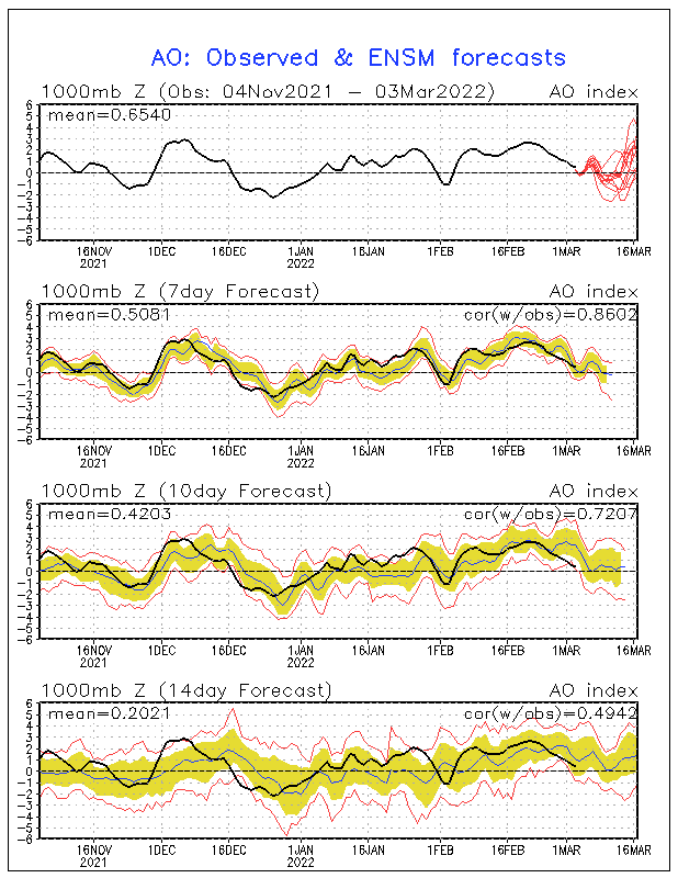
Now for the Long-range update that I have been promising. First let me explain what's happening. Right now, in the Central Pacific, a raging La Nina is underway, with the Nino 3.4 region experiencing values near -1.1 degrees Celsius (note: these values are anomalies and not represent actual temperatures. Actual temperatures in this region are near 70 degrees Fahrenheit.). Over the last few weeks, this area of below normal sea surface temperatures has spread westward, causing a basin-wide La Nina. This is what we had last winter, which means we should start seeing the weather pattern become closer to what happened last year, especially by the end of January. One thing that has surprised many meteorologists is the fact that the SOI values have really dropped, even though the La Nina has in fact strengthened. As explained in previous posts, SOI stands for Southern Oscillation Index. When the index is positive, a La Nina is underway, because the pressure difference between Tahiti and Darwin, Australia is positive. When the index is negative, an El Nino is indicated. The daily values for yesterday and the day before have been sharply negative, which is not a good sign for the rest of the winter. If these negative values continue for a lot longer time, expect the La Nina to weaken significantly, and in fact reverse to an El Nino by the middle of March or April. This would cause a lot less precipitation over the area, which is really bad news for snow lovers in the Ohio Valley. Right now, this scenario does not look at all likely, mainly because these negative values may be because of the westward expansion of colder than normal waters in the equatorial Pacific. In fact the most likely scenario right now is that the La Nina may be actually strengthen a bit before the end of January, before beginning a gradual weakening trend. The CFS climate model is forecasting the continued strengthening of a moderate La Nina to a strong La Nina, with the La Nina becoming stronger after July. This would mean, a very snowy end to winter, even if temperatures are above normal (not taking into account the pattern change). On the other hand, the CFSv2 model (an enhanced version of the CFS model) is forecasting the La Nina to remain steady or slightly strengthen before the end of January, and then it it is forecasting a rapid weakening of the La Nina, becoming neutral by May and becoming an El Nino by July or August. The most likely forecast is a combination of these models' forecasts, with a moderate strengthening of the La Nina through February or March, with a rapid weakening beginning in March, becoming neutral by July and possibly becoming El Nino by the beginning of next fall. This will cause continued above normal precipitation and snowfall. Another factor that I am taking into account is the teleconnections, which affect the position of the jet stream. The NAO, which stands for North Atlantic Oscillation, is an index measuring the difference between observed sea level pressure between the Azores and Iceland. When it is positive, a strong low pressure center is positioned over Iceland, when it is negative, high pressure is located over Iceland. The positive phase tends to bring warmer than normal conditions to North America and Europe, while the negative phase tends to bring widespread cold and snowy conditions to North America and Europe. Right now, ensemble forecasts have the NAO becoming negative especially after January 16th. This will finally allow winter to return to the United States. The next teleconnection, which is very closely related to the NAO, is the Arctic Oscillation or AO. When it is in a positive phase, stratospheric temperatures become very cold over the Arctic, while in the negative phase stratospheric temperatures become much above normal. When it is in its negative phase, cold, Arctic air is pushed southward out of the Arctic, causing brutal winters over the United States and Europe. When it is positive, warm air dominates both continents, as a strong low pressure system dominates the Arctic, keeping the arctic air "locked up". Ensemble forecasts show general agreement that the AO will go strongly negative by about January 16th, with the lowest values since December 2010 showing up. This will finally allow winter to return to the United States, with several snowstorms possibly in our area after the mid month. In fact, we could see some hefty snowstorms by February. But for now, expect to be in a transition phase, with a more turbulent pattern before this happens. One sign that shows this might actually be happening is the fact that a Significant Stratospheric Warming event is occuring, which is the tell tale sign of the weakening of the Polar Vortex, a major factor that has kept cold air out of the area throughout most of the winter. In the lower stratosphere, over the past few weeks, temperatures have warmed from much below normal back in mid December, to well above normal in only a few day's time. When significant warming in the stratosphere occurs above the Arctic, a disruption of the powerful polar vortex occurs. The polar vortex is just the meteorological term for the very center of the brutal arctic air. If this vortex weakens, that means that the cold, arctic can finally come rushing out of Canada, and stay in the United States. Even though significant warming has occurred, the atmosphere usually takes a couple of weeks to respond to this burst of warm air. Therefore, we should be seeing the longer outbreaks of Arctic air into the air by the middle or end of January, and continuing shots of arctic air into February and early March. This will be something I will continue to monitor, so that an accurate forecast of arctic outbreaks can be made. As an example, next week, a powerful cold front (just about as powerful as last Sunday's) will push through the area, dropping temperatures from the lower 50's to the lower and mid 20's by Friday of this week, with heavy lake effect snow returning. This cold air will likely retreat after a several days, but there will not be as much warming as with the last time. In fact, the Climate Prediction Center is forecasting that a large trough will dominate the country for the rest of the month, leading to frequent arctic outbreaks and rather stormy weather to persist across the Ohio Valley. This may bring our first real snowstorms by the end of January.
Subscribe to:
Posts (Atom)