Areas along the Great Lakes would
see above normal lake effect snowfall. Anywhere else in the Ohio Valley
and Midwest would likely see a lack of precipitation and thus snowfall.


The ENSO phase and It's Development
As I have stated in the previous post, my findings and conclusions were this yesterday: One; That the best matches for the year's forecast were the years of 2006, 1993, 1981, 1976, 1969, and 1966... There are a few other years, and I'm changing them.. Even those these years are the closest in the weather patterns, they are actually quite far from what we are experiencing.. This is the first year that I have made a winter forecast (this is my third year) where the year in question did not have even a close match... So, this one may go on intuition. One of things I would like to emphasize in this update is the ENSO pattern (tomorrow's update will feature atmospheric blocking and SSW's).. Across the Equatorial Pacific, the current El Nino is dying.. According to Climate Prediction Center charts, the above normal SST anomalies have been fading away over the past several months, and shifted westward, as the thermocline in the equator region moves upward (the dividing line of colder waters located about 200 meters below the surface of the ocean.)... This is associated with an increase in upwelling and thus a closer La Nina pattern. I would not be surprised to see a neutral pattern come in for the winter period, or even a weak La Nina. On average, most neutral ENSO winters feature above normal snowfall across the region, but colder than normal temperatures. But that all depends on other factors such as atmospheric blocking across the North Atlantic (which I will explain in tomorrow's post). Another factor that is contributing to the weakening of the El Nino is the fact that atmospheric wind and precipitation patterns are not responding. First of all, the trade winds have not really backed off (while they are weaker than last winter's trade winds, but that was brought on because of the original intensification of the short-lived El Nino back in July), and this is the reason for the westward advancement of the above normal sea surface temperatures.. For an El Nino to strengthen it needs to stay in the eastern ENSO zones. Other factors, such as a very strong negative PDO regime is likely affecting the development of the El Nino.
What this means is that this winter will likely not reflect El Nino weather patterns, which on average would usually mean above normal temperatures across this region, but with drier than normal weather. I expect with a farther north southern jet stream, that precipitation will likely be above normal. Right now, temperatures look to be the wild card. I will have this resolved by the time I have next week's article published. Until then, here are my current thoughts. If the ENSO event does turn into a weak La Nina or even stay neutral, I expect temperatures to be slightly below normal across the region. If the ENSO strengthens into a stronger El Nino, then I would expect near or slightly above normal temperatures for the region.

Some thoughts...
Some
additional thoughts on this winter's outlook... Last winter as most of
us recall, featured rather warm temperatures. This was in part due to
the lack of cold air in Canada (it was also a rather warm year in
western and Central Canada), and the fact
that there was virtually no atmospheric blocking across the North
Atlantic. Towards the latter half of the winter season, an SSW occurred
over the Arctic regions. An SSW stands for Sudden Stratospheric Warming
event. In theory, an SSW should lead to increased atmospheric blocking
over the North Atlantic or the Arctic, approximately 2-4 weeks after the
SSW has occurred. Last winter, it came too late, as very little
extremely cold air had built up over western and central Canada. When
conditions were favorable over Alaska for the build-up of a record
breaking cold air mass, the jet stream patterns became unfavorable for
the movement of this arctic air mass into the Eastern United States.
This year, over the course of the spring and summer months, strong
atmospheric blocking has set up across the North Atlantic. In fact, we
just recorded the lowest NAO value on record back in June (Climate
Prediction Center).. Right now, positive stratospheric temperature
anomalies have been building across the North Pacific and Arctic
regions, possibly in correlation with the strengthening negative PDO
regime. This has lead to a drastic drop in NAO values over the past week
or so, and the reason for the cooler weather. IF this pattern can stay
in place for the next couple of months, it could possibly become the
main winter weather pattern. This kind of a pattern would be very
favorable for extremely cold winter weather, but drier conditions across
the Northern U.S. Another signal I'm looking at is the ENSO conditions.
If the CFSv2 long range forecast is correct (the first set of ensemble
members), then the El Nino will weaken considerably by December, and
become neutral. This remains consistent with the fact that El Nino's
usually struggle to develop in the negative episode of the PDO. Of
course I am still investigating this winter, and I will provide more
updates as the week goes on, but at this point, there are three possible
weather patterns that this winter COULD feature: One, a rather warm,
and possibly wet winter associated with the El Nino (similar to
2006-2007). Two, a rather cold and dry winter, similar to the winter of
93-94. And three, a winter similar to 2010-2011 where the negative PDO,
intense atmospheric blocking, and positive PNA patterns dominated and
caused a rather cold and snowy winter. The most likely winter weather
pattern at this point is number one, mainly based on historical
analogues. After reviewing the data, this year is very unique in the
fact that virtually no years in the historical record from 1951 onward
even come close to having similar weather conditions to this summer and
fall. This may be a rather unique winter season, and quite a bit
different from the last winter season. I will discuss this in a related
post tomorrow.
All in all, the most likely scenario for the
winter is one that features near or slightly above normal temperatures,
and likely above normal precipitation (given a strong southern jet
stream, which will average farther north than normal)..

2012-2013 Preliminary Technical Outlook
I will have to review more data for the upcoming winter.. But I should
be finished by next weekend. I will also publish the forecast in the
paper.
As for what my preliminary thoughts are.. Based on the past winters, I expect that December could end up rather warm or just slightly above normal temperature wise, with near or slightly above normal precipitation (given an active southern jet stream that could be slightly farther north than on average.).. By January, the NAO (North Atlantic Oscillation), could drastically change after taking a brief dip into positive territory, and taking a sharp dip into the negative index values. I'm basing this off of the fact that in recent years, the NAO has been drastically changing and to near opposite ends of the spectrum over a time period of a few months... Take for instance this past summer and spring, we had one of the lowest values of the NAO on record. I believe this to be in part influenced by one of the lowest solar activity periods in the records. What could happen is that it will likely drop again this winter, leading to a much colder end to the winter season. By February, temperatures will likely remain cold...
This is only preliminary, and if El Nino decides to strengthen rapidly, all of these ideas will be null and void. I expect several updates on the winter forecast this fall.
2012-2013 Preliminary Winter Temperature Outlook
As for what my preliminary thoughts are.. Based on the past winters, I expect that December could end up rather warm or just slightly above normal temperature wise, with near or slightly above normal precipitation (given an active southern jet stream that could be slightly farther north than on average.).. By January, the NAO (North Atlantic Oscillation), could drastically change after taking a brief dip into positive territory, and taking a sharp dip into the negative index values. I'm basing this off of the fact that in recent years, the NAO has been drastically changing and to near opposite ends of the spectrum over a time period of a few months... Take for instance this past summer and spring, we had one of the lowest values of the NAO on record. I believe this to be in part influenced by one of the lowest solar activity periods in the records. What could happen is that it will likely drop again this winter, leading to a much colder end to the winter season. By February, temperatures will likely remain cold...
This is only preliminary, and if El Nino decides to strengthen rapidly, all of these ideas will be null and void. I expect several updates on the winter forecast this fall.
2012-2013 Preliminary Winter Temperature Outlook
This is a map that I have compiled of my
analogue years for the winter... The winter's used are 2006-2007,
1993-1994, 1969-1970, 1966-1967...
This would indicate a colder than normal winter for the region, but with precipitation near normal with snowfall above normal... I'm not sure if this is going to pan out, but this is the best I can do based on history.

Technical Winter Outlook DiscussionThis would indicate a colder than normal winter for the region, but with precipitation near normal with snowfall above normal... I'm not sure if this is going to pan out, but this is the best I can do based on history.

As many of you have probably read my winter forecast, I expect you have a few questions as to why I'm predicting what I am. In this discussion I will give my major reasons for the forecasts, and a few other almost non-significant reasons as to why I made this forecast. I am also including month by month outlooks, which will give details on things such as temperature, storm potential, snowfall amounts, and any warm ups. By mid to late November, I will have a refined forecast, which will explain the month by month setup even more, along with storm track potential and when we can expect our first major winter storm in this region. For now, let's get on with the discussion.
The first major factor (and probably the most important of them all), is the fact that yet another La Nina is developing in the equatorial Pacific. Currently, the Climate Prediction Center has upgraded their La Nina Watch last month to a La Nina Advisory this month in their latest ENSO outlook. According to the latest analysis, the CPC (Climate Prediction Center) explains that the current La Nina is not near as strong as it was during September of 2010. This proves the fact that this year's La Nina will probably not be as strong as last year's. But over the last few weeks, La Nina conditions have been developing very quickly, with current La Nina conditions at about -1 degrees Celsius, which is way below September's ENSO index, which was only -0.6 degrees Celsius (note, when I refer to negative degrees celsius, I mean below normal and not as an actual temperature. Actual temperatures in the equatorial Pacific are about 18 degrees Celsius.). This value of the ENSO index indicates a border-line moderate La Nina. According to the latest underwater temperature anomalies, there is still a very large region of much below normal water temperatures upwelling to the surface from about 100-200 meters below the surface of the ocean. Most of these below normal water temperatures are occuring in the eastern and central regions of the Equatorial Pacific. I will explain the significance of this later in the discussion. Along with the factors that are promoting La Nina, I expect still declining SST anomalies, allowing for the strengthening of the La Nina. I would expect the La Nina to level sometime in late January 2012 or early February 2012, at a peak of about -1.4. In fact, this value may change because according to several of the NCEP's climate forecasting models, values may reach or exceed the ENSO index value of -1.5, with the CFSv2 forecasting a peak of about -2.0. A value of -2.0 would indicate one of the strongest La Nina's on record. But I really think the CFS's idea of this low of a value is almost farfetched, as current ENSO index levels are not nearly as strong as in 2010 at the same time, and we leveled off just before we could reach Strong La Nina values. So, in conclusion, I expect the peak of the La Nina to be at -1.4, which is the exact same as last year. Now back to talking about what east based and west based La Nina means. In a west-based La Nina, which hasn't happened in several years, the coolest and most concentrated cool waters are located over the western equatorial Pacific, is almost similar to what happens during an El Nino. Generally, west-based La Ninas cause a very strong ridge to form during the winter months over the East. This causes much above normal temperatures to extend back into the Plains states, who would normally bring significantly cool temperatures to the plains. During west-based La Nina winters, the Ohio Valley and Great Lakes would see plenty of precipitation, but not much in the way of snow. They also tend to reduce Lake effect snowfall amounts. During east-based La Ninas, widespread below normal temperatures occur over much of the U.S., excluding the Southeast and Florida. Precipitation is also above normal from the Great Lakes and Ohio Valley on toward the East Coast. Here are some maps to illustrate what I just explained.
The first major factor (and probably the most important of them all), is the fact that yet another La Nina is developing in the equatorial Pacific. Currently, the Climate Prediction Center has upgraded their La Nina Watch last month to a La Nina Advisory this month in their latest ENSO outlook. According to the latest analysis, the CPC (Climate Prediction Center) explains that the current La Nina is not near as strong as it was during September of 2010. This proves the fact that this year's La Nina will probably not be as strong as last year's. But over the last few weeks, La Nina conditions have been developing very quickly, with current La Nina conditions at about -1 degrees Celsius, which is way below September's ENSO index, which was only -0.6 degrees Celsius (note, when I refer to negative degrees celsius, I mean below normal and not as an actual temperature. Actual temperatures in the equatorial Pacific are about 18 degrees Celsius.). This value of the ENSO index indicates a border-line moderate La Nina. According to the latest underwater temperature anomalies, there is still a very large region of much below normal water temperatures upwelling to the surface from about 100-200 meters below the surface of the ocean. Most of these below normal water temperatures are occuring in the eastern and central regions of the Equatorial Pacific. I will explain the significance of this later in the discussion. Along with the factors that are promoting La Nina, I expect still declining SST anomalies, allowing for the strengthening of the La Nina. I would expect the La Nina to level sometime in late January 2012 or early February 2012, at a peak of about -1.4. In fact, this value may change because according to several of the NCEP's climate forecasting models, values may reach or exceed the ENSO index value of -1.5, with the CFSv2 forecasting a peak of about -2.0. A value of -2.0 would indicate one of the strongest La Nina's on record. But I really think the CFS's idea of this low of a value is almost farfetched, as current ENSO index levels are not nearly as strong as in 2010 at the same time, and we leveled off just before we could reach Strong La Nina values. So, in conclusion, I expect the peak of the La Nina to be at -1.4, which is the exact same as last year. Now back to talking about what east based and west based La Nina means. In a west-based La Nina, which hasn't happened in several years, the coolest and most concentrated cool waters are located over the western equatorial Pacific, is almost similar to what happens during an El Nino. Generally, west-based La Ninas cause a very strong ridge to form during the winter months over the East. This causes much above normal temperatures to extend back into the Plains states, who would normally bring significantly cool temperatures to the plains. During west-based La Nina winters, the Ohio Valley and Great Lakes would see plenty of precipitation, but not much in the way of snow. They also tend to reduce Lake effect snowfall amounts. During east-based La Ninas, widespread below normal temperatures occur over much of the U.S., excluding the Southeast and Florida. Precipitation is also above normal from the Great Lakes and Ohio Valley on toward the East Coast. Here are some maps to illustrate what I just explained.
 z
Therefore, since this winter's La Nina is east-based I believe that temperatures over most of the Northern United States will be below normal throughout most of the winter. But making a forecast just based on one variable won't do you any good. So I went ahead and did research on the NAO. As I have explained in past articles, the NAO stands for the North Atlantic Oscillation, which indicates that it has to do with the wind patterns across the North Atlantic. How the Climate Prediction Center determines the daily NAO is by taking the 500 millibar height difference between the Azores and Iceland and comparing it to normal. If the 500 millibar height difference is large compared to normal, the NAO is considered to be positive. During positive phases of the NAO, the storm tracks shifts northward, because there is such a large difference in air pressure, the jet stream is very strong, allowing for many storm systems to form over Iceland and make their way into northern Europe. Generally, winters and summers with a dominate positive NAO will cause much stormier than normal conditions over most Europe in both seasons. A negative NAO, indicates that the 500 millibar geopotential height difference is smaller than average and the difference can sometimes be negative in some extreme situations. This situation allows the jet stream to take a more southerly route across the United States and a southerly route toward Europe. In these situations, the jet stream is weaker across the Atlantic, and causes extended cold, dry periods across all of Europe, and across the United States, the weather tends to be much colder than normal, and it causes a very snowy, stormy weather pattern across the Eastern U.S. According to trends in recent months, and over the last several years, I expect the NAO to continue a downward trend and become more predominantly negative during the winter months, allowing for below normal temperatures and above normal snowfall throughout much of the east. Scientists have also studied another index that strongly correlates to the NAO. This index is the AO. The AO stands for the Arctic Oscillation, and refers to the wind patterns and temperatures in the stratosphere over the Arctic regions. When the AO is positive, this indicates that stratospheric temperatures over most of the arctic region are much below normal. Much below normal temperatures over the Arctic create strong westerly winds in the Arctic stratosphere due to the large temperature difference between the poles and the equator. With a positive AO, atmospheric blocking in lower layers of the atmosphere is reduced, allowing for an extremely amplified pattern with a strong jet stream over the Atlantic. When the AO is negative, stratospheric temperatures over the Arctic are much above normal, causing above normal heights and weak easterly winds. These weak easterly winds cause a ridge of high pressure to form in lower layers of the atmosphere. This ridge of high pressure generally located over Greenland, will cause a road block in the normal westward wind flow. The jet stream will move so that there is a major trough over the east, and when both the NAO and the AO are negative, this can create the potential for major storms across the East, especially during the winter season.
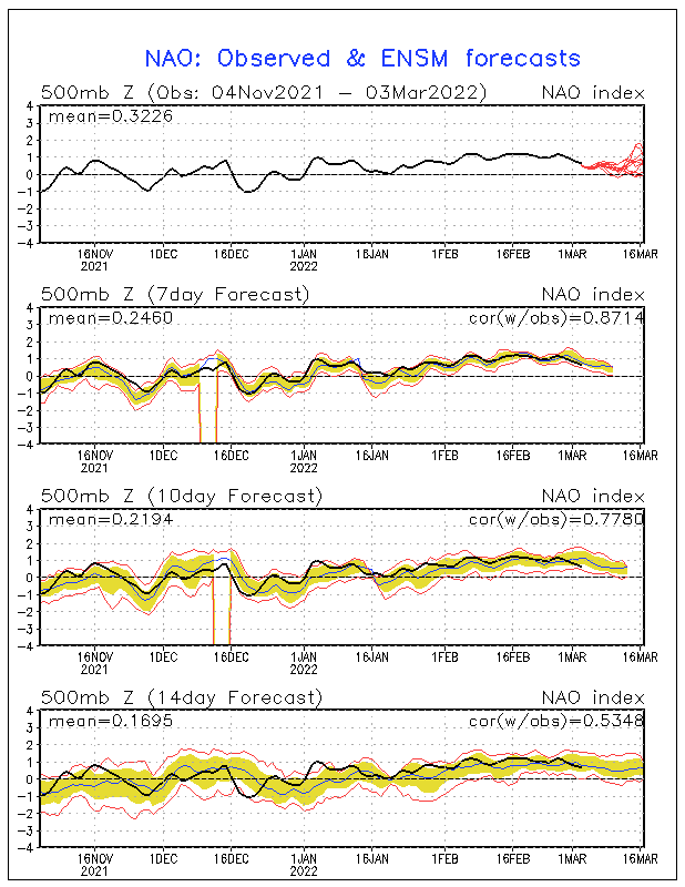
In actuality, I have read several articles about research being done on the NAO. They believe they have found a non-trending multi-decadal oscillation of the NAO. They have found that the NAO seems to have a thirty year cycle, going from mainly negative values to mainly positive values. They have found three such periods in the known record, extending back to the 1920's and 30's. From 1925 on to the 1950's, there was a positive period of the NAO, where only a few times was the NAO observed to have a negative value. During this same period in time, global temperatures increased. From the mid 1950's to the late 1970's, was an extended period of negative values of NAO, with only two months in the entire period having a positive value. During this time in earth's history, many of you probably remember the Great Ohio Blizzard '78 and the snowstorm in March of 1964, where Fort Wayne had their all-time greatest one day snowfall on record of 14.6 inches. During these years in earth's history, the average global temperature decreased and was actually about 0.8 degrees Celsius cooler than it was today. From the early 1980's onward to the late 1990's, the earth entered a very warm period, where temperatures the highest ever recorded in the 20th century, in 1998. In this same period of time, the NAO was in a predominantly positive phase, allowing for above normal warmth to spread farther northward. Currently we have entered a more stable phase of the NAO, where it has varied from year to year. In the last two years, scientists believe that we may have entered a negative phase of the NAO, as during the last two years the NAO has been predominantly negative.
The next variable I want to look at is the PNA. The PNA stands for Pacific North American pattern. Compared to the NAO and the AO, the PNA does not show any significant trends or cycles in the last one hundred years, and it is a very short term index. The PNA index refers to the height contour/pressure pattern from the Central Pacific coast to the Pacific Northwest and then towards the Eastern United States. If the PNA has a negative value, then there is generally a trough and stormy conditions hitting the West Coast, while the Southeast and East Coast enjoy mild conditions, while the Midwest is generally stormy. When the PNA has a positive value, a ridge is generally present over the West and a major trough is generally present over most of the East. Over the last several years, and especially during the past 10 months, the PNA has trended towards a positive value, indicating that this trend may continue into the winter months, but to a much lesser extent. This winter, I expect the NAO to remain negative more so than any of the other values I have been talking about. While I expect the NAO to continue to be negative, I do not expect it to be as extreme as last winter. This winter, the NAO will probably be slightly to moderately negative, indicating that the trough that will develop will be centered more so over the Midwest and Great Lakes, rather than the East Central states. The AO will more than likely average out to be only slightly negative, also indicating that the trough will be centered more so in the Midwest and Lower Great Lakes than in the East and Southeast. I expect the positive PNA values to be much less to an extreme, with values closer to zero. This should allow the trough to be centered more over the Midwest than last year.
I also used more indices in the development of my winter forecast, especially longer range values such as the PDO. PDO stands for Pacific Decadal Oscillation, which instead of dealing with pressure surfaces, it deals directly with sea surface temperature anomalies. Since it deals with temperatures, its value correlates much stronger with the Earth's weather than does the NAO, AO, and the PNA. According to research climatologists, they have found that the PDO has a distinct thirty year cycle, with which it varies from positive to negative. Even though the PDO has a thirty year cycle, it can vary from year to year especially in between significant ENSO events. During a negative PDO period, sea surface temperature anomalies are generally much below normal for the thirty year period for the oceanic region surrounding the Equatorial Pacific, while ocean regions of the Northwest Pacific experience much above normal temperatures. During a negative PDO period, east and central based La Nina's are more likely to form, especially stronger events, and as discussed above, east and central based La Nina's tend to bring cool temperatures to much of the Eastern United States during the winter months. Therefore, during the cool or negative phase of the PDO, much below normal temperatures are more likely across the east. During the warm phase of the PDO, warmer than normal temperatures exist near the equator in the Pacific, while cooler than normal waters exist across the Northern Pacific Ocean. This type of pattern allows El Nino frequency to increase, while La Nina events can happen and sometimes do happen, they are usually weak and west-based. Currently, we have just exited the last warm phase of the PDO in the late 1990's, and have entered a cooling phase of the PDO. As of 2011, PDO values are negative for the first time since the early 1980's. Over the last year, the PDO has really tanked, signally the start of the next cool phase in the Pacific. With this cool phase, expect frequent La Ninas, while United States winters get snowier and colder especially across the North. Also expect an increase in severe weather activity during the next thirty years, especially across the Ohio Valley. So what does the negative PDO mean for this winter? Well, I expect that a dropping PDO will cause a strengthening of the La Nina, and going with my forecast of a moderate to strong La Nina at that. Also, with the last negative PDO regime, (during the 60's and 70's), we saw some of the worst winters on record especially around here, where parts of the Corn Belt and Ohio Valley saw record cold and record snowfall. During the last year of the negative PDO, Fort Wayne had their snowiest winter on record, with 82.1 inches of snow falling during the winter season of 1981-1982. So this year, I would expect much above normal snowfall around here, with frequent bouts of arctic air into our area, as the jet stream will be positioned just to the south of our area.
 |
| Decadal averages of PDO values |
 |
| Solar sunspot activity |
With all of these factors in play, this may be the winter to buy a snow blower or new shovel especially if you live in the Ohio Valley, Great Lakes, and Northern Plains, as an extreme winter is forecast with heavy snowfall and colder than normal temperatures. In my next post, I will give month by month forecasts for the entire United States, based on these trends and indices
Detailed Winter Outlook 2011-2012
After listing off my reasons for the winter forecast, I will give a month by month outlook on what will likely happen this winter, including region-by-region forecasts. In general, wet and below normal temperatures will be persistent across the northern United States, while the South and Southwest will bask in sunshine for large parts of the winter, allowing for the Texas drought to re-expand. Across the Northeast and Mid-Atlantic states, I expect them to start off with below normal temperatures and frequent snowfall, but by late January and February, I expect a major warming trend, while the storm track remains over the Ohio Valley. In the Central Plains, I expect that frequent bouts of cold will hit the region, but precipitation and snowfall will be near to slightly above normal. Now for the details.
(Disclaimer : This forecast is subject to change and it could change drastically. Do not use this as a guide to the winter, as it may be wrong and you may solely be disappointed.)
November: I want to start out with the month of November, mainly because I think that unlike last year, this year's winter may start out by mid-November. November is looking a bit iffy for a forecast, but it looks like below normal temperatures will prevail across a good chunk of the United States, as the NAO goes negative by early to mid November. Many regions especially across the North Central Plains will likely see a couple of snowstorms during this time, while other parts of the Great Lakes and Ohio Valley will likely see the start of the Lake-effect season, especially after mid-November. There may even be some synoptic scale storm systems that bring accumulating snowfall to the Ohio Valley during this time as well. In the Northeast, this may be the perfect time for a Nor-easter to form, even though it will likely not be a snowstorm. Across the Southern United States, I expect near to below normal temperatures, along with below normal precipitation, causing the drought to intensify. Along the west coast, near to above normal precipitation will be the rule, as an active La Nina pattern settles in. Temperatures will likely be near normal to above normal.
December: During the month of December, I expect that winter will really set into the U.S., as bouts of arctic air and heavy snow fall across a large part of the East and Midwest. I expect temperatures to be much below normal (5-7 degrees below normal), from the Northern Plains, southward through the lower Great Lakes. This region of extremely cold air will cause the predominant storm track to follow the Appalachian mountains and the East Coast, allowing for the formation of a couple of Nor'easters, though not as severe as last year and the year before. Therefore I expect precipitation to be above normal in the Ohio Valley and lower Great Lakes east of Chicago, towards the East Coast, while snowfall will likely be above normal along the major east coast cities and in the Ohio Valley. Snowfall will likely be much above normal in the Lake-effect snowbelts. In the Southeast, temperatures will likely be below normal for this part of the winter, bringing the only chance of freezes for the season. Precipitation will likely be near normal to above normal which may help drought conditions some. Across Texas and Oklahoma, there could be some major ice storms along with the cold air, while southern Texas will likely above normal warmth and dry conditions. In the west, I expect above normal precipitation along the entire coast, and also some parts of the Southwest. Heavy mountain snows will be frequent as the Pineapple Express sets up shop once again this winter for a time.
January: During January, I expect temperatures to warm quite a bit as a weak southeastern ridge develops across Florida. This warmth should cause near normal temperatures along the eastern coast, with above normal rainfall and an increase in ice storms, especially in the Mid-Atlantic and lower New England. In the Ohio Valley and Great Lakes, I expect the cold temperatures to hold on, causing the temperature gradient to increase between the East Coast and areas west of the Appalachians, which should cause a very strong jet stream, and the potential for several blizzards and snowstorms especially from Chicago and Detroit southward towards Indianapolis and Cleveland. During this time, Lake-effect snow will dwindle especially around Lake Erie, as the lake freezes over quickly. Across the North Central Plains, very cold conditions will prevail, along with frequent snowfalls from Alberta Clippers. In the South, conditions should hold dry, with warm temperatures prevailing. This holds true for Texas and the Southern Plains. In the Southwest, very dry conditions will be present, as a ridge builds in this region also, along with much above normal temperatures. Along the west coast, I expect temperatures to be near normal, but with above normal precipitation north of central California. In the mountainous regions, expect above normal snowfall, as frequent heavy snowfall arrives in the mountains.
February: February should be the most dangerous month, as in heavy snowstorms for the Ohio Valley, Northern Plains, and Great Lakes regions, as I expect one or even two snowstorms to dump 1-2 feet on these regions. Temperatures during the month of February should cold but could moderate by the end of the month. Along the East Coast, conditions will probably be slightly drier than normal, as the storm track is displaced farther west from the region, and temperatures also be mild especially in the lower Mid-Atlantic states. Across the majority of the south, I expect below normal precipitation and above normal temperatures, with the exception of Alabama and Mississippi, who could see a very active start to the severe weather season, especially later in the month. In the west, I still expect a repeat of La Nina conditions, with frequent heavy rainfall, and frequent heavy mountain snows. In the northern plains, I still expect a continuation of the cold, but with more snowfall than in previous months.
What this means for Northwest Ohio and Indiana: December: temperatures will be much below normal, with frequent lake-effect snows west of the area, with some lake effect snow affecting our area. December may seem dry, until a major storm at month's end could bring copious amounts of snow to the area, especially in Northwest Ohio.
January: temperatures moderate some, not as cold as December, but still below normal (2-4 degrees below normal). Clipper systems will be more frequent in the beginning of January, but will transition into major Colorado lows and Gulf lows, that will bring frequent heavy snowfall by the end of January. Lake-effect snow will likely dwindle, unless Lake Michigan does not freeze over. Major snowfall amounts.
February: temperatures will continue to moderate as storm track shifts westward slightly. Once again, I expect major snowstorms to hit the area, with maybe a snowstorm bringing a good 1-2 feet of snow to the region. Ice storm frequency may increase by months end. Temperatures will be slightly below normal to near normal especially by month's end.
Second Official Winter Forecast
In this forecast, I do not want to get very technical, so I will get straight to the point in each region. If you want to know why I made the forecast the way it is, go to my blog for additional info as I will explain the method to my madness. I will make a forecast for each of six regions, with month by month details on my blog. These regions are as follows: Northeast (including the Mid-Atlantic states), the Southern U.S., the Southwest, the West Coast (Pacific Northwest), the Rockies and Upper Midwest, and the Great Lakes/Midwest/Ohio Valley region. I will begin with the Pacific Northwest and West Coast. As is typical with a La Nina winter, I expect quite a bit of winter precipitation in the Pacific Northwest, including Washington state, Oregon, Idaho, and parts of Montana. In actuality, the train of storm systems that normally comes with a La Nina winter has already begun in the Pacific Northwest, as the ridge has finally left the west, allowing for a major trough to bring in multiple rounds of storm systems to the West. In the mountainous regions, I expect a very long and successful skiing season, as snowfall amounts will be extreme in the Cascades, the Sierra Nevadas in California, and for most of the Rockies north of Colorado. With all of this precipitation, comes below normal temperatures to most of Washington state and Oregon, with regions south of these states, having near normal temperatures for most of the winter. In the Southwest deserts, I expect for the most part dry and relatively mild conditions for the winter. This will allow for the drought to re-expand westward from Texas, and raise water concerns for the second winter in a row. Even with overall drier than normal conditions for the season, during December, as mentioned above there could be period where the Pineapple Express re-opens. The Pineapple Express refers to a theoretical atmospheric river of moisture that runs northward every once and a while into the West Coast of the United States. This "atmospheric river" brings very heavy rainfall for days and even weeks on end to Southern California and Arizona. I expect this to open up at least once this winter as it did last winter. In the Southern United States from Texas on over to Georgia and Florida, I expect almost the same thing as I do for the Southwest, with much drier than normal conditions and very mild conditions, especially later in the season towards mid-January through the spring months. Because of La Nina, I would also expect an early and active severe and tornado season throughout February and March, which could impact the same areas that were hit hard last year. Even though the south seems like it could be devoid of winter weather, don't let your guard down, because there could a few storms that will bring some extreme icing situations to areas such as Oklahoma and Arkansas eastward towards Tennessee, northern Alabama and Georgia, and western parts of the Carolinas. These storms could bring major power outages along with hazardous road conditions for days. The most probable time for these to happen will be in December and early January. Also, expect the drought conditions to spread eastward from Texas during the winter months. For the next region, the Northeast, I only have to say, that this winter will probably bring a much needed break from major snowstorms and blizzards. I expect near normal temperatures with above normal precipitation. Though, do not let your guard down, as there may be a significant blizzard and snowstorm that sneaks its way up the East Coast, and bring one of the only major snowfalls of the season to most areas especially south of New York City and Hartford, Connecticut. Areas north of here may experience more snowstorms and a lot more cold air than coastal southern areas. After mid-January, due to the development of a stronger Gulf of Mexico ridge, and due to warm onshore air flow, I expect some warming to occur especially in coastal areas, where by February, most of their precipitation will be heavy rains from storm systems. In the interior northeast, temperatures will likely not warm very much or they may not change at all from the previous cold temperatures as the Appalachian mountains will likely keep the warm Atlantic air mass from moving to much farther westward. Winter over the interior Northeast will likely be severe, as very cold air moves into the region from the Arctic, and as major storm systems move along the Appalachian mountains, creating many situations where heavy snowfall is possible. As for the Northern Plains and Rockies, I expect snowy and the coldest conditions of anywhere in the United States. All winter long, I expect an arctic air mass to remain in place, allowing for temperature departures from normal to be near -5 to -7 degrees below normal. With the jet stream coming out of Canada from the northwest, I also expect a snowier than normal winter with multiple threats of snow from Alberta Clippers which generally bring strong winds, heavy snowfall and bitter cold. There may also be one or two Panhandle hooks, which swing into Texas, and then make a sharp turn toward the north and generally bring blizzards to the Northern Plains. Now, finally, for the worst forecast of them all, the Ohio Valley, Great Lakes, and Midwest regions. In this region, all of the climatic variables seem to be pointing to a very snowy winter, with very cold conditions throughout most of the winter also. The predominant storm track will be through Kentucky, Tennessee and West Virginia during most of the winter, meaning that most of the Ohio Valley and Great Lakes will mostly see snow during the winter months. Because these storms will have access to moisture from the very warm waters of the Gulf of Mexico, allowing for the formation of very heavy snowfall with several storm systems. This year, we may actually see some classic blizzards over the area that dump over a foot of snow, and not just once but several times, especially in mid January through mid February. There may also be some Alberta Clippers that bring widespread snowfall amounts of 3-6 inches, but most of these will occur in December. With the heavy snowfall we could also see some very cold air arrive and stick for most of the winter. Temperature departures may be as low as six degrees below average for December and January. There is the possibility of a slight warm-up occurring during the month of February, which could lead to the possibility of an ice storm leading to hazardous roads and power outages. Along with the cold arctic air, the Lake-effect snow will be substantial once again, as the Great Lakes water temperatures are much above normal and I expect much of this heat to be retained throughout the winter. This will allow for multiple outbreaks of heavy lake-effect snow, which will cause much above normal snowfall in all lake effect snowbelts right along the Great Lakes. Northwest Ohio may even see some of this snowfall especially during some of the stronger outbreaks in December!
Overall, I see an extreme winter for a large portion of the Northern United States, leading to heavy snowfall and very cold air to much of the region. In many ways I expect this winter to be very similar to last year, expect for the fact that I don't believe the Northeast will have near the amount or strength of winter storms from last year, and I expect the heaviest snowfall to fall in the lower Great Lakes region, a belt from Chicago and Detroit on down to Indianapolis and on over to Cleveland. If I were you, I would prepare now for a very dangerous winter. Even though the forecast could change dramatically over the next month, and we could end up having very little snow. But, right now, this is the most likely to happen, given how the climatic signs and forecasts are lined up.
First Official Winter Forecast
After three months of very hot weather here in Northwest Ohio, your all probably wondering what will happen this fall and winter. Well, I have finally compiled my own forecast for the coming four months, based on ENSO conditions, Pacific Multi-Decadal Oscillation, NAO, and analog past years. Since Accuweather nor NOAA has succeeded with coming up with a seasonal forecast, for this fall or winter, I was forced to do quite a bit of research and insight. As a side note, this is only a preliminary forecast, do not treat this as official or as accurate, because a lot of things may change before this fall/winter season begins. Much of my research was done with the Climate Prediction Center's forecasts for ENSO, NAO, and the Arctic Oscillation. Some of it is based off of trends that have been observed in the last several winters and over the last year and a half.
In the last month and a half, the Climate Prediction Center has issued multiple forecasts on ENSO, and they have finally issued something called a La Nina Watch. In the watch statement, the Climate Prediction Center expects near-neutral to slightly negative ENSO values to continue into late November and early December, which is quite a bit different last year (last year we had rapidly falling temperature anomalies in the Pacific leading to a very strong La Nina). This combined with La Nina like conditions still present over most of the North Hemisphere (abnormally strong jet stream over Canada, enhanced convection over Indonesia, drier than normal conditions over western South America, enhanced hurricane activity over the Atlantic Ocean, etc.), will result in the return of conditions similar to last fall and early winter. According to the La Nina watch, SST (sea surface temperatures) anomalies have been falling gradually in Nina region 3.4 and Nina region 4, which has lead the Climate Prediction Center's forecast to call for weak La Nina to return by December (-0.5 to -1.0 degrees below normal). Computer model ensemble forecasts are pointing to a gradual fall into La Nina conditions by November and December, with some computer models such as the CFS and the NCEP CFSv2 models trending toward moderate La Nina conditions by late December. Also, there is usually a historical tendency for strong La Ninas to be followed by slightly weaker La Nina. With all of this in mind, expect La Nina-like conditions to continue or amplify over the coming months. This means wetter than normal conditions in the Pacific Northwest, a drier Southern US (which is really bad news for the areas in the exceptional drought currently ongoing across a large portion of the Southern US, this will help it become one of the worst droughts ever recorded. For more information on the drought visit http://droughtmonitor.unl.edu/.), very wet conditions for the Ohio Valley and adjacent Great Lakes, very warm temperatures across most of the Southern U.S., and no climate inclinations over the Northeast (keep in mind that these forecasts are for the months from December through February, and are not in any way forecasts for this fall.) Another major factor in my winter forecast is the North Atlantic Oscillation. This factor determines where and how strong the jet stream will be positioned over the North Atlantic and North America. Generally, during positive periods of the NAO, there is a strong 500 millibar ridge over the central Atlantic, with strong above normal geopotential heights, while over the Iceland there is a strong 500 millibar trough with much below normal geopotential heights. This situation will lead to a strong south-north pressure gradient and a very strong jet stream blowing from North America across the the North Central Atlantic toward Europe. This leads to cool, wet periods during the summer and mild, stormy periods during the winter over Europe. Generally the NAO does not have much of an effect over North American weather patterns during the summer. In the strong negative phase of the NAO, there are generally above normal geopotential heights near Iceland and Greenland (indicating an upper level ridge) and below normal heights and a much weaker pressure gradient between the central Atlantic and Iceland. This type of pattern causes the jet stream to be obstructed well to the north and causes it to move through Greenland and Iceland. During the winter this causes a major trough across the Midwest and Eastern United States, leading to extreme cold and snow. The same thing also happens in Europe. One thing about the NAO is that it can be never be predicted that accurately more than three weeks in advance. But many meteorologists when making a long-range forecast with the NAO, look for trends and patterns that could help predict what the pattern will be like in the next several months. Over the last three years, the NAO has been predominantly negative, which explains the cold winters and giant snowstorms for the East. I'm going to stick with the fact that the NAO will continue to be negative for this winter. Also, the NAO has been predominantly negative this summer. Therefore, I believe that this pattern will continue, leading to me to believe that a trough will dominant the winter pattern ( but not as strong of a trough as last year, as the NAO has been closer to neutral this year).
With these two major factors in play, I believe that this winter will be quite similar to last winter. Mainly because of a developing La Nina, present La Nina-like conditions, the forecast of a predominantly negative NAO, I believe that many parts of the US will not receive a break from frigid and snowy winter weather. Even the places that don't receive extreme weather (such as Texas, Oklahoma, and New Mexico) will still be in exceptional drought, and with a new La Nina developing, drought conditions will get worse. Let's start with the West Coast. Due to La Nina conditions, the much of the West Coast (from Central California on northward) will be very wet again, with below normal temperatures allowing for another great skiing season across the Sierra Nevada and the Cascades. Expect major spring and summer flooding in 2012. In the Rockies and Northern Plains, I would expect another snowy year but with the storm track shifted south of the area and how deep the area of below normal temperatures is expected to be, I would only expect the heaviest snowfall to be during December and March. Temperatures will again be much below normal across the Northern Plains and Rockies. In the Ohio Valley and Great Lakes, the jet stream expected to remain over this area throughout the winter mainly because of a developing ridge in the southeast part of the United States. This region will be extremely wet and snowy throughout the winter with frequent cold outbreaks, but not to the extent of last year's frigid temperatures. Spring flooding will be prevalent again and along with still wet soils could produce another major Mississippi flood in Spring 2012. Over the Northeast and Mid-Atlantic Coastline, I am expecting below normal temperatures for the northern half of the region, while the southern half (south of Pennsylvania) will experience normal temperatures to above normal in extreme southern sections. Precipitation will more than likely be above normal for this region as the jet stream will ride right through the middle of it. Several major Nor-easters could develop again this year, bringing much above normal snowfall to areas from Washington D.C. To Boston, MA. Across the South (from Georgia and Florida to Texas), drier than normal conditions will prevail due to the already dry soils and a ridge that is expected to develop over the southeast. This will cause the exceptional drought to spread to Georgia and Florida, and leading to more wildfires. Temperatures will also be warmer than normal, which will not help the situation at all. Occasionally there could be a significant storm system that could bring northern parts of the south winter precipitation (sleet, freezing rain, snow), but they would be much more likely over Arkansas, Oklahoma, Missouri, and Texas. Finally, in the Southwest, temperatures are expected to border line normal and above normal, mainly because of drier than normal conditions. I expect drier than normal conditions to expand across the Southwest causing a redevelopment of the drought in many areas. Only northern parts of the Southwest (central California, the Sierra Nevada) are expected to receive above normal precipitation.
