Come visit our Weather Analysis Page, where you can find all sorts of information. This page has the most recent analysis's for your usage. If you want to know what the weather's going to be like before you have to go your job, stop by the weather page and look at current radar and the positions of weather fronts, so you know what you can expect for the day. Come try it right now! Our new weather model and forecasting page will be added by tonight or tomorrow.
Saturday, December 3, 2011

Snowstorm potential grows.
The latest 12z run of the GFS has shown that as much 6-8 inches is possible over Northwest Ohio and some parts of Northeast Indiana. This is a large upward in the original snowfall amounts that the GFS was forecasting last night, up from one inch around here. Right now, the heaviest snow according to this model will fall right along the U.S. 24 corridor, extending back to about Fort Wayne, Indiana. IF the next couple of runs from the GFS show this much snow or more over the same areas, I would have to say our snowstorm potential grows. Then again, all of the other models are all over the place with this storm. The NAM has heaviest snow totals from North Central Indiana through southern Michigan with only about an inch or two for around here. The 00z run of the GFS was only showing a trace of snow around here. In reality, I believe this event will be almost exactly like what happened last week. One thing that cause this storm to be a bit different is the fact that this storm will be moving from the Southern Plains, drawing in arctic air on its north side, instead of Pacific air. This means that snow potential could be much more than last week. If the cold air is drawn farther east with this storm, I expect that the storm system will shift to the southeast, making for an even better snowstorm for this area. If the NAM and ECMWF verify, we would likely get around an inch of rain Monday, along with rain changing to short period of heavy snow Monday Night, and around an inch or two of accumulation, while areas just to the north and west will receive abundant amounts of snow, possibly over a foot in some areas. I will keep you updated as more data comes in.
 |
| Latest GFS Snowfall predictions. |
Another Complex Storm System.
Well, after the storm system that hit earlier this week, with heavy rain, high winds, and transitioning to heavy thundersnow, it seems as if the weather pattern will be repeating itself, but in a much different way. First of all, I want to show you the analysis maps, to show you where the systems are located and what they will do.
Now I will explain each of these maps, so that you will understand my forecast. The first map was a surface map. The lines that curved on the map are called isobars, or lines of equal pressure. Therefore, by looking at the surface map, you can determine areas of high pressure systems and low pressure systems. As you can see the initial surface low located over New Mexico, is very weak with only a central pressure of 1014 millibars. Computer models are currently forecasting this low to strengthen some, but not much, to a central low pressure of 1008 millibars. Even so, this will low pressure system will still produce quite a bit of precipitation over the next couple of days for many areas, even here (Oh, great!). Some of this precipitation will be snow over the Central Plains and Midwest. The heaviest snow will likely fall from northwest Kansas northeastward through Iowa, and into northern Michigan, with as much as 10 inches of snow. This will probably be a quick moving system, with rain moving into our area by late tonight, or possibly even late this afternoon, depending on the dryness of the air.
Now I will explain each of these maps, so that you will understand my forecast. The first map was a surface map. The lines that curved on the map are called isobars, or lines of equal pressure. Therefore, by looking at the surface map, you can determine areas of high pressure systems and low pressure systems. As you can see the initial surface low located over New Mexico, is very weak with only a central pressure of 1014 millibars. Computer models are currently forecasting this low to strengthen some, but not much, to a central low pressure of 1008 millibars. Even so, this will low pressure system will still produce quite a bit of precipitation over the next couple of days for many areas, even here (Oh, great!). Some of this precipitation will be snow over the Central Plains and Midwest. The heaviest snow will likely fall from northwest Kansas northeastward through Iowa, and into northern Michigan, with as much as 10 inches of snow. This will probably be a quick moving system, with rain moving into our area by late tonight, or possibly even late this afternoon, depending on the dryness of the air.
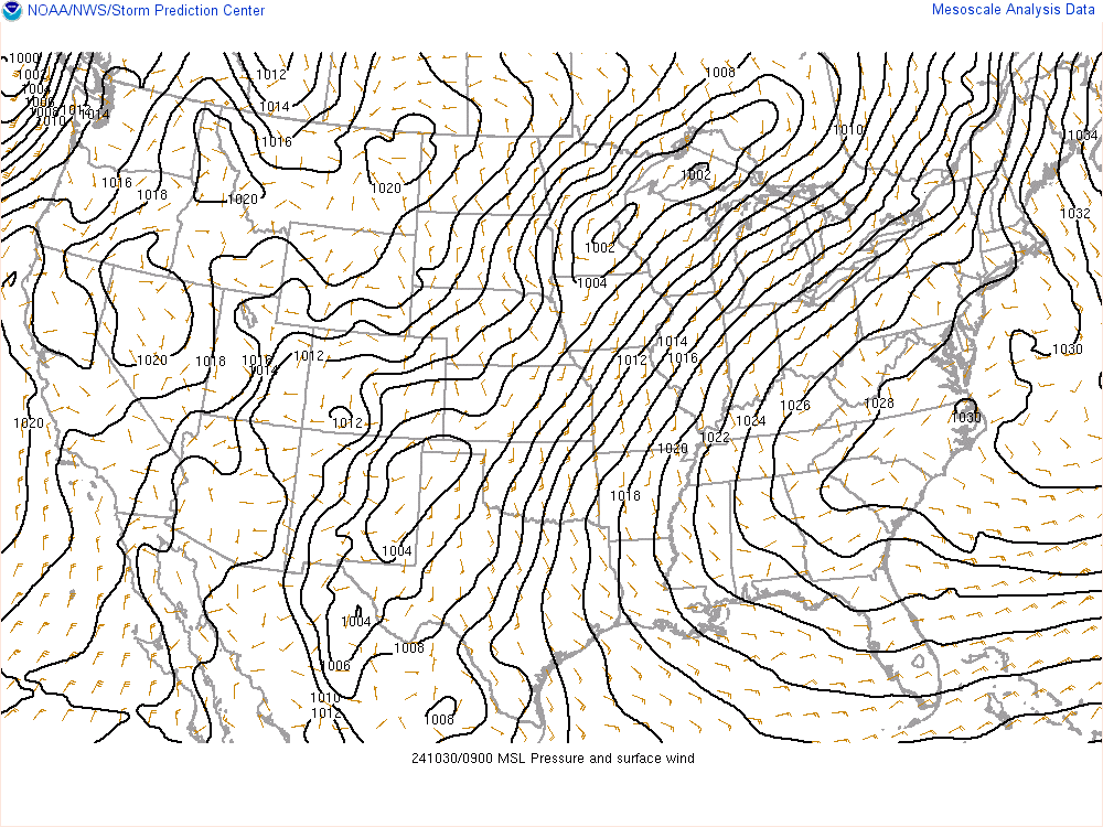 |
| Surface pressure and wind map |
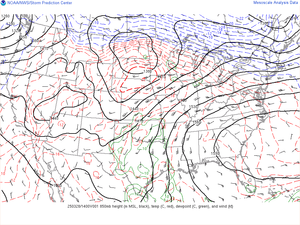 |
| 850 millibar temp and dew point map |
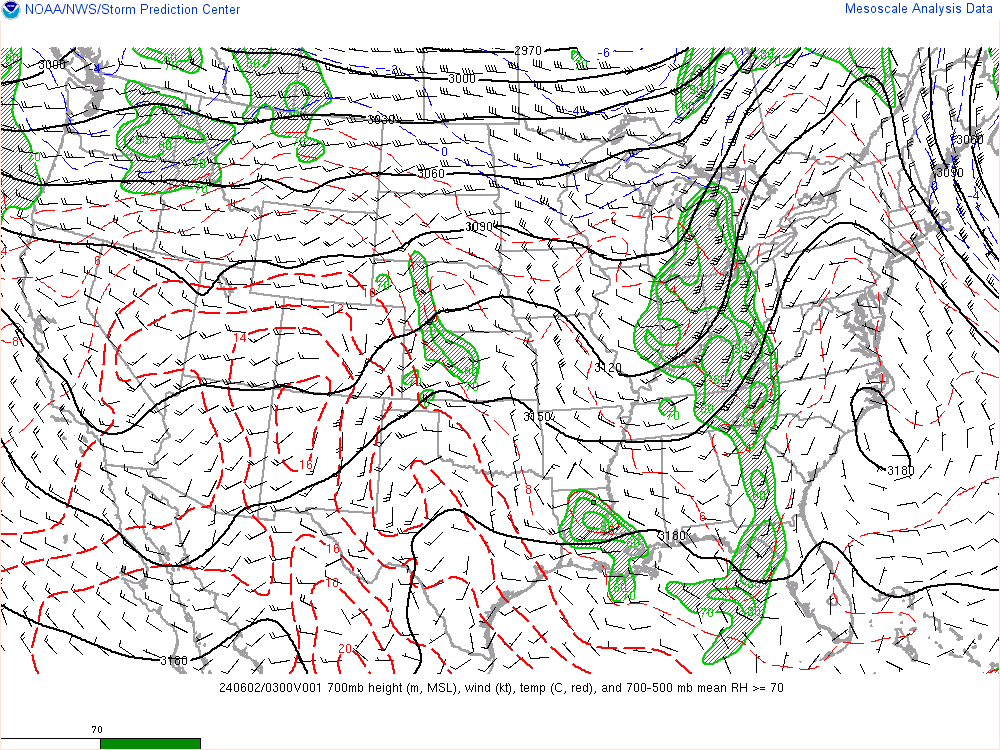 |
| 700 millibar temp and RH map |
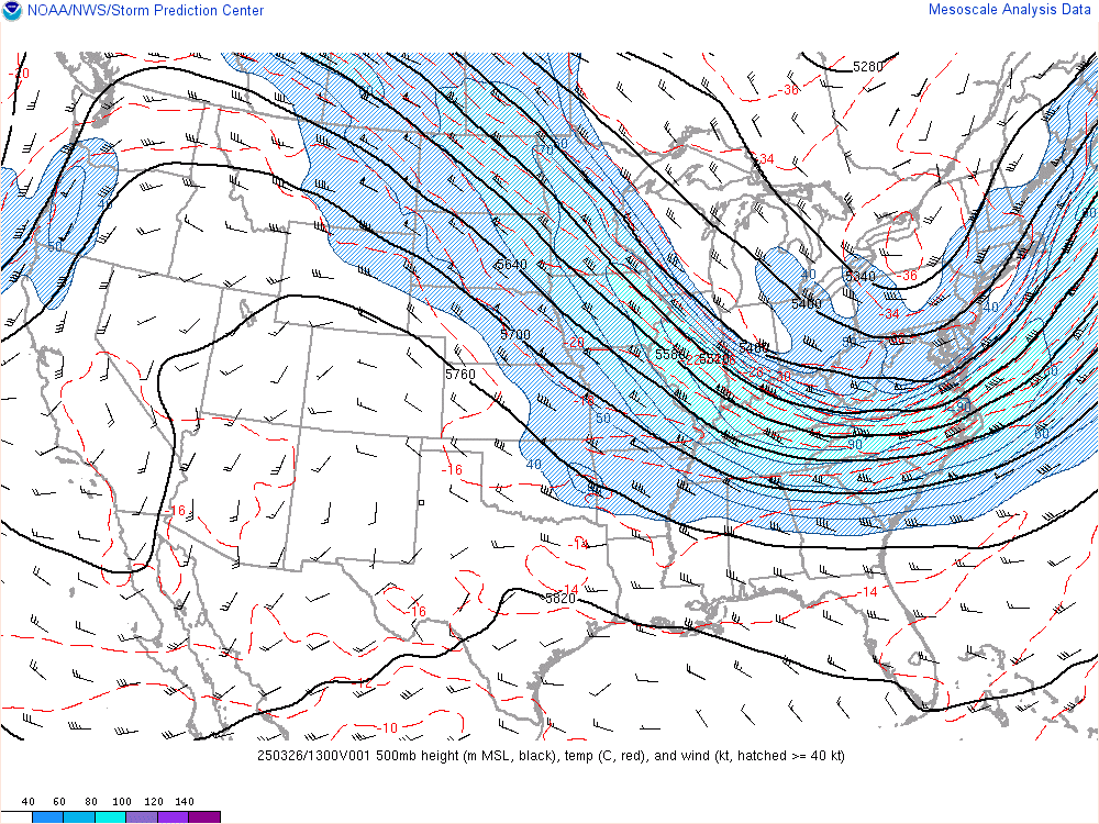 |
| 500 millibar wind speed map |
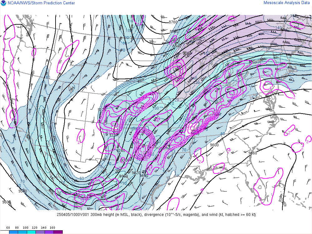 | |||||
| 300 millibar wind speed map |
The next map shows the 700 millibar layer of the atmosphere. On this map, isotherms are also indicated on the map, and so are height contours. As you can see only slight warm advection is occurring in the layer, which is also supporting the warming of the surface temperatures. The green fill on the map is indicating relative humidity. The lighter green fill indicates areas of 70% relative humidity. A general rule of thumb is that areas enclosed in 70% relative humidity on an upper air chart will most likely be cloudy. This does not always account for low level clouds. Areas of 90% humidity (darker green), usually indicating that some form of precipitation is falling in these areas. As you can see, this system has quite a bit of moisture associated with it. You can also see, the low pressure system on here. As you may have noticed, the low pressure is intensifying with height, indicating that the surface system will intensify.
On the next map, is the 500 millibar map. This map to the left is showing areas of constant wind speed (theoretically). This is the map that you would usually look at to determine the general trough/ridge pattern. The wind speed and direction in the 500 millibar layer usually indicate the speed and direction that a system will move at the surface. Generally, surface systems will move in the same direction, but at the half the speed of the winds of the 500 millibar layer. But don't be fooled, you will not be able to determine the correct movement of this system just by looking at this map, as the trough is expected to change, as told by the next map.
On the 300 millibar map, this is where the jet stream is located in the atmosphere. This is the layer of the atmosphere that you want to look at when determining where and how a surface system will move, and how the other layers of the atmosphere will change with time. The pink contour lines on the map, indicate areas of divergence in the upper atmosphere, which divergence in the upper atmosphere helps initiate surface low pressure and convergence, generating precipitation. As you can see above the storm system, are areas of divergence, which will also help a surface system to intensify. Another general rule of thumb is that when an area of higher wind speeds (a jet streak), will cause an intensification of the trough. As you can see, this what is likely to happen, while also intensifying the main storm.
So here is the forecast. It looks like this storm will continue to move northeastward, allowing the precipitation shield to expand over a large portion of the Midwest. Heavy snow will intensify over the plains and expand eastward, as an arctic air mass surges down from Canada. As it collides with the warm air from the Gulf of Mexico, heavy rain will expand, causing heavy downpours over a large area and cause flooding in areas west of here. Around here, the rain will not spread into the region until later this evening and later tonight. By early Sunday morning, a steady rainfall will be underway, with possibly heavy downpours at times, tapering to showers by the afternoon hours. With the shorter duration of this event, I expect precipitation amounts through Sunday Night to be in the quarter inch to an inch range, which will likely not cause flooding problems by itself, but will likely exacerbate pre-existing flooding problems. If the system is stronger than expected, and the system draws more moisture from the Gulf of Mexico, northward into Indiana and Ohio, rainfall may be heavier, but at this time it does not look like this will happen. Then, overnight Sunday, showers will become more numerous and widespread likely becoming steady rain by Monday morning. This second round looks to bring more precipitation, with possibility of different precipitation types. This second round will likely make flooding much worse over Northwest Ohio and Northern Indiana. There are some models that are hinting at a winter storm event over the area by Monday afternoon and night. These models are forecast arctic air to move into the area, changing the rain to snow by Monday afternoon. Some of these models are forecasting the snow to become heavy at times, especially north of U.S. highway 24. The NAM is even showing the possibility of some 12-18 inches of snow in parts of Northern Indiana, while areas north of U.S. Highway 24 will likely have more along the lines of 6-8 inches, if this model verifies. If we look at the ECMWF, this model is generally right in the middle of both the GFS (which is taking a southern route with this system, bringing the heaviest snow south of this area) and the NAM (which has the northerly route with this system, bringing the higher snow totals just to the north of here in Northern Indiana and Michigan.). If the ECMWF were to verify, it looks most of Northwest Ohio would be in for a very hefty snowstorm, with the possibility of over 12'' possible! Right now, I am very uneasy about a solution for heavy snowfall as it seems to early. Generally, the ECMWF is the best at winter weather forecasting, so we'll have to keep looking at the next several runs. I will update if anything changes in the forecast. If you want to see the analysis maps yourself, go to this link: SPC Mesocast.
Tuesday, November 29, 2011
Winter Storm Alert
Finally, after hours and hours of heavy rainfall and gusty winds, the heavy rain has switched to heavy snow over a large portion of Northwest Ohio and Northeast Indiana. With the earlier than anticipated changeover to heavy snow, I expect snow totals to be higher than originally expected. Instead of the 2-5 inches for extreme western Ohio, expect 4-8 inches with possibly higher amounts. One thing that could go wrong is that the snow would end early than anticipated, which would bring snowfall amounts to 3-6 inches. Farther east, near Defiance and Toledo, I expect 1-3 inches or possibly higher, with snowfall totals around an inch east of this line. The Winter Storm Warning is only for extreme western Ohio, for the counties of Paulding, Defiance, and Williams Counties. The winter storm warning is calling for accumulations of 4-8 inches or more in these areas, with the possibility of extremely heavy snow and thundersnow. Just a few minutes ago, there was thunder and lightning here in Antwerp. I have heard that thundersnow has been reported all over Northeast Indiana and Northwest Ohio, so expect more thundersnow through 7 or 8 tonight. Even though radar is showing the back edge of the snow moving westward through Northwest Ohio, I expect that as the storm system turns to the northeast, that the snow will increase in intensity and duration. The snow will gradually lighten during the early morning hours and taper off by sunrise. Scattered light snow showers should continue through the morning hours, with cloudy conditions prevailing for most of the day. Total snowfall accumulations will be 5-8 inches in Northeast Indiana, with 8-11 inches possible in Angola and Hillsdale, Michigan, while snowfall totals in Northwest Ohio will range from 4-8 inches in Paulding County to 8-11 inches in Williams County.
Tricky Forecast.
Right now, moderate to heavy rain is located over most of the area. This has caused rainfall amounts of one to two inches over most of Northwest Ohio. One thing that may be a problem is the fact that the dry slot is currently trying to edge into the area, although it is having a hard time of it. If it does end up moving into the area, expect rain to taper probably by 7 or 8 a.m. The rain will then move back into the area by 10 a.m., and intensify, and at the same time snow will begin to develop over Western Indiana. These snow bands will be developing a lot sooner than what was expected last night, as the cold air aloft and at the surface will make snow and convective snow bands favorable to form farther west. At the same time, heavy rain will persist and intensify after the dry slot moves out, while cold air nudges into the area, dropping temperatures from the upper 30's and lower 40's, to temperatures near freezing by mid-late afternoon. This will finally allow rain to transition to snow. Now the National Weather Service has issued a Winter Storm Watch for most of Northeast Indiana calling for 4-8 inches and possibly more. I see no reason why they don't issue a winter weather advisory for extreme western Ohio, as models indicate that we could get in on the heavy snow also. Actually, the NWS states in the forecast that Antwerp will probably have periods of heavy snow tonight, but only a 1- 2 inch accumulation, which is what is indicated by the NAM and the GFS. At this time, as most models have made an eastward shift in the storm, I think that the NAM and GFS have the snowbands to far west, as they have the cold air entering the region later than what most models do. My forecast calls for a solid 2-5 inches is possible over extreme western and northern Ohio, while areas east of a line from Defiance to Toledo will receive about an inch or less. Any towns in between will receive 1-3 inches of icy snow. Fort Wayne to Angola and Coldwater, will likely see snowfall amounts of 5-8 inches, especially if the heavier banding sets up. This snow will likely be wet and heavy when it falls and it will likely freeze to the roads after several hours of heavy snowfall. So for my forecast here it is. Today I expect the dry slot to move through bringing a temporary end to the heavy rain and flooding. By 10 a.m. or so, I think the rain will redevelop and reintensify, especially as the low strengthens. Winds will also increase from the north, with gusts over 35 mph. Temperatures will be falling slowly throughout the day, and temperatures will probably be near 35 by 2 p.m. Rainfall amounts between 1-2 inches possible. Rain will mix with snow by 2 p.m. and completely change over to snow by about 4 p.m. Rain will not change over to snow for areas east of Paulding until about 5 p.m. Tonight as the low intensifies, convective heavy snow bands will set up, with the potential for thundersnow, which will enhance snowfall accumulations, especially west of Fort Wayne where the potential for over 10 inches of snow remains a possibility. These heavy snow bands will move through extreme western Ohio, bringing snowfall rates of 1-2 inches an hour, for a couple of hours, which if the storm is farther east than anticipated, expect these to produce heavy snowfall accumulations. My forecast is calling for a solid 2-5 inches (this may change by this afternoon, as uncertainties exist) for extreme western Ohio, while in between Antwerp and Defiance, I expect 1-3 inches, and anywhere east of Defiance less than one inch. From Fort Wayne to Angola and Coldwater, I expect 4-8 inches possibly 10, and farther west over Columbia City and Warsaw, I even expect 6-10 inches. (Again, this forecast may need revised by this afternoon, as uncertainties still exist.) No matter how much snow we get, I believe the snow will last through 3 a.m. before tapering off, with leftover snow showers for Wednesday. If anything changes I will have an update by this afternoon. Stay tuned for further updates.
Monday, November 28, 2011
Crazy Forecast. Flooding to Heavy Snow.
Over the next two days, expect some of the craziest weather that has hit around here in a long time. Everything from flooding to heavy snow will be prevalent across the area. To begin, I want to start with tonight's forecast. Right now, current radar is showing bands of moderate to heavy rain beginning to move back into the region. Here is current radar: NEXRAD radar. According to the National Weather Service, light rain will overspread the region through the afternoon, bringing only light rainfall amounts for the time being. By 7 p.m., I expect heavier rain to overspread the region. Thermal profiles indicate that with the cold temperatures aloft and strong lifting could create pockets of snow tonight, but only accumulating to a dusting and more likely west of here. The rain will intensify later tonight, becoming heavy areawide and leading to flash flooding by morning in some areas, especially in areas that saw flooding from the storm last week and Sunday night's rainfall. Winds will also strengthen throughout the night, with gusts to 30 mph. Overall tonight, I expect rainfall totals near an inch in most areas. This is one of the reasons that the National Weather Service issued a flood watch. By Tuesday morning, rain will continue and possibly become heavier during the mid morning hours. Temperatures will not warm much during the daylight hours, probably dropping throughout the day. Starting temperatures will be in the lower 40's, and by afternoon, temperatures will probably drop into the mid 30's. According to some of the computer models, a dry slot may work its way into areas south of Fort Wayne and Van Wert. This could cause lower rainfall amounts than expected. I am very cautious about this, mainly because of how much moisture is being brought into this system. Even if there is a dry slot, I expect the rain to only lighten up or becoming showery for a few hours. By about 4 or 5 p.m., precipitation will reintensify, with rainfall becoming heavier across the area. By this time, flooding will be a serious concern, as 2 to possibly 3 inches of rain will have fallen. Here comes the tricky part in the forecast. Around this same time, some computer models are suggesting that snow will begin to mix in with the rain, especially just west of Fort Wayne. Depending on when the rain mixes with the snow, will determine how much snow falls Tuesday Night. At this time, the mixing will likely begin here in Antwerp around 5 p.m. By 7 p.m., the rain will completely change over to heavy wet snow, as a large band of heavy snow makes it way into the area. From past experience, during the type of snow events that happen at the end of heavy rain events, usually the Weather Service and computer models under forecast snowfall amounts. We'll see what happens, but I think that the snow may be heavier than what many forecasts are predicting. The snow will likely last through the nighttime hours, probably until about 3 a.m., becoming progressively lighter, with the heaviest snow falling at about 9-11 p.m. So here are my thoughts on precipitation amounts. As more data comes in I will update either this evening or tomorrow morning. For rainfall amounts, most of Northwest Ohio will likely see in the range of 2 to 3 inches with possibly higher amounts. This will cause flash flooding, flooding on roadways, and moderate flooding along the Maumee River basin. This greatly exasperate flooding problems right now. If the dry slot does move farther northward then expected, then expect rainfall amounts of around 2 inches. As for snowfall amounts, this will be trickier, mainly because early season snow events are harder to forecast with all of the warm air around. Right now I'm expecting snowfall amounts on the order of around an inch or less for areas east of Defiance. From a line from Antwerp to the Michigan state line, expect snowfall amounts of around 2-4 inches with possibly higher amounts in areas that experience heavier snow. This may need to be lowered or brought up especially since Antwerp is right along the line for heavier snowfall. If the storm shifts farther east, expect as much as 3-6 inches in Antwerp. If it shifts farther west, expect 1-2 inches in Antwerp. Along a line from Fort Wayne to Coldwater, Michigan, I expect the heaviest amounts with possibly 3-6 inches falling, and near 5-7 inches in Coldwater. This is also debatable, so expect changes in the forecast.
|
| The 12z GFS is forecasting 2-4 inches for Antwerp, while areas north and west of Fort Wayne will see 6-10 inches of snow. |
Sunday, November 27, 2011
My Thoughts on the Long-Range Forecast.
As quite a few meteorologists have, I have come to the conclusion that I need to make few corrections to my long range forecast. In my original final forecast made back at the end of October and early November, I stated that the second half of November would be very cold and somewhat dry around. As we all know this didn't happen. In fact, quite the opposite happened, with a somewhat warm and very wet pattern making it seem as if winter would never come. In this article, I will try to explain my revisions to the forecast as well as what went wrong.
For the final days of November (where we are now), I expect very cool temperatures after the last storm system comes through. On Wednesday, November 30, I expect temperatures only in the mid to upper 30's, under partly to mostly cloudy skies. These temperatures are only slightly below normal and not so bad for this time of year. During this time period, I expect that the teleconnections will finally become favorable for winter weather across the U.S., especially as we head into the first and second weeks of December. Currently, (as of Sunday, November 27) the Arctic Oscillation Index, a teleconnection that indicates the strength of the polar vortex, is still strongly positive. The Arctic Oscillation (AO), is a teleconnection (mode or phase of the atmosphere) that changes due to changes in temperatures in the lower stratosphere (layer of the atmosphere just above the troposphere). When these temperatures are above normal above the Arctic, surface temperatures warm, and create an atmospheric phenomena called the Greenland Block. The Greenland Block is a ridge of high pressure above the Greenland land mass that causes a metaphorical "road block" in the jet stream. Instead of the jet stream traveling west to east through the Atlantic, it takes a large northward swing into the Arctic. This sets up a major trough in the upper atmosphere over much of North America, sending very cold air southward during its NEGATIVE PHASE. Usually, when the AO is negative cold and wintry weather is prevalent over the United States during the winter months. During its positive phase, just the opposite is true. The positive phase causes a zonal or more west-east flow in the jet stream, allowing for warm air to penetrate farther north into the United States. Another index called the NAO, usually correlates strongly with the AO. When these two are both in their negative phase, and there is very cold air in Canada and Alaska, a major arctic outbreak is likely in the Lower 48 states. Over the last month or so, ever since that big Nor'easter hit the East Coast, both the AO and the NAO have been mainly positive, suggesting a warmer pattern for much of the United States. This is exactly what happened. Over the next several weeks, I expect both teleconnections to go negative, but it take longer than originally thought. It seems the computer models are all over the place with where these indices will go over the next few weeks. More than likely, I think that they will go negative especially by about December 15. After this I expect, the winter forecast of a cold and snowy winter to hold prominent. During the transitional phase from December 1 through December 14, I expect a few ups and downs in the pattern, with cooler than normal temperatures dominating throughout the period, while drier than normal conditions take hold in the beginning.
Another index that influences are weather quite a bit is the PNA. PNA stands for Pacific North American index. This teleconnection also has a positive and negative phase to it. In its negative phase, positive height anomalies (higher than normal pressure) exist over the Central Pacific, while a trough (lower than normal heights or pressure), exists in the Western United States and a large ridge is present in the Southeast. This, coupled with a positive AO/NAO will generally lead to very warm air spreading into the United States. In the positive phase of the PNA, negative height anomalies exist over the Central Pacific and above normal height anomalies exist over the Western United States, while the in the East, a trough dominates. When this is coupled with a negative AO/NAO, very cold air will likely dive deep into the United States, which explains the very cold weather during last winter. Over most of November, the PNA index ranged from neutral to strongly negative, leading to the development of a southeast ridge, allowing for warm and humid air to spread from the Gulf of Mexico into the East. Right now, computer models are in fairly good agreement on what this index will likely do. It looks like it will become positive, allowing for a trough to develop in the East. Because it is not coupled with a negative NAO/AO for the time being, only below normal temperatures will dominate for short periods of time, with some fluctuation in between. All in all, until all of the teleconnections are in agreement, I expect only slightly below normal temperatures to continue from December 1-14. After the fifteenth, I believe all of these teleconnections will align themselves in such a way that winter will finally hit hard, just like I said in the forecast.
For a brief summary of the long range forecast, to begin December, I expect temperatures to be slightly below normal, with highs in the mid to upper 30's. After this Friday, a clipper system will move through, bringing some colder air and temperatures farther below normal in possibly the low to mid 30's by next week. Next week, I expect temperatures to fluctuate a bit from below normal and some snow in the beginning of next week to temperatures near normal and some rain with any storm systems. After next week, the week of the 12th, I expect this to be the week of change, with temperatures starting the week possibly slightly above normal, with temperatures in the lower 40's, and ending the week well below normal, with highs even in the mid twenties. This will also be the time when I expect the storm systems to start coming back into the region as forecasts look like we will average below normal precipitation from December 1 through the 14, with an uptick in precipitation after the big cool down, likely in the form of snow. After the changeover, I expect the rest of December to also be cold and snowy, heavier than normal lake effect snows and a couple of moderate snowstorms. I would even hope for a snowstorm or blizzard during the week of Christmas! For the end of December, unlike last year, I expect to end cold and dry. By January, the same pattern may continue, but as of this time, I am really not sure if the pattern will reverberate back to what happened in November. This is the official forecast. If there are any updates I will revise my forecast again.
For the final days of November (where we are now), I expect very cool temperatures after the last storm system comes through. On Wednesday, November 30, I expect temperatures only in the mid to upper 30's, under partly to mostly cloudy skies. These temperatures are only slightly below normal and not so bad for this time of year. During this time period, I expect that the teleconnections will finally become favorable for winter weather across the U.S., especially as we head into the first and second weeks of December. Currently, (as of Sunday, November 27) the Arctic Oscillation Index, a teleconnection that indicates the strength of the polar vortex, is still strongly positive. The Arctic Oscillation (AO), is a teleconnection (mode or phase of the atmosphere) that changes due to changes in temperatures in the lower stratosphere (layer of the atmosphere just above the troposphere). When these temperatures are above normal above the Arctic, surface temperatures warm, and create an atmospheric phenomena called the Greenland Block. The Greenland Block is a ridge of high pressure above the Greenland land mass that causes a metaphorical "road block" in the jet stream. Instead of the jet stream traveling west to east through the Atlantic, it takes a large northward swing into the Arctic. This sets up a major trough in the upper atmosphere over much of North America, sending very cold air southward during its NEGATIVE PHASE. Usually, when the AO is negative cold and wintry weather is prevalent over the United States during the winter months. During its positive phase, just the opposite is true. The positive phase causes a zonal or more west-east flow in the jet stream, allowing for warm air to penetrate farther north into the United States. Another index called the NAO, usually correlates strongly with the AO. When these two are both in their negative phase, and there is very cold air in Canada and Alaska, a major arctic outbreak is likely in the Lower 48 states. Over the last month or so, ever since that big Nor'easter hit the East Coast, both the AO and the NAO have been mainly positive, suggesting a warmer pattern for much of the United States. This is exactly what happened. Over the next several weeks, I expect both teleconnections to go negative, but it take longer than originally thought. It seems the computer models are all over the place with where these indices will go over the next few weeks. More than likely, I think that they will go negative especially by about December 15. After this I expect, the winter forecast of a cold and snowy winter to hold prominent. During the transitional phase from December 1 through December 14, I expect a few ups and downs in the pattern, with cooler than normal temperatures dominating throughout the period, while drier than normal conditions take hold in the beginning.
Another index that influences are weather quite a bit is the PNA. PNA stands for Pacific North American index. This teleconnection also has a positive and negative phase to it. In its negative phase, positive height anomalies (higher than normal pressure) exist over the Central Pacific, while a trough (lower than normal heights or pressure), exists in the Western United States and a large ridge is present in the Southeast. This, coupled with a positive AO/NAO will generally lead to very warm air spreading into the United States. In the positive phase of the PNA, negative height anomalies exist over the Central Pacific and above normal height anomalies exist over the Western United States, while the in the East, a trough dominates. When this is coupled with a negative AO/NAO, very cold air will likely dive deep into the United States, which explains the very cold weather during last winter. Over most of November, the PNA index ranged from neutral to strongly negative, leading to the development of a southeast ridge, allowing for warm and humid air to spread from the Gulf of Mexico into the East. Right now, computer models are in fairly good agreement on what this index will likely do. It looks like it will become positive, allowing for a trough to develop in the East. Because it is not coupled with a negative NAO/AO for the time being, only below normal temperatures will dominate for short periods of time, with some fluctuation in between. All in all, until all of the teleconnections are in agreement, I expect only slightly below normal temperatures to continue from December 1-14. After the fifteenth, I believe all of these teleconnections will align themselves in such a way that winter will finally hit hard, just like I said in the forecast.
For a brief summary of the long range forecast, to begin December, I expect temperatures to be slightly below normal, with highs in the mid to upper 30's. After this Friday, a clipper system will move through, bringing some colder air and temperatures farther below normal in possibly the low to mid 30's by next week. Next week, I expect temperatures to fluctuate a bit from below normal and some snow in the beginning of next week to temperatures near normal and some rain with any storm systems. After next week, the week of the 12th, I expect this to be the week of change, with temperatures starting the week possibly slightly above normal, with temperatures in the lower 40's, and ending the week well below normal, with highs even in the mid twenties. This will also be the time when I expect the storm systems to start coming back into the region as forecasts look like we will average below normal precipitation from December 1 through the 14, with an uptick in precipitation after the big cool down, likely in the form of snow. After the changeover, I expect the rest of December to also be cold and snowy, heavier than normal lake effect snows and a couple of moderate snowstorms. I would even hope for a snowstorm or blizzard during the week of Christmas! For the end of December, unlike last year, I expect to end cold and dry. By January, the same pattern may continue, but as of this time, I am really not sure if the pattern will reverberate back to what happened in November. This is the official forecast. If there are any updates I will revise my forecast again.
Crazy storm this week. Be Prepared for Snow.
This week looks to be a crazy one, especially in the first couple of days. According to the latest computer model runs, rain should continue today as a large storm system moves northward into Canada.
So far, the rain has been light, but the National Weather Service has said that rain bands are likely to intensify throughout the morning hours, bringing pockets of heavier rain. Therefore, most areas today will pick up around a half inch. Temperatures already reached a high of 59 today, so I expect temperatures to continue dropping, dropping to below 40 by this afternoon, as a strong cold front makes its way through. By tonight only showers linger, when the storm system will redevelop over the southern United States. This next system will have plenty of moisture from the Gulf of Mexico to work with, so expect heavy rainfall totals with this next rain event. It looks like rain bands will begin spreading northward by Monday around noon, starting as light rain and gradually becoming heavier. The rain will gradually get heavier through the night as the storm system strengthens. The National Weather Service expects rainfall totals on Monday from three-quarters of an inch to over an inch, and I agree with them, mainly because of how much moisture is associated with this system. Tuesday, heavy rain still continues with dropping temperatures once again from the lower 40's, to possibly lower 30's by afternoon. As temperatures drop, and as strong lifting occurs in the atmosphere over Indiana, Ohio, and Michigan, I expect pockets of snow to develop during the day, so don't be surprised if all of the sudden it starts to snow very heavily during the afternoon Tuesday. This is where the tricky part comes in. During the night, computer model runs have trended to a significant snow event area wide, with the heaviest snow totals right along the Indiana border on northward into Michigan. While areas east of Defiance will probably not see much snow accumulation, towns right along the Indiana border in Northwest Ohio will likely see at least moderate accumulations (the exact words of the National Weather Service), with heavier snow accumulations possible more likely in Northern Indiana and in Michigan. Right now, computer models are all over the place with snow accumulations, with the JMA producing over a foot of snow to the area, while the GFS is forecasting 1-2 inches and the NAM is forecasting 3-5 inches at most. If enough dynamic cooling takes place, and the surface cold air mass is cold and deep enough for snow, I would expect around 2-3 inches at a MINIMUM, with the possibility of snowfall amounts approaching 5 or 6 inches especially farther north. This will be something interesting to watch. All in all, rainfall totals from Sunday afternoon through Tuesday Night, will reach over 4 inches, inducing river flooding and flooding in low lying areas. Depending on when the cold air arrives, expect travel issues as Tuesday Night's snow will heavy and wet in nature with several inches possible. After the entire storm system passes through, the coldest air of the season will finally arrive, dropping temperatures in the mid to upper 30's, with some days in the lower 40's. By Friday, a small clipper system will bring snow showers, and renewed cold air mass, with highs possibly in the lower 30's, and lows in the lower 20's. After this, the computer models have gone crazy, with some pushing all of the cold air back out of the region. Even if this does happen, all signs are pointing to the fact that the teleconnections will line up by at the latest the 15th, where winter will finally arrive. With this, I also expect that by Christmas, winter will be well underway, with bitterly cold air and hopefully a white ground.
So far, the rain has been light, but the National Weather Service has said that rain bands are likely to intensify throughout the morning hours, bringing pockets of heavier rain. Therefore, most areas today will pick up around a half inch. Temperatures already reached a high of 59 today, so I expect temperatures to continue dropping, dropping to below 40 by this afternoon, as a strong cold front makes its way through. By tonight only showers linger, when the storm system will redevelop over the southern United States. This next system will have plenty of moisture from the Gulf of Mexico to work with, so expect heavy rainfall totals with this next rain event. It looks like rain bands will begin spreading northward by Monday around noon, starting as light rain and gradually becoming heavier. The rain will gradually get heavier through the night as the storm system strengthens. The National Weather Service expects rainfall totals on Monday from three-quarters of an inch to over an inch, and I agree with them, mainly because of how much moisture is associated with this system. Tuesday, heavy rain still continues with dropping temperatures once again from the lower 40's, to possibly lower 30's by afternoon. As temperatures drop, and as strong lifting occurs in the atmosphere over Indiana, Ohio, and Michigan, I expect pockets of snow to develop during the day, so don't be surprised if all of the sudden it starts to snow very heavily during the afternoon Tuesday. This is where the tricky part comes in. During the night, computer model runs have trended to a significant snow event area wide, with the heaviest snow totals right along the Indiana border on northward into Michigan. While areas east of Defiance will probably not see much snow accumulation, towns right along the Indiana border in Northwest Ohio will likely see at least moderate accumulations (the exact words of the National Weather Service), with heavier snow accumulations possible more likely in Northern Indiana and in Michigan. Right now, computer models are all over the place with snow accumulations, with the JMA producing over a foot of snow to the area, while the GFS is forecasting 1-2 inches and the NAM is forecasting 3-5 inches at most. If enough dynamic cooling takes place, and the surface cold air mass is cold and deep enough for snow, I would expect around 2-3 inches at a MINIMUM, with the possibility of snowfall amounts approaching 5 or 6 inches especially farther north. This will be something interesting to watch. All in all, rainfall totals from Sunday afternoon through Tuesday Night, will reach over 4 inches, inducing river flooding and flooding in low lying areas. Depending on when the cold air arrives, expect travel issues as Tuesday Night's snow will heavy and wet in nature with several inches possible. After the entire storm system passes through, the coldest air of the season will finally arrive, dropping temperatures in the mid to upper 30's, with some days in the lower 40's. By Friday, a small clipper system will bring snow showers, and renewed cold air mass, with highs possibly in the lower 30's, and lows in the lower 20's. After this, the computer models have gone crazy, with some pushing all of the cold air back out of the region. Even if this does happen, all signs are pointing to the fact that the teleconnections will line up by at the latest the 15th, where winter will finally arrive. With this, I also expect that by Christmas, winter will be well underway, with bitterly cold air and hopefully a white ground.
 |
| HPC rainfall prediction for the next five days. |
Subscribe to:
Posts (Atom)