Saturday, January 21, 2012

Snow Event Summary and Forecast

After a very neat snowstorm yesterday and last night, I would like to give a summary of the storm system.  This system developed from a strong wave of North Pacific low pressure systems that have been pounding the West for days on end.  Here is an analysis image of the jet stream configuration on Wednesday, January 18, 2012.  As you can see in the analysis, an incredibly strong polar jet stream is making its way from the North Pacific to the United States, with the jet streak itself containing winds of almost 200 mph or 180 knots.  This jet streak is what produced the first clipper system that brought 1-2 inches of snow to the area (officially it brought 2 inches of snow to Fort Wayne.).  As the day progressed Wednesday, subtropical moisture from the subtropical jet stream was pouring into the Pacific Northwest, creating heavy snowfall, heavy icing and heavy rain, along with high winds and thunderstorms to some areas.  Seattle during this time frame had record amounts of snowfall.  Below is an image of the 700 millibar relative humidity values on Wednesday.  As you can see, there was plenty of moisture with the system in the Northwest.
By early Thursday morning, a shortwave, along with low level frontogenesis generated an area of light to moderate snow over Iowa, Illinois and Indiana, which eventually spread over the area by late morning.  That night, the clipper system that brought the snow, pushed a strong cold front through the area, causing temperatures to drop down to 2 degrees by the early morning hours of Friday.  Here is an analysis image of the 850 millibar level Friday morning.
Again, you can see that there was a strong baroclinic zone (note: a baroclinic zone is an area in which temperatures vary drastically, which can lead to the development to the develop of a major storm system if conditions are right.  Temperatures on this map are in degrees Celsius) which was draped across the Midwest.  This baroclinic zone lead to the development of this 850 millibar low, located over the lee side of the Rocky Mountains, causing an intensification of heavy snow over Iowa and Illinois, later spreading eastward into Indiana, Ohio, and Michigan by mid afternoon.  As you can see warm moist flow from the Gulf of Mexico over the very cold surface air was causing heavy snow to break out over the Great Lakes and Ohio Valley.  Frontogenesis is the intensification of a baroclinic zone, which causes strong upward motion and the intensification of bands of precipitation.  These two maps below show that strong frontogenesis was occuring over the main heavy snow area over Illinois, Iowa, and Wisconsin, with frontogenesis also occuring over the Ohio Valley as well.


This also caused the intensification of heavy snow bands, leading to widespread amounts of over 8 inches in Iowa and Illinois.  The storm headed eastward by late Friday afternoon, intensifiying at the same time, but also causing snow to change over to sleet and freezing rain in Southern Indiana.  After that, heavy bands of snow moved through Northeast Indiana and Northwest Ohio, causing near whiteout conditions at times.  By 8:00 p.m. last night, increased frontogenesis and uplift caused even heavier bands of snow to develop but they were developing near Indianapolis.  Surprisingly, even though radar indicated heavy snow south of here, our snowfall was coming down just as heavily, because they had larger flakes of wet heavy snow, rather than small, dry flakes of snow.  This still allowed the heaviest snowfall totals to fall from Fort Wayne to Paulding, with a general 4-7 inches falling in these areas.  Snow tapered off over the entire area by 3:00 a.m. last night, leaving many areas with over 6 inches on the ground.  Officially, in Antwerp, I have recorded an average of 6 inches, with some drifts deeper than that.  In Fort Wayne, official snow totals from yesterday was 3.8 inches (before midnight), with probably an additional inch or two falling after midnight.  This brings Fort Wayne's seasonal snowfall total to exactly 24 inches, which is 7 inches above normal for this time of year.  Surprisingly enough, you may have thought this winter was relatively snowless in the area, but we have actually had more snowfall than last year's snowfall total by this time, and we thought last year was really snowy!  The monthly snowfall for January 2012 is 12 inches which is 5 inches above normal.  With the long-range looking like it is right now, we may see at least one more snowstorm before the month of January ends. 
As for the forecast for the next three days, expect much below normal temperatures today, with highs in the low 20's and upper 10's.  By tonight, strong warm air advection will take place aloft, caused by another strong storm system moving out of the Rockies.  As warm air rides up and over the arctic air at the surface, expect an increase in clouds and possibly freezing drizzle tomorrow morning.  Warm air will then begin mixing down to the surface, causing temperatures to rise.  This warming will be strongly offset by cooling with the frigid ground, which will only allow the warm up to cause temperatures to climb into the mid and upper 30's.  By Sunday, significant cyclogenesis will occur with a strong cyclone in the plains states, causing an intensification of the low level jet stream, which will pump warm, moist air into the region.  On the nose of the LLJ (low level jet), widespread heavy rain and thunderstorms will develop late Sunday Night, with the possibility of a QLCS squall line moving through with strong winds and possibly a tornado (right now the threat for severe weather is low, but there is that little chance that conditions will come together just right to form a major severe weather event.).  Heavy rain, combined with rapid melting of the snow cover, will allow for the possibility of widespread flooding to take place across the area.  By later Monday afternoon, temperatures will drop drastically behind the cold front, but they will not be as cold as it was last week.  Continue to read my updates for further forecasts.


Thursday, January 19, 2012

Snowfall Update and Forecast.

After a very fluffy and snowy morning commute, many of you may be wondering what will happen with this next snow event.  The local TV weatherman may be passing this next event off as insignificant, but recent model forecasts and analysis indicate otherwise.  As I mentioned yesterday, if the ingredients come together just right, we may be in for a significant snowfall Friday afternoon into Saturday morning.  Right now, I'll start with what's going on.  A moderately sized Alberta Clipper is now moving from northern Michigan into Canada, which is what caused the snow earlier today.  As it moves away, the clouds should clear somewhat, as drier air makes its way into the area.  Areas south of U.S. 30 will continue to see light to moderate snow through the rest of the afternoon. Tonight, I am expecting clouds to continue clearing, giving way to clear skies by evening after lake effect diminishes.  This will allow temperatures to drop below 10 degrees tonight, some areas will drop to about 5 or 6 degrees, with even colder wind chills.  By the very early morning hours, cloud cover will increase ahead of the next storm system.  This system will be a quick, but strong, disturbance, originating out of the same storm train that brought Seattle a record-breaking snowstorm, and is still bringing a large part of the west heavy snow, heavy rain, heavy icing, and high winds.  This system will quickly move out of the Rockies and into the Midwest tomorrow morning, and with the limited moisture that it has, will cause moderate snow to break out over Nebraska and Iowa.  If the storm would not change its characteristics, we would probably see snowfall amounts on the order of 1-3 inches, instead of the amount I am forecasting.  When this relatively weak surface low (at the time) moves into the Midwest, it should begin picking up moisture from the Gulf of Mexico.  At the same very strong isentropic lifting will occur over our area, causing widespread snow to develop ahead of the system (note: an isentrope is a line of equal potential temperature, which is the temperature an air parcel will have if raised or lowered to the 1000 millibar level.  When air flows upward on these isentropes, it causes vertical motion and clouds and precipitation will form if it is fairly saturated.).  Other features, such as strong frontogenetical forcing at the surface, could possibly cause mesobanding of heavy snow, leading to the possibility of high snowfall rates (1-3 inches per hour snowfall) for several hours Friday night.  Forecast soundings that I have looked at have shown me that temperatures will remain below freezing throughout the entire atmosphere above us Friday night, leading me to forecast not much in the way of sleet and freezing rain.  But, the forecast NAM sounding for 11 p.m. Friday night is showing temperatures at the 850 millibar becoming very close to freezing point, which means there is the possibility that some areas, especially south Fort Wayne and Paulding, could see some sleet mix in. Other than that, most areas will see heavy snowfall Friday night.  By early Saturday morning, snow will end across the area, probably around 4 a.m.. Right now, the latest short range computer models are pointing to the heaviest area of snow remaining just to the west, near Chicago, but we could also be in this band of heaviest snowfall.  Right now, my forecast has the potential for 4-8 inches of snow to fall (which is close to the what the National Weather Service is predicting, 3-7 inches).  The 12z GFS has some isolated areas in Northwest Ohio and Northeast Indiana to receive over 8 inches of snow, depending on how much mesoscale banding of snow takes place.  If more sleet mixes in than expected, than those areas will probably see 2-5 inches of snow, especially south of a line from Paulding to Fort Wayne.  If more moisture is available, strong isentropic upglide, along with stronger frontogenetical forcing, I would definitely expect much higher snowfall totals.
   As for the warm up next week, it really won't be that big of a deal.  Temperatures will likely reach the upper 30's and lower 40's by Sunday and Monday, with another strong storm system returning.  This strong storm system could very heavy rain, and a severe weather potential to our area, with the possibility of a QLCS squall line forming and racing through the area.  This combined with rapid snowmelt and rainfall over an inch could cause some flooding to occur in many areas.  This is the potential we have to watch out for next week.

Wednesday, January 18, 2012

Snowfall Potential Next Three Days

Some exciting news yet again.  For all you snow lovers out there, another snow event is on the way, and if conditions all come together correctly, then expect some significant snow amounts.  This discussion will be very brief for the time being, but I will give a few details.  First off, two storm systems will be moving that will both bring the potential for accumulating snowfall.  Second of all, these storm systems are originating from a very strong train of storms coming into the Pacific Northwest on the nose of a very powerful jet stream with winds of over 190 knots (219 mph!).  This combined with cold surface air will create the potential for snowfall tomorrow morning and once again on Friday.  Here's what I am expecting at this time.  Tomorrow's snowfall will likely be in the range of 1-2 inches at most, mainly because this next storm isn't very strong and is doesn't have a whole lot of moisture to work with.  For Friday's system, I am expecting much more significant snowfall amounts, with possibility of more than several inches to accumulate.

Monday, January 16, 2012

Pattern change update!

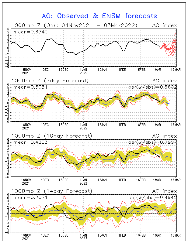
Many meteorologists have already given up on the fact of a pattern change, especially as most long-range ensemble forecasts offered little hope this week for sustained cold in the U.S. through the 25th of January.  But an interesting piece has come up, that may be our last hope for a major reversal into a winter like last year.  According to the latest Climate Prediction Center ensembles, the Arctic Oscillation is expected to take a major nosedive to near record low values (-4 to -5).  This would cause a second major weakening of the polar vortex, allowing brutal arctic to drain out of the arctic.  This major nosedive is expected to happen now, and in the next several days, and really bottom out by the 25th of January.  Right now, this could be our last major hope for a recovery of below normal temperatures for long periods of time and snowy conditions.  The sad thing is is that most of the long range operational models are not showing any kind of long term cold in the next two weeks.  But if the arctic oscillation were to go as strongly negative as it is expected to, than expect some major cold (and of course snow) in about a week or so.  Before that happens, operational models are expecting a major warm up into the lower and middle 50's by Sunday of next week, before a potentially a very strong arctic cold front, along with a strong low pressure system pulls extremely cold air out of the depths of Alaska, which is currently where the coldest air in the Northern Hemisphere.  This is good news, because if Alaska had not been cold this winter, we wouldn't have had any type of snow or snow event so far this winter, and since the cold air in Alaska will keep building right through February, expect more sustained arctic outbreaks and snow events.

Wednesday, January 11, 2012

Snowfall on the Way. Much colder and stormier pattern.

For all you snow lovers out there, this may be your chance for a significant snowfall event that will not be destroyed by rain or any other factors.  In fact, snowfall totals may be the highest of the entire season in some parts of the area.  Right now, for the rest of today through early Thursday morning, expect off and on light rain to continue.  I am NOT expecting much in the way of rainfall as most of the moisture will be confined to east of the area.  What's happening is that a very strong upper level closed way is moving through the southeast.  This is what is causing a rather deep storm system to form at the surface, with a central pressure of 996 millibars.  On the other hand, a rather strong and robust upper level system in the northern stream is intensifying and moving quickly southward out of Canada.  As this system attempts to phase with the southern stream system, rapid cyclogenesis of yet another surface low pressure system will commence just to the north of us.  At the same time, it will draw in extremely cold arctic air, with much below average temperatures.  As its associated arctic front races through the area tomorrow morning, expect a quick transition from rain to light snow in about an hour's time.  This snow will taper off for a few hours before the second system brings in bands of moderate to heavy snow.  Even though this system does not have an ideal amount of moisture associated with it, high snow to water ratios, intense lifting, and lake enhancement, will create an environment capable of producing moderate to heavy snowfall amounts and high winds.  By Thursday evening, temperatures will drop into the 20's as snow begins once again, at the same winds will increase quite a bit, with winds of 30-35 mph, creating near blizzard conditions especially west of Fort Wayne.  These bands of snow will continue to move through the area Thursday night into Friday, with about 2-5 inches on Thursday night (according to the GFS and NAM guidance) and another 1-3 inches on Friday, mainly Fort Wayne and west.  Overall, the National Weather Service is expecting 3-6 inches south of Route 6 to just south of Fort Wayne, with possibly 6-12 inches north of this line and west of Angola (due to lake effect), with parts of extreme northern Ohio picking up between 4-7 inches (this may seem a little high, and I really am skeptical of this amount of snowfall).  After the main snowfall event ends area wide Friday afternoon, lake effect snow will continue in many areas especially west of the Indiana state line, even though it is likely that some of the snow showers will make it into Northwest Ohio, bringing additional snowfall totals.  I will try to have another update by tomorrow night.

Saturday, January 7, 2012

Long-Range Update

Now for the Long-range update that I have been promising.  First let me explain what's happening.  Right now, in the Central Pacific, a raging La Nina is underway, with the Nino 3.4 region experiencing values near -1.1 degrees Celsius (note: these values are anomalies and not represent actual temperatures.  Actual temperatures in this region are near 70 degrees Fahrenheit.).  Over the last few weeks, this area of below normal sea surface temperatures has spread westward, causing a basin-wide La Nina.  This is what we had last winter, which means we should start seeing the weather pattern become closer to what happened last year, especially by the end of January.  One thing that has surprised many meteorologists is the fact that the SOI values have really dropped, even though the La Nina has in fact strengthened.  As explained in previous posts, SOI stands for Southern Oscillation Index.  When the index is positive, a La Nina is underway, because the pressure difference between Tahiti and Darwin, Australia is positive.  When the index is negative, an El Nino is indicated.  The daily values for yesterday and the day before have been sharply negative, which is not a good sign for the rest of the winter.  If these negative values continue for a lot longer time, expect the La Nina to weaken significantly, and in fact reverse to an El Nino by the middle of March or April.  This would cause a lot less precipitation over the area, which is really bad news for snow lovers in the Ohio Valley.  Right now, this scenario does not look at all likely, mainly because these negative values may be because of the westward expansion of colder than normal waters in the equatorial Pacific.  In fact the most likely scenario right now is that the La Nina may be actually strengthen a bit before the end of January, before beginning a gradual weakening trend.  The CFS climate model is forecasting the continued strengthening of a moderate La Nina to a strong La Nina, with the La Nina becoming stronger after July.  This would mean, a very snowy end to winter, even if temperatures are above normal (not taking into account the pattern change).  On the other hand, the CFSv2 model (an enhanced version of the CFS model) is forecasting the La Nina to remain steady or slightly strengthen before the end of January, and then it it is forecasting a rapid weakening of the La Nina, becoming neutral by May and becoming an El Nino by July or August.  The most likely forecast is a combination of these models' forecasts, with a moderate strengthening of the La Nina through February or March, with a rapid weakening beginning in March, becoming neutral by July and possibly becoming El Nino by the beginning of next fall.  This will cause continued above normal precipitation and snowfall.  Another factor that I am taking into account is the teleconnections, which affect the position of the jet stream.  The NAO, which stands for North Atlantic Oscillation, is an index measuring the difference between observed sea level pressure between the Azores and Iceland.  When it is positive, a strong low pressure center is positioned over Iceland, when it is negative, high pressure is located over Iceland.  The positive phase tends to bring warmer than normal conditions to North America and Europe, while the negative phase tends to bring widespread cold and snowy conditions to North America and Europe.  Right now, ensemble forecasts have the NAO becoming negative especially after January 16th.  This will finally allow winter to return to the United States.  The next teleconnection, which is very closely related to the NAO, is the Arctic Oscillation or AO.  When it is in a positive phase, stratospheric temperatures become very cold over the Arctic, while in the negative phase stratospheric temperatures become much above normal.  When it is in its negative phase, cold, Arctic air is pushed southward out of the Arctic, causing brutal winters over the United States and Europe.  When it is positive, warm air dominates both continents, as a strong low pressure system dominates the Arctic, keeping the arctic air "locked up".  Ensemble forecasts show general agreement that the AO will go strongly negative by about January 16th, with the lowest values since December 2010 showing up.  This will finally allow winter to return to the United States, with several snowstorms possibly in our area after the mid month.  In fact, we could see some hefty snowstorms by February.  But for now, expect to be in a transition phase, with a more turbulent pattern before this happens.  One sign that shows this might actually be happening is the fact that a Significant Stratospheric Warming event is occuring, which is the tell tale sign of the weakening of the Polar Vortex, a major factor that has kept cold air out of the area throughout most of the winter.  In the lower stratosphere, over the past few weeks, temperatures have warmed from much below normal back in mid December, to well above normal in only a few day's time.  When significant warming in the stratosphere occurs above the Arctic, a disruption of the powerful polar vortex occurs.  The polar vortex is just the meteorological term for the very center of the brutal arctic air.  If this vortex weakens, that means that the cold, arctic can finally come rushing out of Canada, and stay in the United States.  Even though significant warming has occurred, the atmosphere usually takes a couple of weeks to respond to this burst of warm air.  Therefore, we should be seeing the longer outbreaks of Arctic air into the air by the middle or end of January, and continuing shots of arctic air into February and early March.  This will be something I will continue to monitor, so that an accurate forecast of arctic outbreaks can be made.  As an example, next week, a powerful cold front (just about as powerful as last Sunday's) will push through the area, dropping temperatures from the lower 50's to the lower and mid 20's by Friday of this week, with heavy lake effect snow returning.  This cold air will likely retreat after a several days, but there will not be as much warming as with the last time.  In fact, the Climate Prediction Center is forecasting that a large trough will dominate the country for the rest of the month, leading to frequent arctic outbreaks and rather stormy weather to persist across the Ohio Valley.  This may bring our first real snowstorms by the end of January.

Friday, January 6, 2012

Update Later Tonight or Tomorrow

Sometime tonight or tomorrow, I will have an update on the current situation and how this will affect the weather pattern in the next couple of weeks.  For a little sneak peak, it looks like the pattern may start to turn cold and snowy, especially by the end of January and into early February.  Next week a rather potent cold front will move through, causing a temperature drop back into the twenties with lake effect making another appearance.

Monday, January 2, 2012

Lake effect snowfall forecast.

After a cold front moved through Sunday morning, temperatures rapidly dropped from the mid 40's to the upper 20's by nightfall.  This caused many road and concrete surfaces to freeze over last night, allowing for accumulating snowfall.  I know snowfall has been highly variable throughout the night, with some areas in Northwest Ohio picking up over an inch of snowfall.  Instead of a few main bands of lake effect snow, there has been many bands of moderate to heavy snow, with some of them reaching as far south as Lima, OH.  This is because there is still strong directional shear, which will tear apart large bands of extremely heavy lake effect snow and break them into many bands of moderate or heavy snow.  Some of the main ingredients for extremely heavy lake effect snow have been in place for this event.  One of these ingredients is an extreme lapse rate, from the surface lake waters to the 700 millibar layer of more than 30 degrees Celsius.  This means that surface temperatures over the lake could be near 40 degrees, while temperatures at the 700 millibar layer are below zero.  This creates an extreme lapse rate and absolute instability, allowing for free convection to take place, even without a lifting mechanism.  There is also enough synoptic moisture to allow for heavy snow to form, once the instability causes air to rise and cool and condense to form snow squalls.  Another ingredient that is present, is high inversion heights.  Normally, in an arctic air mass such as this one, an inversion will usually exist about a 1000 feet above the surface.  With this situation, the instability has caused inversion heights to be raised to about the 400 millibar layer, which is over 20,000 feet in the atmosphere.  This allows for deep bands of heavy snow to develop.  The last major factor in the development of extreme lake effect snow is strong wind speed shear between different levels in the atmosphere.  If strong upper level winds line up with much weaker surface winds, long bands of snow will stream off the Great Lakes.  If the atmosphere exhibits strong veering or backing of winds with height, these bands of heavy snow will be sheared apart, causing a more widespread snow event, but with less snowfall totals.  This is what happened last night, but it is forecasted that later today, several heavy bands of lake effect bands will develop, stretching as far south and east as Northwest Ohio.  One feature that will enhance the lake effect is an upper level shortwave that will begin moving over the area by early afternoon.  This will cause numerous moderate to heavy snow showers away from the lakes.  According to the latest hi-res guidance, snowfall amounts will largely remain in the range of 1-3 inches in most of Northwest Ohio, with heavier snowfall amounts west of the state line.  Snowfall amounts will likely be as high as 15 inches near South Bend to Benton Harbor, Michigan.  Even though ingredients are near perfect for an extreme lake effect event around here, the best conditions will reside near Lake Ontario, where over three feet of snow could fall.  By tomorrow, snow will end over most areas except near the lakes, with very cold conditions still in place, with highs barely reaching the twenties.  After that a major warming trend will commence, bringing our area out of the deep freeze, and temperatures well above normal by the end of the week.

Thursday, December 29, 2011

Medium range update

Today, I just want to have a quick update with the weather.  Today through Tomorrow, I'm expecting scattered rain or snow showers.  Today's highs will be in the lower 40's.  It's really uncertain what will happen tomorrow, as the GEM and GFS are both predicting snow, with some rain mixing in.  Current indications are that models may be too cold with this system, which would mean an all rain event for the area tomorrow.  Precipitation amounts will be in the range of 0.25 to 0.6 inches tomorrow, along with some gusty winds.  By this weekend, Saturday and Sunday, a major storm system will form in Canada, bringing very strong winds to the area.  The one thing about this system that's different from many other storm systems over the last several months is that it will not bring much precipitation to the area, if the GFS forecast were to hold to true.  Instead of just a slight cool down after the storm moves through, a rather robust and strong arctic front will sweep southward out of Canada, dropping temperatures from the lower 40's early Sunday morning, to the lower and mid 20's by nightfall, along with some snow.  Temperatures will continue dropping throughout the night, possibly into the mid or upper teens, causing dangerous wind chills.  After the arctic front moves through, temperatures will remain very cold for several days before moderation begins once again.  By Monday, a major lake effect is expected to be underway, the first lake effect event of the season.  This could bring several snow bands as far south as Northwest Ohio and Indiana, possibly causing some travel disruptions.  This arctic front may be a sign of things to come, as long-range guidance indicates that by mid-January, a major and possibly record-breaking arctic outbreak may invade the United States, bringing temperatures that will be well below normal.  This arctic outbreak in mid January may be the pattern change that we have been waiting for.  Some models are even indicating that this arctic outbreak next week will be the pattern breaker.

Tuesday, December 27, 2011

Updated Snowfall Forecast

In many areas now, it is snowing and snowing heavily, especially closer to the Indiana/Ohio line.  As 850 millibar temperatures become colder, especially east of Fort Wayne, the snow flakes will become smaller, intensifying snowfall rates for a very short period of time.  The frontogenetical forcing has weakened, causing the main band of heavy snow to shift closer to Northwest Ohio and eastern Indiana.  With the latest radar trends, I expect the snowfall to end from west to east by 4 in Fort Wayne, 5 or 6 in Antwerp, and in Defiance in the early evening hours.  Even these estimates may be too slow as the main axis of heavy snowfall has significantly weakened and the whole band of snow is deteriorating.  Snowfall totals from Fort Wayne have been near 3 inches, while in Antwerp about 2-3 inches and east of Antwerp, one to two inches.  This snow will continue through late afternoon, accumulating 2-4 inches over most areas, with some heavier snowfall amounts especially north and east of Fort Wayne.  I expect some lingering back-end snow showers and some lake effect snow showers.  Accumulations tonight will be near a half inch to an inch.  Lows tonight will be very cold compared to the last several nights as they will fall into the lower 20's, causing significant icing.  Temperatures will be on the upward trend the rest of the week, excluding Wednesday when temperatures will barely make it into the lower 30's.  By Thursday, another clipper system will be side-swiping the area, with rain and snow showers.  By early next week, the next major storm system will be affecting the area, with above normal temperatures, rain, wind, and possibly snow.  Stay tuned for further updates.

Snowfall Update

Looking at the latest short range models, snowfall will likely continue later than what I was thinking on Sunday.  These models are showing that snow will not end over most of the area until late this afternoon mainly east of Fort Wayne.  This is good news for snow lovers, because a longer snowfall event could cause heavier snowfall accumulations.  My forecast of 2-4 inches will still hold for most of the area, with these amounts mainly in Northeast Indiana and Northwest Ohio.  Another thing that has shown up as a possibility that short-range models are not picking up on is mesoscale banding of the snow.  When this happens, heavier snowfall rates will fall causing heavier snowfall totals.  The National Weather Service is concerned that as the main band of snowfall (currently west of here) shifts eastward, strong upper level dynamic forcing combined with frontogenetical lifting along the surface cold front will cause temperatures to fall into the lower 30's for most of the day allowing for snow to stick easily on roads and grassy surfaces.  This intense lifting will cause a very heavy band of snow to form over parts of the area.  Right now the National Weather Service is saying that the threat area stretches from Huntington through Fort Wayne and right along U.S. 24 through Antwerp and right up to Toledo.  If this heavy band of snow would set up, many areas could see up to 4-6 inches of snow.  This seems a little high but it is a possibility.  This band will likely set up around 1 or 2 p.m. and continue for a couple of hours before tapering off in the early evening east of the Indiana/Ohio line.  Tonight, with fresh snowfall, temperatures will fall into the lower 20's and possibly upper teens.  By tomorrow, a fresh polar air mass will be in place across the area, which will cause temperatures to barely make it into the the 30's, with some areas in the upper 20's.  Later this week, another warm up into the 40's will occur, after a clipper brings some light snow to the area.  By New Year's Day, a major trough will set up in the Central Plains, causing a major storm system to form by Sunday and Monday.  At this time, this will likely impact the area with heavy rainfall, but with rapidly falling temperatures with the passage of the storm.  I will keep you updated on this storm threat next week.

Sunday, December 25, 2011

Merry Christmas! One last Forecast Update

Merry Christmas to everybody who reads this blog, thank you for coming to listen and read my forecasts everyday.  I hope everyone has a great Christmas even without the snow on the ground.  As for last minute updates to next week's winter storm potential, it looks like the heaviest snow totals will be along and south of U.S. 24.  At this time I would expect at least 2-4 inches of snow, and possibly a lot heavier amounts if the upper level moisture tongue can reach into our area, enhancing the heavy snowfall.  Some of the latest models have trended the storm southward, but this may not end up happening as the NAO is still positive and the AO is negative, causing the southeast ridge to push westward.  At this time, precipitation will start out as mixed Monday night, then quickly change over to all snow after 2 a.m. and snow will persist throughout most of the day Tuesday before tapering off late Tuesday afternoon and evening.  As I said before, snowfall totals will primarily be dependent on how cold it is and the track of the storm.  The snow will begin at an ideal time for snow accumulations, at night, so it will accumulate faster.  Second of all, temperatures Monday night, will be in the mid to upper 20's, allowing for freezing rain, sleet, and snow to mix in and then changing to all snow.  The trickiest part of the forecast will be the track of the storm.  If the track of the storm is further south, I expect snowfall totals to be light, and accumulate to about an inch, or we may end up getting nothing.  If the storm track is farther north, then I expect heavier precipitation totals, along with heavier snowfall accumulations possibly in the range of 4-7 inches or more (this last point depends on if the storm phases with the jet stream faster, and becomes stronger, because if this happens, the storm will track farther northward.)  This will be my last update until probably tomorrow afternoon, just before the storm hits.  Have a safe and Merry Christmas, praising the Lord and his birth!

Saturday, December 24, 2011

Winter Storm Possibilities

Great news for snow lovers.  The latest GFS and NAM have been showing a major snowstorm over most of our area with heaviest snow totals remaining along and north of U.S. Highway 30.  The catch is that temperatures will be only marginal as of right now for heavy snowfall accumulations.  Models such as the NAM are forecasting temperatures around here to be in the mid 30's, while some models such as the ECMWF are forecasting much colder temperatures during the snowstorm (if there is a storm).  Prospects for a snowstorm have only shown up in many model runs just recently and have been rather consistent with the NAM and GFS models.  Right now, both the GFS and NAM are the farthest north of the computer models, causing them to bring in more of a mix of ice and snow before changing to all snow.  If temperatures are as warm as what the NAM and GFS are saying, then expect a wet heavy snow to fall from the sky.  At the other end of the spectrum, the ECMWF has an all snow event with much colder temperatures allowing for a fluffier snow.  Since all three of these are very similar with this storm, a consensus of the models would bring this area a mostly snow event next week, with some sleet or freezing rain/rain mixed in.  While the exact timing of the storm is still in question, my current thinking is that snow will begin Monday night, then continuing through Tuesday night, with some sleet and rain or freezing rain mixed in throughout the day, with lows Monday night in the upper 20's and lower 30's, and highs on Tuesday in the lower to mid 30's, and falling throughout the day.  The GFS is not really consistent with its snowfall totals between its runs, but the latest run is showing rather exciting snowfall amounts (or what I would consider exciting) with most areas seeing 2-4 inches of snow, and some areas possibly more.  As for the NAM, well it doesn't go out that far to be predicting snowfall totals for this event, but it is predicting snowfall amounts of 1-3 inches Monday night, with more on the way for Tuesday.  This could be a pretty significant event so stay tuned for further updates.
As for the Christmas Day forecast, well, expect highs in the mid to upper 30's (pretty warm for this time of year) under partly sunny skies as well.  Won't be the best christmas because of the no snow cover, but it will still be fun.  Have a Merry Christmas everyone!

This map of the ECMWF 00z run is showing a snow event for the area.  Green colors indicate high relative humidity in the upper atmosphere, showing us where precipitation is likely to fall and the map with the low pressure centers on it shows us the position of storm systems and the position of the rain/snow line.  That rain/snow is the 540 line on the map, and on this forecast, the rain/snow line is well south of the area, indicating that most of the area will see snow.


Wednesday, December 21, 2011

Forecast Update through Tomorrow

A couple of things I forgot to mention I will talk about in this post.  One thing is that a large portion of the atmosphere will be saturated tonight and tomorrow over most of the area.  This is because of continuing showers and drizzle throughout the night.  This will cause nearly widespread fog to form tomorrow morning, becoming dense in certain areas, especially in the open areas.  Dense fog will likely continue through the mid morning and late morning hours.  Another thing, in an earlier post, I stated that rain showers could end as a period of snow Thursday night.  This is looking less and less likely.  Right now, it looks like just a few flurries Thursday night, with LES (Lake Effect Snow) possible on Friday and Saturday.  This is the last update until tomorrow morning.  Have a good night.

White Christmas Forecast, and Continued Long-Range Update.

Unfortunately, I have bad news once again.  Chances are becoming slimmer for a white christmas.  I am very sorry to say this, as we close out December, most if not all meteorologists long-range forecasts were wrong for the month of December.  Currently, most of the United States will close the month out well above normal.  Initial forecasts way back in October were saying that because it would so cold in the Midwest this December, they were expecting below normal precipitation, but above normal snowfall.  As you can see, we had just the opposite.  Instead of cold temperatures and well below normal precipitation, like last December, temperatures will close out December three to five degrees above average for the month.  This overall warmth, has lead to a very low snowpack across the country.  In fact, it may be the lowest snowpack the United States has seen in December since 2006, with only 25.6% of the country covered with measurable snow.  Another opposite that was seen in December, was above normal precipitation.  So far this December, we have seen nearly 3 inches of precipitation, not near as much as November, but still far above normal.  Currently, we are about 1.5 inches above normal for December.  The above normal precipitation throughout the year, has lead to some pretty impressive anomalies (departure from normal).  Right now, 2011 is the third wettest year on record at Fort Wayne, with nearly fifty inches of rain (or snow) fallen.  For comparison, this is the normal amount that places such as Central Florida receive in one year, and we have had more rain than many places in Florida this year.  The exact total for this year is 48.73 inches, which is well above what last year's precipitation total was, which was 32.46 inches.  If long-range models and forecasts are correct, I expect well above normal precipitation to continue through at least the first seven months of next year also.
Now for the white christmas forecast, as the current storm system moves out, not much of a cool down will take place, with another storm system tomorrow, causing temperatures to remain in the upper 30's and lower 40's.  Actually, temperatures on Thursday will remain steady throughout the day, then dropping in the afternoon, into the lower 30's by nightfall.  With the next storm system, we could end with a period of snow Thursday night, as temperatures will be in the upper 20's, and the 540 line (5400 meter thickness between the 1000 millibar layer and the 500 millibar layer, usually indicating the rain/snow line) will be well south of the area, leading to a period of accumulating snow, especially east of Fort Wayne.  On Friday, temperatures will drop into the mid 30's under mostly to partly cloudy skies, as the next storm system from the Gulf of Mexico moves northeast into the East.  The problem is that, this storm was originally forecast to bring us some light snow on Saturday, which does not look likely anymore, as the storm will be too far to the east.  Temperatures also do not look as cold as it originally did.  By Christmas Day, a few snow showers will be scattered throughout the area bringing surprise white Christmas's to a few areas.  Highs that day will be in the lower 30's and possibly colder, even though the National Weather Service is forecasting temperatures in the mid to upper 30's, I do think that this arctic air mass will be cold, and even cold enough to produce lake-effect snow.  By next week, yet another warming trend, but not as much as the last warming trend (into the lower 40's and upper 30's), with some periodic arctic air masses moving into the area through New Year's Day.  By New Year's Day, a new set of storm systems will be affecting starting once again the pattern of heavy precipitation, and once again this is where the long-range gets tricky.
   Yesterday, I mentioned some of the tid bits in the long range.  I did never get to mention the ENSO, so here goes.  According to the latest climate forecast models, the La Nina will continue to strengthen, possibly becoming a strong La Nina around -1.7.  According to the CFS, CFSv2, and the GFDL, they expect the La Nina to peak in strength around March, even though their respective forecasts vary in intensity.  The CFS is forecasting a peak around -1.9, the CFSv2 around -1.4, and the GFDL around -1.8.  If you average these values, you get -1.7.  As for precipitation and temperature extremes, the models are all varying from each other, so it probably isn't that wise to treat these forecasts as truth.  The CFS is forecasting a rather warm January, for the area, while in February and March, temperatures drop well below normal, leading to a very snowy end to winter.  The CFSv2, is forecasting above normal temperatures through June, with only slightly below normal temperatures for February.  As for precipitation, almost all of the models agree that precipitation will be well above normal for the next five months, leading to continued flooding problems, and possibly severe weather problems in April and May.  With the strengthening of the La Nina, I expect that this forecast will hold true.  But as for the next month, I have looked at the teleconnections and this is my good news (for snow lovers that is).  The NAO is expected to gradually drop into negative territory, allowing all that extensive cold in Canada to drop southward finally.  At the same time, even though there is less agreement among models on what the AO will do, there is a general downward trend in its values also, becoming negative by about January 1st, and continuing its downward turn.  The PNA, at the same time, will become positive, which is conducive to a west coast ridge, and east coast trough.  All of these factors, if these forecasts are correct, will converge right around January 1st, possibly making January a very cold and snowy month around here.  All of these factors, combined with the La Nina, will cause a very interesting middle and end to winter.  Not only will these factors converge, but also, solar output will also be taking a dip, leading to colder temperatures and therefore snowier days, instead of rain.  All of this could have serious consequences in the spring, because I am expecting major flooding this spring, even more so than last year.  This is my update, for more updates, tomorrow I will try to have an update.

Tuesday, December 20, 2011

Long Range Update and White Christmas possibility.

This morning, many of you probably woke up surprised to see it snowing.  Last night, I said that thermal profiles could be marginal for a sleet/snow/freezing rain event.  Well, I was right, sort of.  It turns out, thermal profiles were cool enough to support all snow in quite a few areas south of U.S. 6.  In Antwerp, the precipitation was all snow until it changed to rain around the noon hours, accumulating over an inch.  As you can see, this snow did not stick very well, as most of it has melted in this afternoon's light rain/drizzle, even with temperatures near 34.  As for the forecast through Thursday, expect rain showers becoming more numerous tonight, as a low pressure system heads towards the area.  Rain and cloudy conditions will continue tomorrow, but with much warmer temperatures, nearing the upper 40's.  As is not surprising, this high will be well above normal, nearly 13 degrees above normal for this time of year.  Right now, I am really sick and tired of this rain and warmth.  I just want it to be cold and snowy like it was last year.  More than likely this won't happen until after this storm passes through.  Even with the passage of the cold front (or whatever's left of it), temperatures will drop but not as much as with a normal cold front.  I would expect by Thursday, temperatures will be rather mild, in the mid 40's but dropping quite rapidly throughout the night, into the mid or upper 20's.  Temperatures in the Friday and Saturday time period will be much closer to normal, around the mid 30's.  During this same time frame, we will have our last chance at a white christmas before the day itself.  At this time it will all depend on the track of a storm system from the Gulf of Mexico, which is currently indicated to track northeast along the East Coast by the ECMWF.  If the ECMWF comes to light, I would expect us to get the tail end of a huge snowstorm, with moderate snow possible.  If this were true, snowfall amounts will be in the range of 2-4 inches on Christmas Eve or Christmas Eve night.  After that, very cold air will enter the region and cause daytime highs on Christmas and Monday to be in the mid and upper 20's.  If the GFS's forecast would verify, snow will fall around here, but not nearly as much as what the ECMWF and DGEX are forecasting.  The GFS has a very progressive forecast, meaning that it is keeping snowfall to a minimum, because it moves storms very quickly across the United States.  I'm actually starting to side with the GFS forecast, mainly because of the teleconnections.  The NAO is in a positive regime and so is the AO, supporting the pattern of a warmer, more progressive weather pattern than what the ECMWF is indicating.  Either way its still going to get cold around here by Christmas, with details on how long it will last are not clear at this time.  According to the latest North Atlantic Oscillation ensemble forecasts, the NAO will be on a down turn, indicating that the long expected winter pattern will finally arrive by January.  It is really unclear at this time how and when that this pattern change will take place, but if the stratosphere will end up warming in the next couple of weeks, then this pattern change will likely take place by the very beginning of December.  Right now it looks like it might take a while, but I really do think the pattern change will come, leading to a very snowy and possibly cold January and February.  As for the La Nina influence, I have do have good news (for snow lovers that is!).  According to the monthly SOI values (Southern Oscilliation Index, a positive phase indicates a La Nina, negative phase indicates an El Nino), the La Nina has been steadily strengthening over the last several months, leading me to believe that even wetter conditions will become more prevalent in January and February, along with colder temperatures.  This is really good news.  But if the teleconnections do not support this, its going to take a lot before a major storm hits around here, so hopefully they cooperate. As for the rest of this winter into spring 2012, the latest CFSv2 model runs are showing very wet conditions throughout the entire Ohio Valley and Great Lakes through at least June.  This correlates rather well with the strengthening of the La Nina and the teleconnections.  The CFSv2 is also forecasting a near normal January (some of the ensembles are forecasting warmer than normal temperatures, but I think that if the teleconnections line up right, temperatures will actually be opposite of this.) So it could either way.  For February, it is forecasting below normal temperatures along with above normal temperatures causing above normal snowfall.  Stay tuned for further updates.

Monday, December 19, 2011

Another Forecast Update

Models last week at this time were showing a snowstorm over the area right about now.  Models four days were showing a mostly snow event with some rain and sleet.  Once again, models one or two days ago were showing a mix event.  Models yesterday were showing an all rain event for the area.  Today, models are showing a mix event for the area tonight through Tuesday night.  My take on this storm is that a cold front will move through tonight, causing temperatures to drop.  This will allow for a mix event by the very early morning hours of Tuesday morning, with sleet, freezing rain, and snow all possible.  As temperatures warm throughout the day, the wintry mix should give way to rain showers, and possibly heavier rain if the storm decides to take a farther northward track (which is not likely at this time.).  Therefore, I have lowered rainfall amounts from a half inch to an inch, to about a quarter of an inch for Tuesday, with some areas especially southeast of U.S. 24, picking up at the most a half inch.  Right now, with way the models are going, these rainfall amounts may still be a little high, but you never know.  By Tuesday night and Wednesday, temperatures will have warmed up enough to allow for all rain and more rain will move into the area.  By Wednesday, temperatures will likely rise into the mid and upper 40's, with some higher temperatures possible.  Wednesday will feature showers on the back side of the low, and maybe a switchover to snow if temperatures are cold enough.  For the rest of the week, periodic snow and/or rain showers will occur on a couple of other days.  This is where the forecast gets tricky once again.  Several computer models are once again trending toward a possible snowstorm over our area on Christmas Eve.  Some of these computer models are the ECMWF and the DGEX models.  The GFS is showing a storm moving quickly off shore of the East Coast, bringing in a very cold air mass for a large portion of the United States.  At this time, it is possible that see we a snow event on Christmas Eve, all depending on the timing of a storm moving from the Gulf of Mexico northward.  Right now, several models have been showing an east coast storm, but if the general trend of a westward and northward shift happens, then I would expect a major snowstorm over the area.  If this doesn't happen, expect a few lake-effect snow showers and temperatures falling into the lower 30's and upper 20's, which could bring a few areas a dusting of snow.  All of these are possibilities.  Stay tuned for further updates.

Sunday, December 18, 2011

Bad News Once again.

According to the models I have seen this morning, it looks like we will probably see little or no snow during next week's storm.  In fact, precipitation amounts do not look that high at this time, as the heaviest precipitation will be situated to our south.  Tuesday will probably end up being our best shot for rain, with widespread rain moving into the area.  The heaviest rainfall amounts with this storm will be along and southeast of U.S. 24, with rainfall of 0.5 to an inch of rain.  This system does not look to be that big around here, so don't expect anything major.  But unlike the last storm, our temperatures during this storm will about 20 degrees cooler, allowing for the possibility of a mix of ice, snow, and rain at times Tuesday afternoon and evening.  We were originally expected a possible snowstorm next week, but now this does not seem near as likely.  One reason is because of the heavier precipitation shifting south of our area.  Second, there will not be enough cold air involved with this system.  This will keep much if any snow from forming.  Third, the storm system will be weakening as it heads northeastward, which will not allow a band of heavier precipitation (or snow) to form.  All of these factors, have made this storm not a snowstorm, but just a mediocre, rain and mix event.  After this storm, a major cold blast does not appear likely.  Right now, it looks like the cold air will gradually ease into the area, with cooler temperatures each day.  By Christmas Day, we may be seeing some snow showers and temperatures in the lower 30's and upper 20's.

Saturday, December 17, 2011

White Christmas, a 50/50 chance.

As most of you remember, last December was one of our coldest on record, with temperatures below freezing for almost 90% of the month.  Temperatures last December hit rock bottom with several subzero nights and days that did not make it above 20 degrees.  We also had quite a bit of snow last December (even though we could have had more).  Even with a warm and rainy ending last year, temperatures still averaged nearly 6 degrees below normal for the entire month.  This year, we can't even to seem to get a nighttime low below freezing rather than a daytime high.  So far this December, temperatures have averaged 1.5 degrees above normal (it would be much higher if it weren't for those rare cold days.).  Another thing different from last December was snowfall and snow cover.  This year, only about 10-20% of the United States is covered by snow, while a year ago, nearly 60% of the United States.  This really does show how warm it has been since November.  There are two bad things that have been happening because of this warmth.  One, well above normal precipitation, creating major river flooding all over Northern Indiana and Ohio.  Two, this warm air has locked all of the cold air in Canada, and it has been building for several months.  If any kind of slight stratospheric warming occurs in the next several weeks, then expect all of this cold air to rush southward, enhancing the stratospheric warming process.  When this happens, that's when I expect the worst of winter to arrive.
    As for my white Christmas forecast, I expect that we do have a better chance than I thought a week ago.  The Monday/Wednesday storm of next week has shifted southward on most if not all computer models.  Current indications show a mix event with some periods of rain, changing over to all snow for a good chunk of Tuesday night.  This could mean several inches of snow depending on the track of the system.  If the storm tracks farther northward, and pulls in the cold air faster, expect heavier precipitation with higher snowfall totals.  If it tracks northward without pulling the cold air in faster, I would expect very heavy rainfall amounts, with widespread flooding possible by Wednesday.  If the storm decides to head south, expect a brief changeover to snow, with not as much precipitation as a result.  Current indications are that the ridge will once again become moderate in strength next week, allowing the storm to take a farther northward track (through southern Indiana and Ohio), but at the same time a major trough develops in the Midwest, helping to bring more cold air into the back side of the storm than during the last several storms.  This would be the scenario to bring a mix event with heavy rain, then rapidly falling temperatures causing a changeover to snow.  These all look to be a possibility by Tuesday.  If we end up not getting any snowfall Tuesday night, we have yet another chance on Friday.  According to the GFS and CMC models, a rather strong Alberta Clipper will move through possibly moving far enough south to tap into the Gulf of Mexico moisture, which could a major storm in the area.  If it does tap into enough moisture, and with the amount of cold air that the GFS and CMC are expecting in the area, I believe that this could a rather potent snowstorm.  Right now, it looks it will be snowing throughout the day Friday, with the possibility of a couple of inches of snow.  Whether or not this comes to fruition, I'm not sure, but one thing I do know is that more than likely very cold weather and cloudy weather will be in place Christmas Day, with the possibility of snow showers.  At this time, I think that indications show a pretty good chance of a white christmas, it just all depends on if that cold air in Canada decides to shift southward.  Stay tuned for further updates.

Friday, December 16, 2011

Alberta Clipper Saturday

It looks like now there could be an Alberta Clipper Saturday, bringing reinforced cold air, and some light snowfall accumulations.  Accumulations will run anywhere from a half an inch to an inch, with light snow Saturday afternoon and night.  Stay tuned for further updates.