Tuesday, December 6, 2011

Quieter Weather On the Way. Revised Winter Forecast Summary

After yesterday's snowfall, snow accumulations ranged from about one inch in Fort Wayne, to about one and one half inch in Antwerp, to more than two inches over some parts of Northeast Indiana and Northwest Ohio.  This indicates that my forecasted snowfall amounts were higher than what actually happened.  I anticipated this, mainly because of a dry slot moving through around 10 p.m. last night.  This shut off the steady snow earlier than what short range models were anticipating.  Overall, I think that my forecast for this storm was more accurate than last week's first snowstorm of the season.  As I explained yesterday, cloud cover lingered all day today, mainly because the upper level storm system is not moving very quickly to the east.  Because of this, another piece of energy in the upper level westerlies will quickly phase with this system right along the east coast by Wednesday Night.  This will cause a rapid deepening of the low pressure system just off the east coast.  This storm seems very similar to what happened back in October with the Halloween Blizzard.  During normal Nor'easters, cold air precedes the storm system in a shallow wedge of cold air ahead of the warm front, making the East Coast a favorable location for heavy snow and sleet.  In this system, because the teleconnections don't seem to be cooperating with the entire weather pattern, warm air will precede the storm.  This will likely make most of the precipitation rain before a rapid changeover to heavy snow in quite a few locations from Virginia through Southeast New York through Maine.  Maine will likely see the heaviest snow, because cold air will come before the storm hits, causing most if not all of the precipitation to be snow.  At the same time this storm system is hitting the east, a very sharp and pronounced arctic cold front will move into our area from the northwest Thursday afternoon.  Because of preceding chilly air, expect all precipitation to be snow Thursday Night into Friday.  Right now it is unclear how much snow will get from this system, but because of limited moisture moving into the system (due in part to the East Coast storm), I expect only a narrow band of light to moderate snow to move through before the passage of the cold front.  This could cause some snowfall accumulations of around an inch or two especially in Southern Michigan.  In most of our area, expect snowfall of around inch or less.  After the cold front moves, temperatures will fall rapidly from the lower 30's on Friday, to the mid teens Friday Night.  Personally, I think that temperatures will be colder than this, due to the nature of this air mass, a true arctic air mass.  Combined with fresh powdery snowfall and clear skies, temperatures COULD fall into the lower teens.  The colder it gets Friday night, the colder the highs will be on Saturday.  If temperatures fall to levels that I have forecast, highs on Saturday will barely make it above 25 on Saturday.  Some areas might not make it above 23 on Saturday.  This will make for the coldest air of the season.  Sad thing is, the cold air will not last long, as yet another disturbance in the upper levels makes its way into the Midwest, shooting much warmer air into the region by Sunday and Monday.  Highs Sunday and Monday will probably in the mid 30's under partly sunny skies.  By midweek next week, another major storm system will be possible.  At this time it looks like it will be a mostly snow event, with the possibility of rain and sleet mixing in at times.  According to the GFS, precipitation will start off as snow, then change to rain or freezing rain for a short time, then change back to snow, and probably become heavy at times late next week.  If this solution becomes more probable as the event comes nearer, then I would not be surprised with snowfall amounts of around a foot, especially if the teleconnections line up (they could, you never know).  Right now, it does look probable that we would get snow, as the weather pattern looks probable for snow.  Even if only a few inches or nothing comes, the GFS is forecasting extremely cold air to enter the United States.  This time, instead of the polar vortex shifting southward (such as in the arctic outbreak this weekend), the teleconnections will more than likely line up for a major cold air mass to enter into the United States via the Upper Plains and Midwest.  This situation will have to be monitored for the possibility of a major snow storm and cold outbreak. 
   As for the information on this year's snow season.  Going with the pattern that has been prevalent the past month or two, I expect a very wet winter this year, even more so than what I was originally predicting.  I am also expecting temperatures to be not as cold as originally predicted, but there will be much more variation in temperature this year than last year, making for a very stormy winter.  Therefore, I have raised overall snowfall amounts for this winter.  I do not want to release snowfall amount projections, mainly because long-range snowfall amounts are almost never right.  I can tell you right now, I even think this winter will be snowier than last winter.  We are already much above normal for snowfall, with 5.2 inches falling Fort Wayne, nearly 5 inches falling in Antwerp, and other areas such as Defiance just about 2.5 inches for the winter season.  In fact, we have already had more snow than South Bend has, and they also have yet to see snow accumulating this winter.  Typically, when a season starts out above normal for snowfall at Fort Wayne, then snowfall amounts throughout the entire winter season will be above normal.  If they start out below normal there is no correlation between any extreme during the winter season.  My forecast is calling much above normal snowfall for this area throughout the winter, with the heaviest snowfall and cold air coming in late January through February.  December will probably turn out near normal for temperatures and above normal for snowfall and precipitation.  Stay tuned for further updates.

Monday, December 5, 2011

Forecast Update.

Well, new model data has come in.  The HRRR is forecasting around 2-3 inches of snow for most of the area especially east and north of Fort Wayne, mainly east of the Ohio border.  Some areas will likely get into the range of 3-5 inches according to this model, mainly north of a line from Antwerp to Defiance.  So here is what is likely to happen.  Rain will continue for the next hour or so before transitioning to snow.  It looks like their will be a very short transition between the rain and snow, as cold air will rush into the area.  Moderate to heavy snow could fall for a couple of hours mainly from 6 to 9 p.m., reducing visibilities and creating slick, icy, and snow covered roads over a good chunk of the area.  After 9 p.m., the snow will likely gradually taper off from light snow, and finally get over with by around 11 or 12 p.m.  By tomorrow, it looks there may be more clouds than were originally forecast, in my opinion.  This is because the system has been slow to move out, I would expect thinner clouds especially by afternoon, but I think the clouds will linger a little longer.  So don't be surprised that clouds hang on longer tomorrow.  Overall, clouds will be clearing by afternoon, with temperatures warming into the mid 30's, and with some snowpack, I expect temperatures tomorrow night to drop into the low to mid 20's. 

Sunday, December 4, 2011

Forecast Update

The forecast hasn't changed much for the area, except for the fact that snow totals may not be as high as I was forecasting this morning.  The latest GFS and NAM have forecasted only snowfall amounts around an inch or less, as the cold air fails to interact with the system in time for any significant accumulations.  Right now, I think that the highest snowfall accumulations will be along and north of U.S. Highway 24, up to the Michigan border.  These accumulations will be along the lines of 1-3 inches, with isolated amounts of 4 inches.  Areas south of U.S. Highway 24 will likely less than one inch with some areas likely to receive little or no snow accumulation.  What I expect to happen is that rain will fall through about 2 p.m., then transitioning over to snow for the rest of the afternoon, with the snow likely to fall moderately at times, mixing with rain at some points.  By late afternoon and early evening, snow will still be falling through about 10 p.m., before the precipitation ends.  Temperatures on Monday, will be steady in the upper 30's, before falling rapidly in the mid to late afternoon down to the lower 30's and upper 20's.  Temperatures Monday Night will fall into the upper 20's and remain steady throughout the night.  By Tuesday, cloudy and cold conditions will prevail with highs only in the mid to upper 30's. 
   Now, I want to talk about the heavy rain potential.  According to the latest GFS and NAM runs, the area of heaviest rain has shifted this morning southward into Central Ohio.  My current thinking is that everybody along and southeast of 24 and U.S. 30, will likely have rainfall amounts of 1-2.5 inches on Monday, which means the Maumee River will likely see more flooding.  Around Antwerp, expect rainfall of 1-1.5 inches of rain Sunday Night through Monday morning.  Areas in Central Ohio will likely see rainfall of 2-4 inches, possibly up to 6 inches.  This will likely create severe flooding problems in many areas.  Around here, flooding will get worse, and probably cause the river to rise again.  Stay tuned for further updates.

Weather Models Page Finished

After hours of work last night and this afternoon, I have finally compiled all (or most of) of the computer models available to the public.  I am also adding a forecast sounding section for different models.  I have also been working on an Ensembles section.  Ensembles are very useful when forecasting especially in the medium to long-range.

Winter Forecast Update by Tonight.

By tonight, I am going to try and a have a winter outlook update, to reflect upon new data that may change the winter forecast slightly.  If I don't have one tonight, I will probably release it sometime this week or next weekend.

Flooding potential. Snow may be coming.

After looking at several runs of the NAM and GFS, I have concluded that the snow threat with this next system may not be as much as we originally thought it was.  The GFS has really backed down on this system (It never really showed much snow anyway.), down from the several inches of snow that the 12z was predicting yesterday to less than an inch today.  The NAM is still supporting a snowfall of several inches in most of Northwest Ohio, with heaviest amounts along and north of U.S. Highway 24.  If this model were to verify, areas along and north of 24 would probably get into the range of 3-5 inches mainly in northern-most Ohio, where the cold air will probably arrive by mid-afternoon.  Down south, right along U.S. 24 westward into Fort Wayne, expect 2-4 inches, similar snow amounts to what fell last week.  Right now, I myself think these snowfall amounts are a bit high, but I think it is plausible, as this next polar outbreak is going to be much colder.  As for rain and flooding, don't expect much rain today, as rainfall amounts will be around a half an inch in most areas, with some areas receiving around a quarter of an inch, especially near Toledo.  By this afternoon, the rain activity will have tapered to showers as a strong cold front moves through, dropping temperatures into the lower 40's.  Tonight, another shortwave in the upper atmosphere will instigate more rainfall and possibly heavy rainfall.  By Monday morning, heavy rain is possible across the area as the storm system moves northward from the south.  Southern and eastern portions of Northwest Ohio will receive the heaviest amounts with the possibility of up to one and a half inches of rainfall.  According to the latest NAM run, rainfall of up to two and a half inches is possible across the Maumee River Basin, which will make the moderate flooding much worse, possibly pushing the Maumee River into major flood stage, something we have not seen in a while.  By mid to late afternoon, rain will begin changing to snow over extreme northern parts of Indiana and Ohio.  By mid to late evening, I expect most every place in Northern Ohio will have changed to snow, except for areas south of Van Wert and east of Findlay.  Most areas will receive around an inch of snowfall, while areas along and north of U.S. Highway 24 will have 1-4 inches, while areas in extreme Northern Ohio and southern Michigan to receive 3-5 inches and possibly higher amounts.  By Tuesday, cloudy conditions will remain for the morning, with some snow flurries possible.  Temperatures will only reach the mid to upper 30's as a cold polar air mass makes its way into the area.  By Wednesday and Thursday, temperatures will be even colder, with highs only around 33-35.  By Friday, a strong arctic cold front is expected to move through the area, bringing periods of light snow and possibly some accumulation, as temperatures on Friday will likely hover around 31-33.  By Saturday and through next week, a bitter arctic air mass will settle into the region according to the GFS and ECMWF, causing temperatures to barely make it into the twenties, and possibly some days may not make it above 15 degrees (F) according to the 18z GFS from yesterday.  Bitter arctic winds will accompany this air mass, causing temperatures to fall lower than they've been all season.  After that, I am not sure whether the air mass will stick around or get kicked out by another storm system.  Stay tuned for further updates.

Saturday, December 3, 2011

Weather Analysis Page Finished.

Come visit our Weather Analysis Page, where you can find all sorts of information.  This page has the most recent analysis's for your usage.  If you want to know what the weather's going to be like before you have to go your job, stop by the weather page and look at current radar and the positions of weather fronts, so you know what you can expect for the day.  Come try it right now!  Our new weather model and forecasting page will be added by tonight or tomorrow.

Snowstorm potential grows.

The latest 12z run of the GFS has shown that as much 6-8 inches is possible over Northwest Ohio and some parts of Northeast Indiana.  This is a large upward in the original snowfall amounts that the GFS was forecasting last night, up from one inch around here.  Right now, the heaviest snow according to this model will fall right along the U.S. 24 corridor, extending back to about Fort Wayne, Indiana.  IF the next couple of runs from the GFS show this much snow or more over the same areas, I would have to say our snowstorm potential grows.  Then again, all of the other models are all over the place with this storm.  The NAM has heaviest snow totals from North Central Indiana through southern Michigan with only about an inch or two for around here.  The 00z run of the GFS was only showing a trace of snow around here.  In reality, I believe this event will be almost exactly like what happened last week.  One thing that cause this storm to be a bit different is the fact that this storm will be moving from the Southern Plains, drawing in arctic air on its north side, instead of Pacific air.  This means that snow potential could be much more than last week.  If the cold air is drawn farther east with this storm, I expect that the storm system will shift to the southeast, making for an even better snowstorm for this area.  If the NAM and ECMWF verify, we would likely get around an inch of rain Monday, along with rain changing to short period of heavy snow Monday Night, and around an inch or two of accumulation, while areas just to the north and west will receive abundant amounts of snow, possibly over a foot in some areas.  I will keep you updated as more data comes in.

Latest GFS Snowfall predictions.


Another Complex Storm System.

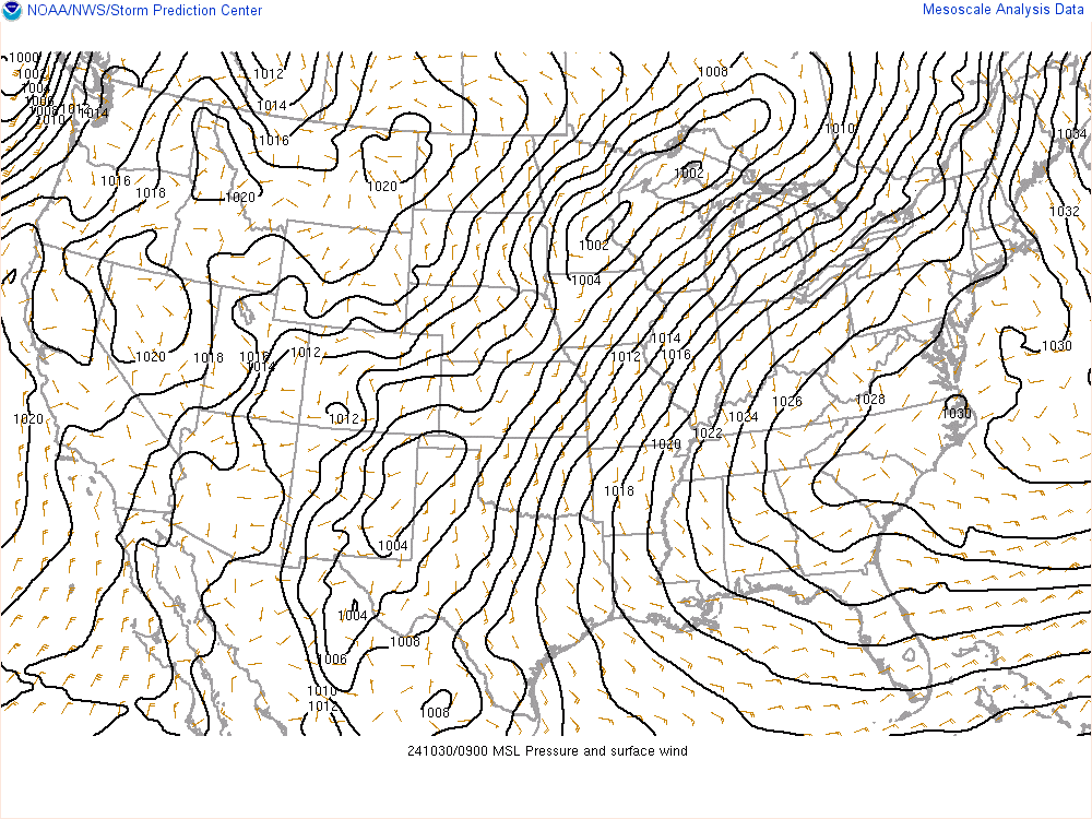
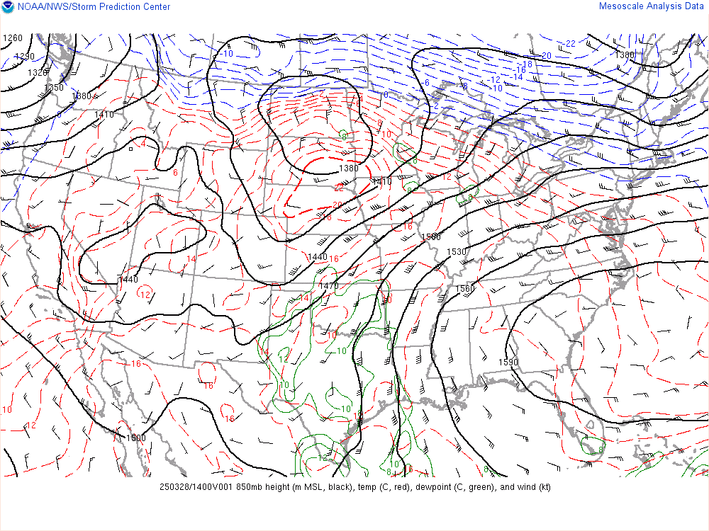
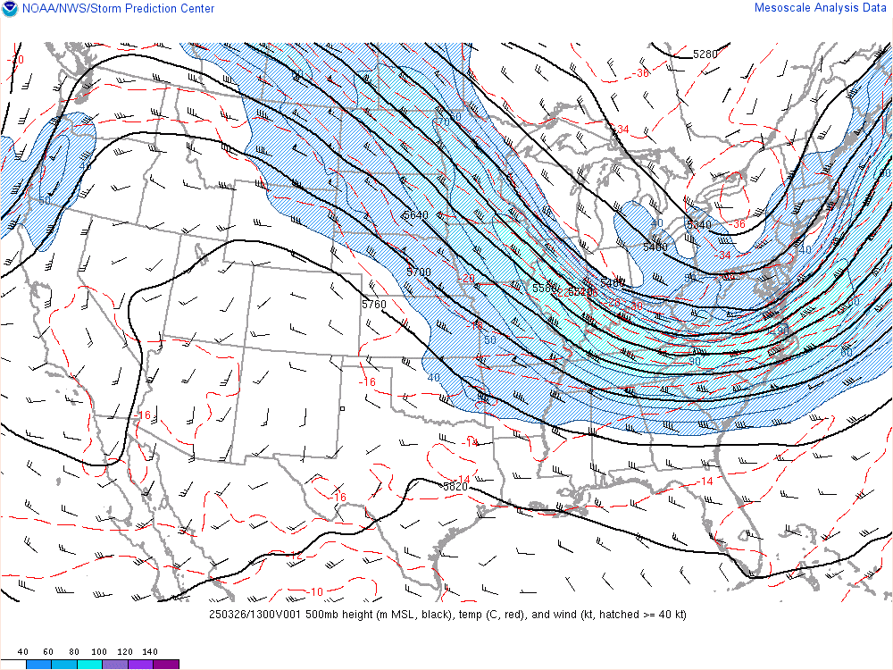
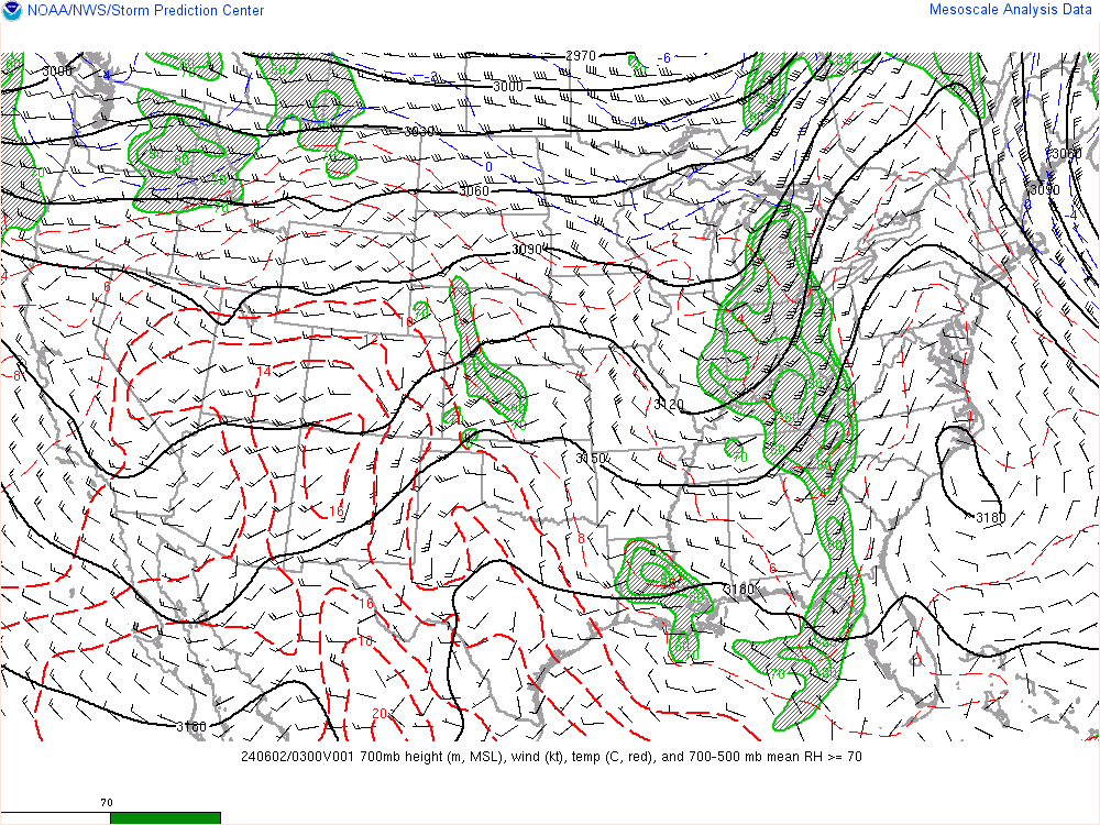
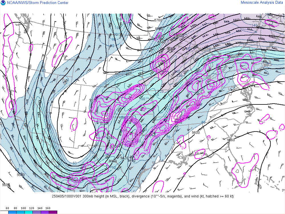
Well, after the storm system that hit earlier this week, with heavy rain, high winds, and transitioning to heavy thundersnow, it seems as if the weather pattern will be repeating itself, but in a much different way.  First of all, I want to show you the analysis maps, to show you where the systems are located and what they will do.
Now I will explain each of these maps, so that you will understand my forecast.  The first map was a surface map.  The lines that curved on the map are called isobars, or lines of equal pressure.  Therefore, by looking at the surface map, you can determine areas of high pressure systems and low pressure systems.  As you can see the initial surface low located over New Mexico, is very weak with only a central pressure of 1014 millibars.  Computer models are currently forecasting this low to strengthen some, but not much, to a central low pressure of 1008 millibars.  Even so, this will low pressure system will still produce quite a bit of precipitation over the next couple of days for many areas, even here (Oh, great!).  Some of this precipitation will be snow over the Central Plains and Midwest.  The heaviest snow will likely fall from northwest Kansas northeastward through Iowa, and into northern Michigan, with as much as 10 inches of snow.  This will probably be a quick moving system, with rain moving into our area by late tonight, or possibly even late this afternoon, depending on the dryness of the air.
Surface pressure and wind map


850 millibar temp and dew point map
700 millibar temp and RH map
500 millibar wind speed map
300 millibar wind speed map


The next map I would like to show you is a map of the 850 millibar layer.  What this means is that every location on this map has the same constant pressure in the atmosphere.  Therefore, lines of equal pressure are represented by lines of constant height, or the height in the atmosphere above of a certain location that experiences 850 millibars as a pressure.  On this map, you can see red and below contour lines.  These represent isotherms, or lines of equal temperature.  These help to identify air masses and frontal positions.  The first blue contour on the map indicates the freezing line, with isotherms behind it experiencing temperatures below 32 degrees.  The black lines illustrate height contours, and help illustrate the the general wind direction and speed at the 850 millibar layer.  When the wind moves at an angle to the isotherms, temperature advection occurs.  Temperature advection is the process of transporting air masses of different temperatures.  When the wind blows from warmer to colder air, warm air advection is occuring, and causes the temperature to rise in most layers of the atmosphere.  This process is what develops fronts on earth, and is the main reason for storm systems.  The 850 millibar map also shows dew point temperatures, but not dew points below 10 degrees Celsius.  As you can see the moisture plume on the map, this is where heavy rain is occurring right now, or is moving away.  As you can see just above us, warm air advection is occuring, which is why surface temperatures are rising, even though it is cloudy.  You can also see that there is a weak low on the map.
The next map shows the 700 millibar layer of the atmosphere.  On this map, isotherms are also indicated on the map, and so are height contours.  As you can see only slight warm advection is occurring in the layer, which is also supporting the warming of the surface temperatures.  The green fill on the map is indicating relative humidity.  The lighter green fill indicates areas of 70% relative humidity.  A general rule of thumb is that areas enclosed in 70% relative humidity on an upper air chart will most likely be cloudy.  This does not always account for low level clouds.  Areas of 90% humidity (darker green), usually indicating that some form of precipitation is falling in these areas.  As you can see, this system has quite a bit of moisture associated with it.  You can also see, the low pressure system on here.  As you may have noticed, the low pressure is intensifying with height, indicating that the surface system will intensify.
On the next map, is the 500 millibar map.  This map to the left is showing areas of constant wind speed (theoretically).  This is the map that you would usually look at to determine the  general trough/ridge pattern.  The wind speed and direction in the 500 millibar layer usually indicate the speed and direction that a system will move at the surface.  Generally, surface systems will move in the same direction, but at the half the speed of the winds of the 500 millibar layer.  But don't be fooled, you will not be able to determine the correct movement of this system just by looking at this map, as the trough is expected to change, as told by the next map.
On the 300 millibar map, this is where the jet stream is located in the atmosphere.  This is the layer of the atmosphere that you want to look at when determining where and how a surface system will move, and how the other layers of the atmosphere will change with time.  The pink contour lines on the map, indicate areas of divergence in the upper atmosphere, which divergence in the upper atmosphere helps initiate surface low pressure and convergence, generating precipitation.  As you can see above the storm system, are areas of divergence, which will also help a surface system to intensify.  Another general rule of thumb is that when an area of higher wind speeds (a jet streak), will cause an intensification of the trough.  As you can see, this what is likely to happen, while also intensifying the main storm.
So here is the forecast.  It looks like this storm will continue to move northeastward, allowing the precipitation shield to expand over a large portion of the Midwest.  Heavy snow will intensify over the plains and expand eastward, as an arctic air mass surges down from Canada.  As it collides with the warm air from the Gulf of Mexico, heavy rain will expand, causing heavy downpours over a large area and cause flooding in areas west of here.  Around here, the rain will not spread into the region until later this evening and later tonight.  By early Sunday morning, a steady rainfall will be underway, with possibly heavy downpours at times, tapering to showers by the afternoon hours.  With the shorter duration of this event, I expect precipitation amounts through Sunday Night to be in the quarter inch to an inch range, which will likely not cause flooding problems by itself, but will likely exacerbate pre-existing flooding problems.  If the system is stronger than expected, and the system draws more moisture from the Gulf of Mexico, northward into Indiana and Ohio, rainfall may be heavier, but at this time it does not look like this will happen.  Then, overnight Sunday, showers will become more numerous and widespread likely becoming steady rain by Monday morning.  This second round looks to bring more precipitation, with possibility of different precipitation types.  This second round will likely make flooding much worse over Northwest Ohio and Northern Indiana.  There are some models that are hinting at a winter storm event over the area by Monday afternoon and night.  These models are forecast arctic air to move into the area, changing the rain to snow by Monday afternoon.  Some of these models are forecasting the snow to become heavy at times, especially north of U.S. highway 24.  The NAM is even showing the possibility of some 12-18 inches of snow in parts of Northern Indiana, while areas north of U.S. Highway 24 will likely have more along the lines of 6-8 inches, if this model verifies.  If we look at the ECMWF, this model is generally right in the middle of both the GFS (which is taking a southern route with this system, bringing the heaviest snow south of this area) and the NAM (which has the northerly route with this system, bringing the higher snow totals just to the north of here in Northern Indiana and Michigan.).  If the ECMWF were to verify, it looks most of Northwest Ohio would be in for a very hefty snowstorm, with the possibility of over 12'' possible!  Right now, I am very uneasy about a solution for heavy snowfall as it seems to early.  Generally, the ECMWF is the best at winter weather forecasting, so we'll have to keep looking at the next several runs.  I will update if anything changes in the forecast.  If you want to see the analysis maps yourself, go to this link: SPC Mesocast.


Tuesday, November 29, 2011

Winter Storm Alert

Finally, after hours and hours of heavy rainfall and gusty winds, the heavy rain has switched to heavy snow over a large portion of Northwest Ohio and Northeast Indiana.  With the earlier than anticipated changeover to heavy snow, I expect snow totals to be higher than originally expected.  Instead of the 2-5 inches for extreme western Ohio, expect 4-8 inches with possibly higher amounts.  One thing that could go wrong is that the snow would end early than anticipated, which would bring snowfall amounts to 3-6 inches.  Farther east, near Defiance and Toledo, I expect 1-3 inches or possibly higher, with snowfall totals around an inch east of this line.  The Winter Storm Warning is only for extreme western Ohio, for the counties of Paulding, Defiance, and Williams Counties.  The winter storm warning is calling for accumulations of 4-8 inches or more in these areas, with the possibility of extremely heavy snow and thundersnow.  Just a few minutes ago, there was thunder and lightning here in Antwerp.  I have heard that thundersnow has been reported all over Northeast Indiana and Northwest Ohio, so expect more thundersnow through 7 or 8 tonight.  Even though radar is showing the back edge of the snow moving westward through Northwest Ohio, I expect that as the storm system turns to the northeast, that the snow will increase in intensity and duration.  The snow will gradually lighten during the early morning hours and taper off by sunrise.  Scattered light snow showers should continue through the morning hours, with cloudy conditions prevailing for most of the day.  Total snowfall accumulations will be 5-8 inches in Northeast Indiana, with 8-11 inches possible in Angola and Hillsdale, Michigan, while snowfall totals in Northwest Ohio will range from 4-8 inches in Paulding County to 8-11 inches in Williams County.

Tricky Forecast.

Right now, moderate to heavy rain is located over most of the area.  This has caused rainfall amounts of one to two inches over most of Northwest Ohio.  One thing that may be a problem is the fact that the dry slot is currently trying to edge into the area, although it is having a hard time of it.  If it does end up moving into the area, expect rain to taper probably by 7 or 8 a.m.  The rain will then move back into the area by 10 a.m., and intensify, and at the same time snow will begin to develop over Western Indiana.  These snow bands will be developing a lot sooner than what was expected last night, as the cold air aloft and at the surface will make snow and convective snow bands favorable to form farther west.  At the same time, heavy rain will persist and intensify after the dry slot moves out, while cold air nudges into the area, dropping temperatures from the upper 30's and lower 40's, to temperatures near freezing by mid-late afternoon.  This will finally allow rain to transition to snow.  Now the National Weather Service has issued a Winter Storm Watch for most of Northeast Indiana calling for 4-8 inches and possibly more.  I see no reason why they don't issue a winter weather advisory for extreme western Ohio, as models indicate that we could get in on the heavy snow also.  Actually, the NWS states in the forecast that Antwerp will probably have periods of heavy snow tonight, but only a 1- 2 inch accumulation, which is what is indicated by the NAM and the GFS.  At this time, as most models have made an eastward shift in the storm, I think that the NAM and GFS have the snowbands to far west, as they have the cold air entering the region later than what most models do.  My forecast calls for a solid 2-5 inches is possible over extreme western and northern Ohio, while areas east of a line from Defiance to Toledo will receive about an inch or less.  Any towns in between will receive 1-3 inches of icy snow.  Fort Wayne to Angola and Coldwater, will likely see snowfall amounts of 5-8 inches, especially if the heavier banding sets up.  This snow will likely be wet and heavy when it falls and it will likely freeze to the roads after several hours of heavy snowfall.  So for my forecast here it is.  Today I expect the dry slot to move through bringing a temporary end to the heavy rain and flooding.  By 10 a.m. or so, I think the rain will redevelop and reintensify, especially as the low strengthens.  Winds will also increase from the north, with gusts over 35 mph.  Temperatures will be falling slowly throughout the day, and temperatures will probably be near 35 by 2 p.m.  Rainfall amounts between 1-2 inches possible.  Rain will mix with snow by 2 p.m. and completely change over to snow by about 4 p.m.  Rain will not change over to snow for areas east of Paulding until about 5 p.m.  Tonight as the low intensifies, convective heavy snow bands will set up, with the potential for thundersnow, which will enhance snowfall accumulations, especially west of Fort Wayne where the potential for over 10 inches of snow remains a possibility.  These heavy snow bands will move through extreme western Ohio, bringing snowfall rates of 1-2 inches an hour, for a couple of hours, which if the storm is farther east than anticipated, expect these to produce heavy snowfall accumulations.  My forecast is calling for a solid 2-5 inches (this may change by this afternoon, as uncertainties exist) for extreme western Ohio, while in between Antwerp and Defiance, I expect 1-3 inches, and anywhere east of Defiance less than one inch.  From Fort Wayne to Angola and Coldwater, I expect 4-8 inches possibly 10, and farther west over Columbia City and Warsaw, I even expect 6-10 inches. (Again, this forecast may need revised by this afternoon, as uncertainties still exist.)  No matter how much snow we get, I believe the snow will last through 3 a.m. before tapering off, with leftover snow showers for Wednesday.  If anything changes I will have an update by this afternoon.  Stay tuned for further updates.
Monday, November 28, 2011

Crazy Forecast. Flooding to Heavy Snow.

Over the next two days, expect some of the craziest weather that has hit around here in a long time.  Everything from flooding to heavy snow will be prevalent across the area.  To begin, I want to start with tonight's forecast.  Right now, current radar is showing bands of moderate to heavy rain beginning to move back into the region.  Here is current radar: NEXRAD radar.  According to the National Weather Service, light rain will overspread the region through the afternoon, bringing only light rainfall amounts for the time being.  By 7 p.m., I expect heavier rain to overspread the region.  Thermal profiles indicate that with the cold temperatures aloft and strong lifting could create pockets of snow tonight, but only accumulating to a dusting and more likely west of here.  The rain will intensify later tonight, becoming heavy areawide and leading to flash flooding by morning in some areas, especially in areas that saw flooding from the storm last week and Sunday night's rainfall.  Winds will also strengthen throughout the night, with gusts to 30 mph.  Overall tonight, I expect rainfall totals near an inch in most areas.  This is one of the reasons that the National Weather Service issued a flood watch.  By Tuesday morning, rain will continue and possibly become heavier during the mid morning hours.  Temperatures will not warm much during the daylight hours, probably dropping throughout the day.  Starting temperatures will be in the lower 40's, and by afternoon, temperatures will probably drop into the mid 30's.  According to some of the computer models, a dry slot may work its way into areas south of Fort Wayne and Van Wert.  This could cause lower rainfall amounts than expected.  I am very cautious about this, mainly because of how much moisture is being brought into this system.  Even if there is a dry slot, I expect the rain to only lighten up or becoming showery for a few hours.  By about 4 or 5 p.m., precipitation will reintensify, with rainfall becoming heavier across the area.  By this time, flooding will be a serious concern, as 2 to possibly 3 inches of rain will have fallen.  Here comes the tricky part in the forecast.  Around this same time, some computer models are suggesting that snow will begin to mix in with the rain, especially just west of Fort Wayne.  Depending on when the rain mixes with the snow, will determine how much snow falls Tuesday Night.  At this time, the mixing will likely begin here in Antwerp around 5 p.m.  By 7 p.m., the rain will completely change over to heavy wet snow, as a large band of heavy snow makes it way into the area.  From past experience, during the type of snow events that happen at the end of heavy rain events, usually the Weather Service and computer models under forecast snowfall amounts.  We'll see what happens, but I think that the snow may be heavier than what many forecasts are predicting.  The snow will likely last through the nighttime hours, probably until about 3 a.m., becoming progressively lighter, with the heaviest snow falling at about 9-11 p.m.  So here are my thoughts on precipitation amounts.  As more data comes in I will update either this evening or tomorrow morning.  For rainfall amounts, most of Northwest Ohio will likely see in the range of 2 to 3 inches with possibly higher amounts.  This will cause flash flooding, flooding on roadways, and moderate flooding along the Maumee River basin.  This greatly exasperate flooding problems right now.  If the dry slot does move farther northward then expected, then expect rainfall amounts of around 2 inches.  As for snowfall amounts, this will be trickier, mainly because early season snow events are harder to forecast with all of the warm air around.  Right now I'm expecting snowfall amounts on the order of around an inch or less for areas east of Defiance.  From a line from Antwerp to the Michigan state line, expect snowfall amounts of around 2-4 inches with possibly higher amounts in areas that experience heavier snow.  This may need to be lowered or brought up especially since Antwerp is right along the line for heavier snowfall.  If the storm shifts farther east, expect as much as 3-6 inches in Antwerp.  If it shifts farther west, expect 1-2 inches in Antwerp.  Along a line from Fort Wayne to Coldwater, Michigan, I expect the heaviest amounts with possibly 3-6 inches falling, and near 5-7 inches in Coldwater.  This is also debatable, so expect changes in the forecast.
The 12z GFS is forecasting 2-4 inches for Antwerp, while areas north and west of Fort Wayne will see 6-10 inches of snow.


Sunday, November 27, 2011

My Thoughts on the Long-Range Forecast.

   As quite a few meteorologists have, I have come to the conclusion that I need to make few corrections to my long range forecast.  In my original final forecast made back at the end of October and early November, I stated that the second half of November would be very cold and somewhat dry around.  As we all know this didn't happen.  In fact, quite the opposite happened, with a somewhat warm and very wet pattern making it seem as if winter would never come.  In this article, I will try to explain my revisions to the forecast as well as what went wrong. 
   For the final days of November (where we are now), I expect very cool temperatures after the last storm system comes through.  On Wednesday, November 30, I expect temperatures only in the mid to upper 30's, under partly to mostly cloudy skies.  These temperatures are only slightly below normal and not so bad for this time of year.  During this time period, I expect that the teleconnections will finally become favorable for winter weather across the U.S., especially as we head into the first and second weeks of December.  Currently, (as of Sunday, November 27) the Arctic Oscillation Index, a teleconnection that indicates the strength of the polar vortex, is still strongly positive.  The Arctic Oscillation (AO), is a teleconnection (mode or phase of the atmosphere) that changes due to changes in temperatures in the lower stratosphere (layer of the atmosphere just above the troposphere).  When these temperatures are above normal above the Arctic, surface temperatures warm, and create an atmospheric phenomena called the Greenland Block.  The Greenland Block is a ridge of high pressure above the Greenland land mass that causes a metaphorical "road block" in the jet stream.  Instead of the jet stream traveling west to east through the Atlantic, it takes a large northward swing into the Arctic.  This sets up a major trough in the upper atmosphere over much of North America, sending very cold air southward during its NEGATIVE PHASE.  Usually, when the AO is negative cold and wintry weather is prevalent over the United  States during the winter months.  During its positive phase, just the opposite is true.  The positive phase causes a zonal or more west-east flow in the jet stream, allowing for warm air to penetrate farther north into the United States.  Another index called the NAO, usually correlates strongly with the AO.  When these two are both in their negative phase, and there is very cold air in Canada and Alaska, a major arctic outbreak is likely in the Lower 48 states.  Over the last month or so, ever since that big Nor'easter hit the East Coast, both the AO and the NAO have been mainly positive, suggesting a warmer pattern for much of the United States.  This is exactly what happened.  Over the next several weeks, I expect both teleconnections to go negative, but it take longer than originally thought.  It seems the computer models are all over the place with where these indices will go over the next few weeks.  More than likely, I think that they will go negative especially by about December 15.  After this I expect, the winter forecast of a cold and snowy winter to hold prominent.  During the transitional phase from December 1 through December 14, I expect a few ups and downs in the pattern, with cooler than normal temperatures dominating throughout the period, while drier than normal conditions take hold in the beginning. 
   Another index that influences are weather quite a bit is the PNA.  PNA stands for Pacific North American index.  This teleconnection also has a positive and negative phase to it.  In its negative phase, positive height anomalies (higher than normal pressure) exist over the Central Pacific, while a trough (lower than normal heights or pressure), exists in the Western United States and a large ridge is present in the Southeast.  This, coupled with a positive AO/NAO will generally lead to very warm air spreading into the United States.  In the positive phase of the PNA, negative height anomalies exist over the Central Pacific and above normal height anomalies exist over the Western United States, while the in the East, a trough dominates.  When this is coupled with a negative AO/NAO, very cold air will likely dive deep into the United States, which explains the very cold weather during last winter.  Over most of November, the PNA index ranged from neutral to strongly negative, leading to the development of a southeast ridge, allowing for warm and humid air to spread from the Gulf of Mexico into the East.  Right now, computer models are in fairly good agreement on what this index will likely do.  It looks like it will become positive, allowing for a trough to develop in the East.  Because it is not coupled with a negative NAO/AO for the time being, only below normal temperatures will dominate for short periods of time, with some fluctuation in between.  All in all, until all of the teleconnections are in agreement, I expect only slightly below normal temperatures to continue from December 1-14.  After the fifteenth, I believe all of these teleconnections will align themselves in such a way that winter will finally hit hard, just like I said in the forecast. 
  For a brief summary of the long range forecast, to begin December, I expect temperatures to be slightly below normal, with highs in the mid to upper 30's.  After this Friday, a clipper system will move through, bringing some colder air and temperatures farther below normal in possibly the low to mid 30's by next week.  Next week, I expect temperatures to fluctuate a bit from below normal and some snow in the beginning of next week to temperatures near normal and some rain with any storm systems.  After next week, the week of the 12th, I expect this to be the week of change, with temperatures starting the week possibly slightly above normal, with temperatures in the lower 40's, and ending the week well below normal, with highs even in the mid twenties.  This will also be the time when I expect the storm systems to start coming back into the region as forecasts look like we will average below normal precipitation from December 1 through the 14, with an uptick in precipitation after the big cool down, likely in the form of snow.  After the changeover, I expect the rest of December to also be cold and snowy, heavier than normal lake effect snows and a couple of moderate snowstorms.  I would even hope for a snowstorm or blizzard during the week of Christmas!  For the end of December, unlike last year, I expect to end cold and dry.  By January, the same pattern may continue, but as of this time, I am really not sure if the pattern will reverberate back to what happened in November.  This is the official forecast.  If there are any updates I will revise my forecast again.

Crazy storm this week. Be Prepared for Snow.

This week looks to be a crazy one, especially in the first couple of days.  According to the latest computer model runs, rain should continue today as a large storm system moves northward into Canada. 
So far, the rain has been light, but the National Weather Service has said that rain bands are likely to intensify throughout the morning hours, bringing pockets of heavier rain.  Therefore, most areas today will pick up around a half inch.  Temperatures already reached a high of 59 today, so I expect temperatures to continue dropping, dropping to below 40 by this afternoon, as a strong cold front makes its way through.  By tonight only showers linger, when the storm system will redevelop over the southern United States.  This next system will have plenty of moisture from the Gulf of Mexico to work with, so expect heavy rainfall totals with this next rain event.  It looks like rain bands will begin spreading northward by Monday around noon, starting as light rain and gradually becoming heavier.  The rain will gradually get heavier through the night as the storm system strengthens.  The National Weather Service expects rainfall totals on Monday from three-quarters of an inch to over an inch, and I agree with them, mainly because of how much moisture is associated with this system.  Tuesday, heavy rain still continues with dropping temperatures once again from the lower 40's, to possibly lower 30's by afternoon.  As temperatures drop, and as strong lifting occurs in the atmosphere over Indiana, Ohio, and Michigan, I expect pockets of snow to develop during the day, so don't be surprised if all of the sudden it starts to snow very heavily during the afternoon Tuesday.  This is where the tricky part comes in.  During the night, computer model runs have trended to a significant snow event area wide, with the heaviest snow totals right along the Indiana border on northward into Michigan.  While areas east of Defiance will probably not see much snow accumulation, towns right along the Indiana border in Northwest Ohio will likely see at least moderate accumulations (the exact words of the National Weather Service), with heavier snow accumulations possible more likely in Northern Indiana and in Michigan.  Right now, computer models are all over the place with snow accumulations, with the JMA producing over a foot of snow to the area, while the GFS is forecasting 1-2 inches and the NAM is forecasting 3-5 inches at most.  If enough dynamic cooling takes place, and the surface cold air mass is cold and deep enough for snow, I would expect around 2-3 inches at a MINIMUM, with the possibility of snowfall amounts approaching 5 or 6 inches especially farther north.  This will be something interesting to watch.  All in all, rainfall totals from Sunday afternoon through Tuesday Night, will reach over 4 inches, inducing river flooding and flooding in low lying areas.  Depending on when the cold air arrives, expect travel issues as Tuesday Night's snow will heavy and wet in nature with several inches possible.  After the entire storm system passes through, the coldest air of the season will finally arrive, dropping temperatures in the mid to upper 30's, with some days in the lower 40's.  By Friday, a small clipper system will bring snow showers, and renewed cold air mass, with highs possibly in the lower 30's, and lows in the lower 20's.  After this, the computer models have gone crazy, with some pushing all of the cold air back out of the region.  Even if this does happen, all signs are pointing to the fact that the teleconnections will line up by at the latest the 15th, where winter will finally arrive.  With this, I also expect that by Christmas, winter will be well underway, with bitterly cold air and hopefully a white ground.
HPC rainfall prediction for the next five days.

Wednesday, November 23, 2011

Forecast through early next Week.

After all that rain we had yesterday, amounting to over an inch in most areas, clearing skies, light winds, and a nearly saturated lower level of the atmosphere, will allow for the development of fog, mainly in areas west of Fort Wayne, where skies have cleared longer and the wind is lighter.  I don't expect much fog around here this morning, except for a few patchy areas, and where it does form, it will be lighter, and not dense.  So far skies have cleared pretty nicely, as that wet rainstorm has marched off to the east, and intensified.  In fact, a rather large area of heavy snow has developed over most of Vermont, New York, New Hampshire, and Maine.  Some parts of these areas will pick up close to 10-15 inches of snow, while areas farther south will see 2 to 4 inches of rain, with embedded thunderstorms.  During the day today, expect temperatures to be warmer than yesterday, with highs in most areas reaching the lower 50's, under sunny skies.  After the storm system moves offshore, a ridge is forecasted to build into the area tonight, allowing for the continuation of clear skies and warm temperatures reflecting September and not November.  Tonight, more humid air will build into the region, along with the ridge bringing westerly winds aloft and clear skies, will allow for the formation of possibly dense fog tomorrow morning.  So beware, for those of you who travel on Thanksgiving Day, as tomorrow's fog will probably be widespread.  On Thanksgiving Day itself, temperatures will rise from the upper 30's in the morning hours to the mid fifties, making a very unseasonably warm day.  Light winds will continue on Thanksgiving, as the ridge moves quickly to the east, bringing southerly winds aloft.  This will allow for even warmer air to move into the region, and by Black Friday, temperatures could even hit the lower 60's.  At this point, I'm not actually sure if this will happen, because the sun is not strong enough to cause temperatures to rise into the lower 60's this time of year.  Second of all, if their is fog again Friday morning, I would not expect much warming until afternoon, allowing for temperatures to only hit the mid fifties.  By late afternoon and evening, increasing clouds will prevail, which will mean temperatures will not drop as much as they are forecasted to the night before.  By Saturday, I believe temperatures will hit the mid fifties, because the cloud cover will likely reduce any daytime heating.  Saturday afternoon, we could see some showers, but they will mainly be confined to areas west of Indiana.  By Saturday Night, showers and thunderstorms will be likely once again, possibly renewing the threat for heavy rainfall.  On Sunday, temperatures will fall into the mid 40's, as the low pressure system will move eastward, causing temperatures to fall and a decrease in rain chances.  By Monday, a secondary low pressure system forms and moves northward over the area, renewing rain chances but also drawing in cold air, as a large cut off low forms.  This will bring the chance for snow into the forecast.  In fact, a major winter storm is possible by next week around here, but because computer models can't seem to agree, I will refrain from making any forecasts on it until the models have come to a consensus.  After that, well, the computer models went haywire with the teleconnections that were supposed to go negative, so I really have no clue whether the cold weather will hit in December.  The GFS ensembles are still forecasting the NAO and the AO to take a nosedive into negative territory, finally allowing for cold air to dive into the United States.  Even if this doesn't happen, I still expect winter to be a mild one, mainly because all of that cold air is building up in Canada, and because of how much the polar ice caps are melting, they are allowing for warmer air to be trapped up north,  reinforcing the Greenland block, which is why I expect it to show up this winter for periods of time.  If the block doesn't show up until January, then expect even colder temperatures than originally forecast.  By February, I still expect this month to be our worst month in terms of cold and snow.  Stay tuned for further updates.
Monday, November 21, 2011

Forecast Update


Monday Night: Low 37. Skies mostly cloudy to overcast, as storm system begins to move northward.  Rain chances increase through the overnight hours.  Steady rain develops north of the warm front.  Winds increase from the east and northeast as pressure gradient tightens.
Tuesday: High 47. Skies overcast, as storm system moves northeastward.  Steady rain ahead of the warm front moves across the area, with some pockets of heavier rain by afternoon.  Thunderstorms are possible especially by early evening.  Rainfall amounts between a half inch and one and a half inches, with some areas especially in areas south of a line from Fort Wayne to Defiance will see up to two inches in the heavier thunderstorms.  Winds increasing from the east.
Tuesday Night: Low 38. Skies overcast throughout the night. Rain and thunderstorms continuing through midnight, becoming more scattered and lighter by the early morning hours.  Rainfall amounts about a half inch.  Winds diminishing in the overnight hours.
Wednesday: High 51. Partly cloudy to mostly sunny. Ridge rapidly building in to the area, bringing warm air aloft, and sunny skies.  Temperatures rise slowly after chilly morning.
Wednesday Night: Low 33.  Partly cloudy during the overnight hours, clearing by early morning. Chilly night, as ridge builds into the area bringing clear skies, light winds, and dry air to allow for rapid cooling during the night.
Thanksgiving Day: High 55. Mostly sunny and warm.  Ridge quickly moving eastward, causing a westerly flow to bring even warmer temperatures to the area.  Storm system begins to develop in the west, in the southern Rockies.
Thursday Night: Low 39.  A more humid air mass moves into the region, as ridge is still moving eastward, changing the westerly flow aloft to a southerly flow.  Clouds begin to move back in.  Partly cloudy.  Storm system still developing over Southern Rockies.
Black Friday: High 59. Partly cloudy early becoming mostly cloudy by late afternoon. Windy and blustery day.  Very warm with even more humid air mass moving in.  Major trough pushes storm system from the Southern Rockies through central Mississippi Valley, causing increasing pressure gradient and gusty winds.
Friday Night: Low 40. Mostly cloudy to overcast.  Rain moving in the early morning hours after 3 a.m. Wind increases ahead of the next storm system.
Saturday: High 55. Overcast with rain and thunderstorms by afternoon.  Wind begins to subside.  Heavy rainfall is possible.
Sunday: High 51. Overcast with rain and possibly a thunderstorm.  Rapidly dropping temperatures by late evening, by as much as 40-45 degrees.
Monday through Friday of next week: AO and NAO finally go negative, allowing that major trough to develop into a rather large upper level low, sparking storm systems periodically through the last week of November and the first few days of December.  During this time period, we could see some snowfall, on the amount of 1 or 2 inches, especially in early December.  This upper level low will pull some very cold air into the area, with some days not even making it above freezing.  Snow is a very good possibility during this time. 

Late November through December Long range forecast.

 Some of you may be wondering, "What in the world is going on?".  Well, I've got to tell you, I'm wondering the same thing.  Over the past 20 days, most days have seen above normal temperatures.  Truth be told, we have seen some pretty chilly days in between these warm periods.  Even this week, most computer models are forecasting a major ridge to form over a large portion of North America for the holidays.  This would cause a relatively warm and humid air mass to surge northward into a large chunk of the United States.  Along with this warm air mass, sunny conditions will prevail for Thursday and possibly Friday.  As the polar jet stream is very strong this year, the ridge will shoved out just as fast as it came in.  By Friday Night, clouds will be on the increase, ahead of the next strong storm system.  This storm system will develop quite rapidly, as a major trough develops in the Plains and surges eastward.  According to the GFS model, heavy rain and quite possibly thunderstorms will likely develop by Saturday and into Sunday.  During these days, temperatures will rise into the mid fifties, much above normal levels.  The storm system won't stop there.  After the surface system leaves, a rather large upper level low will develop and remain for several days, bringing colder air and possibly areas of snow, bringing the first accumulating snow of the season to many areas.  After this it is unclear what will happen, but the GFS is forecasting that the AO will plummet to negative values for the first time in several weeks.  This may cause a major trough to form for the first and second weeks of December, bringing widespread snow and cold to much of the Central Plains and East.  With all of that cold air in Canada, I'm sure it will spill southward into the US.  This would make the weather pattern eerily similar to last year.  In fact, according to the latest run of the GFS model, towards the beginning of December, that upper level low mentioned earlier, will likely cause multiple storm systems to form and swing around it, also drawing in very cold arctic air to start the season off.  With low upper level height anomalies, combined with surface cold air, and plenty of moisture to work with, I'm sure that we will see quite a bit snow for the first two weeks of December.  As for the rest of December, if the AO and NAO remain negative, and the PNA remaining positive, expect cold temperatures and frequent bouts of snow to continue even through Christmas.  Unfortunately, I don't believe any major storms will likely form this period, as most of the storms will traipse up the East Coast.  I will keep you updated as December gets underway.
   There is one thing I do want to touch up on is dealing with the current La Nina.  The values I want to speak about are the SOI values, Southern Oscillation Index.  The Southern Oscillation Index is determined by taking the difference of sea level pressure readings from Tahiti and Darwin, Australia.  If this difference (Tahiti-Darwin) is negative, usually this correlates to either an El Nino or weak La Nina.  If this difference is positive, usually this means that either a weakening El Nino exists or a rather established La Nina event is underway.  If values are either very high or extremely negative, this indicates a solid ENSO event is underway.  Today, the Climate Prediction Center released their weekly analysis of the ENSO.  They found that SOI values are only about 10.1, which is pretty modest for an expected strengthening La Nina.  Some meteorologists are pointing out that they may need to revise their winter forecast, due to the SOI values being much lower than last year's.  I really don't agree with this, mainly because first of all every ENSO event is different so SOI values will range differently.  Second of all, generally second year La Nina's are usually weaker than the previous La Nina, with generally weaker SOI values.  Also, during east and central La Nina events, SOI values will be weaker than normal because of the fact that the most dominant weather influence will be located farther east.  When I look at how strong a La Nina is, my first index will not be SOI values.  I will first look at sea surface temperature anomalies across the equatorial Pacific.  Currently, anomalies are between one and three degrees Celsius below normal, indicating a moderate La Nina is already underway.  The second factor I look at is 850 millbar and 200 millibar wind anomalies.  If the 850 millibar mean wind over the equatorial Pacific is stronger than normal from the east, this means the trade winds are stronger than normal, indicative of a persistent La Nina farther east.  Right now, 850 millibar winds are stronger than normal from the east over the Equator.  If 200 millibar winds are stronger than normal from the west, this is also indicative of a La Nina because higher pressure aloft is located over Indonesia during a La Nina, and lower pressure aloft is located over the equatorial Pacific, meaning the winds will blow strongly from Indonesia to Peru.  This is what I have been observing over the Pacific Ocean.  I believe with these factors in play, plus a favorable MJO (I will explain MJO in another blog post.) in December, has lead me to believe in the strengthening in the La Nina and SOI values during the month of December and peaking in February and March going along with the CFSv2 computer model's forecast.  Other things such as NAO, AO, and PNA, have made me shaky with this winter's pattern, as they have not been consistent with many forecasts in the month of November.  We will have to see if the GFS and ECMWF are right in their forecast for a change to a negative NAO/AO along with a positive PNA.  If these factors do not turn as they are forecasted, expect a winter that is not as cold as was originally expected, with most of the cold air bottled up over Alaska, Canada and the Northern United States.  The good thing is that if these factors do not come into play, if it is not as cold this winter, expect heavier precipitation, and a greater chance for a very stormy and snowy winter, just like the Farmer's almanac says.  According to extremely long range forecasts, this may be our last hurrah winter, as next winter there is expected to be an El Nino in the Pacific, making it very unfavorable for snow around here.  In fact, next winter, we may say a return in Nor'easters and East Coast snowstorms, while the Midwest and Northern Plains is snow starved.  With the forecast through December 2011, I will keep you updated if something changes.  Other than that, this is the official forecast.  Stay tuned.

Sunday, November 20, 2011

Forecast Update

According to the latest 06z GFS run, a rather large area of Northwest Ohio and Northeast Indiana may see as much as 1.5-2 inches of rain from the storm on Tuesday.  Depending on where the heaviest band of rain sets up, this forecast may verify.  But the last several runs of the GFS model have shown the storm trending slightly southward, bringing the heaviest rain south of a line from Auburn to Toledo.  If the models continue trending south, I will drop this line to Fort Wayne to Toledo.  Another than that, it looks like skies will be clearing out Wednesday, with partly cloudy skies by afternoon.  Temperatures will be rather cool as the front moves through the area, with highs only expected to hit the low 40's and possibly upper 30's, if the cold front is strong enough.  By Thanksgiving Day, an upper level ridge is expected to build into the area, bringing above normal temperatures once again in the lower 50's to lower 60's.  Skies will also range from partly to mostly sunny.  By Friday, the ridge will have moved so that southerly flow develops aloft helping to warm surface temperatures.  If the warming is strong enough, I expect that temperatures will reach into the lower 60's, with increasing clouds throughout the day.  By Saturday, a major trough will develop in the plains, bringing stormy conditions back to the area.  According to the GFS, heavy rain and thunderstorms appears likely Saturday into Sunday.  THIS has remained consistent for the past several runs, which makes me think there might be a major storm system this weekend.  At the end of the storm, there looks to be snow developing, with colder surface and upper air temperatures.  This snow could turn heavy enough for our first accumulating snow of the year.  The greatest snowfall accumulations will occur north of a line from Fort Wayne to Toledo.  But remember this is a week from now, so this all may change by then.  After this I expect several major troughs to develop across the Midwest, bringing widespread cold and snowy conditions with each shortwave that moves around the base of these troughs.  Hopefully, by later this afternoon, I will release my long-range forecast update for December, as things look pretty interesting for next month.  Stay tuned for further updates.

Saturday, November 19, 2011

Official Forecast through Wednesday. Forecast Discussion.

Official Forecast from the Forecast Center

Today: High 53. Temperatures will continue climbing slowly, with increasing winds and cloud cover throughout the day.  Mostly cloudy to overcast.  A chance of scattered light rain showers during the afternoon.  Low pressure system moves east-northeast near Northern Illinois by early evening.  Winds from the south at 20-25 mph in the afternoon. Stronger gusts possible.
Tonight: Low 47. Temperatures dropping very slowly as warm air advection increases in the mid levels.  Winds will begin to subside overnight, with winds from the southwest at 10-15 mph.  Chance of scattered showers as the low pressure system moves northeast into Canada.
Sunday, November 19: High 52. Cold front begins to move through tomorrow. Temperatures dropping through the afternoon. Winds from the west-southwest at 15-20 mph. Chance of rain and showers throughout the morning and early afternoon.  Overcast.
Sunday Night: Low 38. Cold front has moved through completely.  Showers move out of the area.  Skies still remaining mostly cloudy to overcast. System redevelops in the south towards the overnight hours. 
Monday: High 48. Skies remaining overcast as storm system redevelops in the southern Mississippi Valley.  Most if not all of the rain will remain south of the area, unless the storm system redevelops farther north.
Monday Night: Low 37. Skies mostly cloudy to overcast, as storm system begins to move northward.  Rain chances increase through the overnight hours.  Steady rain develops north of the warm front.  Winds increase from the east and northeast as pressure gradient tightens.
Tuesday: High 46. Skies overcast, as storm system moves northeastward.  Steady rain ahead of the warm front moves across the area, with some pockets of heavier rain.  Winds increase even more from the east.

Tuesday Night: Low 31. Skies overcast before midnight, becoming mostly cloudy to partly cloudy by the early morning hours.  Chance of rain or snow in the early evening.  Winds diminishing from the northwest.
Wednesday: High 44. Partly cloudy to mostly sunny.  Cold temperatures remain after frontal passage.  The next storm system develops over the Rockies, to affect the area by Friday and Saturday.


Forecast Discussion

During this time, I believe it will be almost always cloudy through at least Monday.  According to the latest GFS prog., the storm system that was originally thought to head through the Tennessee Valley, will move more northward than was originally forecast.  This is because the southeast ridge will be redeveloping after today's storm system moves through, in association with a positive AO and positive NAO regime.  Today through Sunday, showers will be scattered and light in nature, along with gusty winds today, and diminishing weaker winds tomorrow.  The current storm system will move through the area later tonight, bringing with it scattered light showers around here, and a heavy snowstorm in Wisconsin and Minnesota.  The storm system and its associated pressure gradient, will also move out of the area tonight, causing the diminishing winds.  Not much clearing is expected Sunday, as showers are still anticipated in the morning hours, with only mostly cloudy skies in the afternoon.  By Monday, the storm system will redevelop in the southern Mississippi valley, and lift northward.  It's associated warm front will cause clouds to increase once again, but the rain should remain south of the area.  Monday night, if the storm system does make a more northeastward turn, then expect rain to develop overnight Monday.  If it does not, expect a few showers on Tuesday, and blustery winds, along with dropping temperatures.  Tuesday, if the storm system makes the turn to the north, I would expect steady rain with a few embedded thunderstorms north of the warm front.  Heavy rain is even possible, with an inch or so possible according to the latest GFS forecast.  After Tuesday Night, expect clearing skies, and much colder air to infiltrate the region.  I would even expect temperatures to be colder than what I'm forecasting right now, as these temperatures are based off the GFS model output, which has had a warm bias.  Wednesday into Thanksgiving Day, expect temperatures in the lower 40's, and nighttime lows in the upper 20's and lower 30's, under clear skies both days.  By Friday, temperatures will be rebounding again, in advance of a potentially much stronger storm system, which would bring heavy rain to the area next Saturday and Sunday.  Stay tuned for further updates.


Friday, November 18, 2011

Posting

I will be posting a five-day forecast soon, so stay tuned.  I will be starting to post more often than I have been.